SPECIAL ANNOUNCEMENT |
 |
Little Cottonwood Canyon will be closed this morning from 7 to about 9 am for test firing of their cannons for avalanche control. This will occur from Maybird through the lower Snowbird entries. They will do test firing again on Monday morning.
I will give a talk tonight in Park City titled the Science of Avalanches. It will be at the Treasure Mountain Middle School on Kearns Blvd at 6:30 pm.
Yesterday, I finally found time to create a couple of important, online tutorials, one on the always-confusing and controversial subject of Danger Ratings and the other on the Avalanche Danger Rose. You can find links to them in our Education section of our web site www.utahavalanchecenter.org and we will eventually find time to add hotlinks on the home page and advisory.
Remember, if you read this advisory via email, you are missing much of the important information on our web site. So be sure to make www.utahavalanchecenter.org a regular stop on your daily routine, especially the Current Conditions page where there is a chronological list of all the observations, profiles, avalanches, photos and videos. I check it twice per day just to keep up. |
|
|
BOTTOM LINE
Danger by aspect and elevation on slopes approaching 35° or steeper.
(click HERE for tomorrow's danger rating)
|
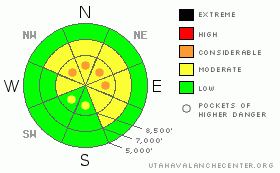
Danger Rose Tutorial
|
Although the overall avalanche danger is MODERATE, there remains pockets of CONSIDERABLE avalanche danger on any slope with deposits of wind drifted snow and also on steep, shallow, rocky slopes that face the north and east quadrants of the compass, especially ones with recent deposits of wind drifted snow. (see the Danger Ratings Tutorial and the Danger Rose Tutorial)
|
|
|
CURRENT CONDITIONS |

|
Snow surface conditions are 2-6 inches of dense, stiff snow that fell a couple days ago, which was accompanied by wind, making it a little punchy, but out of the wind, it’s not too bad. The sun exposed slopes are starting to get crusted.
|
|
|
RECENT ACTIVITY |

|
There was little significant avalanche activity in the backcountry yesterday including—miracle of miracles—Logan, where it has been extremely active these past couple weeks. A couple people were able to trigger small, hard, wind slabs along the upper elevation ridges yesterday. Avalanche control in Little Cottonwood Canyon produced three, sizable avalanches with explosives in upper elevation steep slopes with recent wind loading in unskied terrain.
|
|
|
THREAT #1 |

|
| WHERE |
PROBABILITY |
SIZE |
TREND |
|
|
|
|
| |
|
|
Over the next
24 hours.
|
|
|
The most salient problem today continues to be the lurking deep slabs, which are like Great White Sharks occasionally rising from the depths to feed. There is a huge amount of what we call “spatial variability” these days, meaning that conditions change significantly from one place to the next, sometimes just a few feet away. In other words, it’s a crap shoot. There are fewer and fewer places where you can trigger these avalanches because they’ve had more time to adjust to their load. But if you do trigger one, they will be large and dangerous. Most likely trigger points include thin, rocky areas, especially ones with recent deposits of wind drifted snow on slopes that face the north and east quadrants of the compass. These may become more sensitive as temperatures warm today. |
|
|
THREAT #2 |

|
| WHERE |
PROBABILITY |
SIZE |
TREND |
|
|
|
|
| |
|
|
Over the next
24 hours.
|
|
|
You will find a few lingering wind slabs, mostly along upper elevation, above-tree-line terrain. It has been a couple days since the wind blew with a few inches of dense snow, but there may be some slopes where you can still trigger them.
|
|
|
MOUNTAIN WEATHER |

|
The mountain weather remains dull with no significant snow in the forecast for the next 10 days or so. We may get a few clouds on Saturday and there’s a chance for some snow next Thursday, but otherwise, temperatures will warm up to near freezing on the ridge tops with daytime highs in the mid to upper 30’s down at 8,000’. Winds should remain light.
|
|
|
GENERAL ANNOUNCEMENTS |
Discount Lift tickets: Ski Utah, Backcountry.com, Alta, Deer Valley, Park City, The Canyons, Wolf Mountain, Snowbasin, Beaver Mountain, Brighton, Sundance, and Solitude have donated a limited number of tickets for sale at discounted prices.
Wasatch Powderbird Guides flight plan.
Dawn Patrol Forecast Hotline, updated by 05:30:888-999-4019 option 8.
Daily observations are frequently posted by 10 pm each evening.
Free UAC iPhone app from Canyon Sports.
Subscribe to the daily avalanche advisory e-mail click HERE.
UDOT canyon closures UDOT at (801) 975-4838
Send us your avalanche and snow observations. You can also call 801-524-5304 or 800-662-4140, or email to uac@utahavalanchecenter.org
Donate to your favorite non-profit – The Friends of the Utah Avalanche Center. The UAC depends on contributions from users like you to support our work.
The information in this advisory is from the U.S. Forest Service, which is solely responsible for its content. This advisory describes general avalanche conditions and local variations always occur.
Brett will update this forecast on Saturday morning. Thanks for calling. |
|
|
This information does not apply to developed ski areas or highways where avalanche control is normally done. This advisory is from the U.S.D.A. Forest Service, which is solely responsible for its content. This advisory describes general avalanche conditions and local variations always occur. |
|
This advisory provided by the USDA Forest Service, in partnership with:
The Friends of the Utah Avalanche Center, Utah Division of State Parks and Recreation, Utah Division of Emergency Management, Salt Lake County, Salt Lake Unified Fire Authority and the friends of the La Sal Avalanche Center. See our Sponsors Page for a complete list. |
