Ogden Avalanche Advisory

Forecaster: Bruce Tremper

BOTTOM LINE

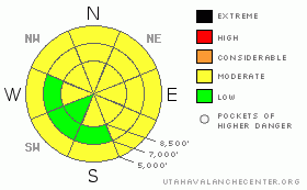
Danger by aspect and elevation on slopes approaching 35° or steeper.
(click HERE for tomorrow's danger rating)


Danger Rose Tutorial

The avalanche danger is MODERATE, which means that human triggered avalanches are possible on specific terrain features. You will likely find localized avalanche potential on steep slopes with recent wind drifts as well as a potential for larger, deeper avalanches on steep slopes that face northwest, north, northeast, east and southeast. If we get significantly more snow and wind than forecast, you can bump the danger ratings up a notch.

Logan area mountains: If you are headed to the Logan area mountains, realize there is a HIGH danger because they got much more snow over the past couple days. Be sure to check their advisory before heading out. Similar conditions may also exist in the northern parts of the Ogden area mountains such as Ben Lomond Peak.


CURRENT CONDITIONS

No snow overnight with the exception of an inch or two in the Logan and Ogden area mountains. Snow squalls are starting across much of the Wasatch Range this morning and we’re expecting about 4 inches out of these today. Temperatures are warm, in the mid 20’s in most mountain stations. Winds have been moderate along the ridges 10-20 from the west with as much as 30 mph on the highest peaks. The old snow surface is creamy, 2-day-old snow on the shady slopes (north through east), with some sun crusts on the sunny aspects.


RECENT ACTIVITY

There was remarkably little activity yesterday considering the vast hoards of people in the backcountry. In the Salt Lake area mountains, on Little Water Peak, which is a very steep slope on the Big Cottonwood-Mill Creek ridgeline, a skier stomped a cornice from the side and it propagated 150 feet across the peak, breaking 1-2 feet deep. It appeared to be a wind slab from recent winds (see a photo along with all the other cool observations on our home page by clicking Current Conditions). Also, one observer along the Park City ridgeline thought that skiers ahead of them triggered a couple 50’ wide slabs in the Monitors. I’m guessing that both of these areas slid earlier in the season and have remained thin and weak. There was also a sizable avalanche triggered in the Logan area mountains, which you will also find in Current Conditions. Finally, people were reporting wet sluffs on the Weber Canyon road this morning from rain or wet snow overnight.


THREAT #1

WHERE PROBABILITY SIZE TREND
      Over the next 24 hours.

There are three different, distinct avalanche problems today. First, as always, you should avoid any steep slopes with recent wind deposits. You will find these mostly on east facing slopes along ridgelines, but they could be cross-loaded into other slopes as well. These will occur both from the snow squalls occurring this morning as well as older wind slabs from yesterday’s wind. See tutorials in our Encyclopedia.


THREAT #2

WHERE PROBABILITY SIZE TREND
      Over the next 24 hours.

There are still pockets where it’s possible for a person to trigger a larger, more dangerous avalanche as it breaks on the weak, depth hoar near the ground as well as some radiation recrystallization crusts on southeast facing slopes. I’m still nervous about some of these steep slopes because although the likelihood of triggering them is small, they will produce very large and dangerous avalanches. Most seasoned avalanche geeks continue to avoid these slopes.


THREAT #3

WHERE PROBABILITY SIZE TREND
      Over the next 24 hours.

Wet snow or rain overnight has created some wet sluffs at lower elevations. Be sure to be cautions of steep slopes where the snow has gotten wet and soggy.


MOUNTAIN WEATHER

Several fast-moving squalls will blast the Wasatch Range this morning with brief bursts of graupel (Styrofoam ball snow). We think that it won’t accumulate much more than about 4 inches. Ridge top winds will blow 15-20 from the west with ridge top temperatures in the mid 20’s. The extended forecast calls for another chance for light snow on about Wednesday, but otherwise dry for the next week.


GENERAL ANNOUNCEMENTS

Discount Lift tickets: Ski Utah, Backcountry.com, Alta, Deer Valley, Park City, The Canyons, Wolf Mountain, Snowbasin, Beaver Mountain, Brighton, Sundance, and Solitude have donated a limited number of tickets for sale at discounted prices.

For the Wasatch Powderbird Guides schedule go to their blog

Dawn Patrol Forecast Hotline, updated by 05:30: call 888-999-4019, option 8,

Daily observations are frequently posted by 10 pm each evening.

You can get a free iPhone application from Canyon Sports to display the Bottom Line.

To get a daily avalanche advisory e-mail click HERE.

For a text only version click the upper left link under Search

For canyon closures call UDOT at (801) 975-4838

Send us your avalanche and snow observations. You can also call 801-524-5304 or 800-662-4140, or email to uac@utahavalanchecenter.org

Donate to your favorite non-profit – The Friends of the Utah Avalanche Center. The UAC depends on contributions from users like you to support our work.

The information in this advisory is from the U.S. Forest Service, which is solely responsible for its content. This advisory describes general avalanche conditions and local variations always occur.

Brett Kobernik will update this forecast on Saturday morning. Thanks for calling.


This information does not apply to developed ski areas or highways where avalanche control is normally done.  This advisory is from the U.S.D.A. Forest Service, which is solely responsible for its content. This advisory describes general avalanche conditions and local variations always occur.


This advisory provided by the USDA Forest Service, in partnership with:

The Friends of the Utah Avalanche Center, Utah Division of State Parks and Recreation, Utah Division of Emergency Management, Salt Lake County, Salt Lake Unified Fire Authority and the friends of the La Sal Avalanche Center. See our Sponsors Page for a complete list.