BOTTOM LINE
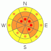
Danger by aspect and elevation on slopes approaching 35° or steeper.
(click HERE for tomorrow's danger rating)
|

Danger Rose Tutorial
|
Ogden area mountains: There are pockets of HIGH danger in the northern parts of the Ogden areas mountains which have received more snow and wind at the upper elevations. The avalanche danger is CONSIDERABLE on all steep, wind drifted slopes. These fresh drifts will be most widespread on northeast through southeast facing slopes. CONSIDERABLE means natural avalanches are possible and human triggered avalanches are likely. Out of the wind drifted terrain, other steep slopes at low, mid and high elevations have a MODERATE danger, for both new snow slides and isolated places where a person could trigger a deep, dangerous slide, failing on weak layers near the ground. |
|
|
CURRENT CONDITIONS |

|
I hope the New Year bring everyone Peace, Health and Hope. The first day of 2010 will certainly be a contrast to yesterday. Clouds quickly obscured the blue moon last night, and temperatures jumped 10 to 15 degrees, with most stations in the low to upper 20’s this morning. The southwesterly winds increased yesterday afternoon and blew through most of the night, with many stations averages 20 to 30 mph, gusting into the 40 and 50’s. Speeds decreased this morning, and currently averages are 20 mph or less. The early morning band of snow moving across northerly Utah has favored the Logan and Odgen mountains with close to ½ inch of snow water equivalent, with light snow just starting in the mountains south of I-80. The new snow is falling on wind slabs, thin sun crusts and low density snow, where I expect “upside down”, inverted conditions. |
|
|
RECENT ACTIVITY |

|
One sizable skier triggered sluff was reported from 8,700’ yesterday, involving new and old, loose faceted snow, in Mill Creek, and explosive work on the Park City ridgeline brought out one soft slab and one hard slab, all on northeasterly facing slopes. A damp soft slab was also triggered with afternoon heating on west. |
|
|
THREAT #1 |

|
| WHERE |
PROBABILITY |
SIZE |
TREND |
|
|
|
|
| |
|
|
Over the next
24 hours.
|
|
|
It could be a tricky day of increasing avalanche danger. Sensitive wind drifts and new snow soft slabs will be the most widespread problem. The denser new snow and wind drifted snow will create a slab above the low density fluff that was widespread yesterday, so I expect easily triggered shallow slides and wind drifts on steep slopes. In some places, slides may take out two storms worth of snow and be triggered from a distance, if they fail on the weak layer of surface hoar and near surface facets. These new snow slides are possible on steep slopes at all elevations, including in the trees and especially avoid terrain traps such as gullies, creek beds and road banks where even shallow slides can pile up snow deeply.
If you are in a place where the snow starts to pile up, winds increase (possible late afternoon), or it starts to rain on the snow, the avalanche danger will quickly increase. |
|
|
THREAT #2 |

|
| WHERE |
PROBABILITY |
SIZE |
TREND |

|
|
|
|
| |
|
|
Over the next
24 hours.
|
|
|
The added weight of the new and wind drifted snow could overload the weak faceted layers near the ground once again, to where they can be triggered by people, a smaller new snow slide or from a distance. Any slide breaking on these lower weak layers would be deep and dangerous. The collapsing heard and felt yesterday at the low and mid elevations in the Ogden mountains is a reminder that weak, basal snow exists at all elevations in the Wasatch mountains – and is most problematic on northwest through north through east facing slopes. |
|
|
MOUNTAIN WEATHER |

|
A weak shortwave is passing through the area this morning ahead of the main trough, which will cross northern Utah tonight. Light snowfall will continue today into early afternoon, when a short break should occur. Snow amounts are forecast to be in the 2 to 5” range, of about 10% density. Temperatures will continue to warm, with highs today near 30 at 8,000’ and in the mid 20’s at 10,000’. The westerly winds will average 10 to 20 mph, with the high ridges averaging 20 to 30 mph, and gusting to 50. An additional 3 to 7 inches of dense snow is forecast to fall overnight and Saturday, with the winds increasing once again Saturday morning. High pressure will build in for Sunday and Monday. |
|
|
GENERAL ANNOUNCEMENTS |
Discount Lift tickets: Ski Utah, Backcountry.com, Alta, Deer Valley, Park City, The Canyons, Wolf Mountain, Snowbasin, Beaver Mountain, Brighton, Sundance, and Solitude have donated a limited number of tickets for sale at discounted prices.
For the Wasatch Powderbird Guides schedule go to their blog
Dawn Patrol Forecast Hotline, updated by 05:30: call 888-999-4019, option 8,
Daily observations are frequently posted by 10 pm each evening.
You can get a free iPhone application from Canyon Sports to display the Bottom Line.
To get a daily avalanche advisory e-mail click HERE.
For a text only version click the upper left link under Search
For canyon closures call UDOT at (801) 975-4838
Send us your avalanche and snow observations. You can also call 801-524-5304 or 800-662-4140, or email to uac@utahavalanchecenter.org
Donate to your favorite non-profit – The Friends of the Utah Avalanche Center. The UAC depends on contributions from users like you to support our work.
The information in this advisory is from the U.S. Forest Service, which is solely responsible for its content. This advisory describes general avalanche conditions and local variations always occur.
Bruce Tremper will update this forecast on Saturday morning. Thanks for calling. |
|
|
This information does not apply to developed ski areas or highways where avalanche control is normally done. This advisory is from the U.S.D.A. Forest Service, which is solely responsible for its content. This advisory describes general avalanche conditions and local variations always occur. |
|
This advisory provided by the USDA Forest Service, in partnership with:
The Friends of the Utah Avalanche Center, Utah Division of State Parks and Recreation, Utah Division of Emergency Management, Salt Lake County, Salt Lake Unified Fire Authority and the friends of the La Sal Avalanche Center. See our Sponsors Page for a complete list. |
