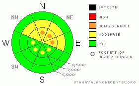
BOTTOM LINE
Danger by aspect and elevation on slopes approaching 35° or steeper.
(click HERE for tomorrow's danger rating)
|
Danger Rose Tutorial
|
The avalanche danger is MODERATE on steep northwest through east facing slopes, at the mid and upper elevations above about 9,000', with pockets of CONSIDERABLE (experts-only) danger on slopes that have not avalanched since the mid December storm. Additionally, yesterday’s brisk northwesterly winds drifted snow, primarily onto the south and east facing slopes, creating a pockety MODERATE danger on steep, wind drifted slopes.
|
|
|
CURRENT CONDITIONS |

|
Under mostly clear skies, temperatures are once again in the chilly single digits this morning at just about all elevations. The northerly winds are much calmer than yesterday, averaging 5 to 10 mph, with speeds across the highest terrain a sedate 15 mph. The place to find the soft, recrystallized powder snow is on the customary shady, sheltered slopes, with widespread sun and wind crusts elsewhere.
|
|
|
RECENT ACTIVITY |

|
There were no reports of backcountry avalanches yesterday, with one shallow soft wind slab triggered on an easterly facing slope with a ski cut from control work. As people travel into less frequented areas, collapsing has still been occurring the past few days.
|
|
|
THREAT #1 |

|
| WHERE |
PROBABILITY |
SIZE |
TREND |
|
|
|
|
| |
|
|
Over the next
24 hours.
|
|
|
The snowpack hasn’t changed much in the last week – any steep, shady slope that hasn’t slid since the mid December storm has a dense layer of snow sitting above weak, sugary faceted crystals. If you do choose to travel on one of these slopes and trigger a slide, it will most likely be 50 to 100’ wide and 2 feet deep, failing near the ground. Don’t under estimate the danger of a slide this size – it can whip you right off your feet, and send you down the slope, fast, and possibly bury you. So it is best to avoid these steep, shady slopes, unless you have the skills to tell that they’ve slid since mid December and not reloaded. There is plentiful lower angle terrain to travel through, just keep a careful eye on slopes angles and aspects, and carefully evaluate all steep terrain features at mid and upper elevations.
|
|
|
THREAT #2 |

|
| WHERE |
PROBABILITY |
SIZE |
TREND |

|
|
|
|
| |
|
|
Over the next
24 hours.
|
|
|
Yesterday’s gusty, northwesterly winds were moving snow around, but didn’t seem to be very efficient when it came to building slabs. Still, along the upper ridgelines, there will be some new, soft and hard drifts, that should be avoided on steep slopes.
|
|
|
MOUNTAIN WEATHER |

|
This morning’s clear skies will become partly cloudy, and occasional snow showers are possible today with no real accumulation. Temperatures will warm into the teens and low 20’s, and the winds will remain light and variable – generally less than 5 mph, with even the high terrain averaging less than 15 mph. Mostly cloudy skies Sunday and Monday, with a few snow flurries possible. Then, starting Tuesday, a series of small disturbances will bring slightly better chances of snow through next week.
|
|
|
GENERAL ANNOUNCEMENTS |
|
Discount Lift tickets: Ski Utah, Backcountry.com, Alta, Deer Valley, Park City, The Canyons, Wolf Mountain, Snowbasin, Beaver Mountain, Brighton, Sundance, and Solitude have donated a limited number of tickets for sale at discounted prices.
For the Wasatch Powderbird Guides schedule go to their blog
Dawn Patrol Forecast Hotline, updated by 05:30: call 888-999-4019, option 8,
Daily observations are frequently posted by 10 pm each evening.
You can get a free iPhone application from Canyon Sports to display the Bottom Line.
To get a daily avalanche advisory e-mail click HERE.
For a text only version click the upper left link under Search
For canyon closures call UDOT at (801) 975-4838
Send us your avalanche and snow observations. You can also call 801-524-5304 or 800-662-4140, or email to uac@utahavalanchecenter.org
Donate to your favorite non-profit – The Friends of the Utah Avalanche Center. The UAC depends on contributions from users like you to support our work.
The information in this advisory is from the U.S. Forest Service, which is solely responsible for its content. This advisory describes general avalanche conditions and local variations always occur.
Brett Kobernik will update this forecast on Sunday morning. Thanks for calling.
|
|
|
This information does not apply to developed ski areas or highways where avalanche control is normally done. This advisory is from the U.S.D.A. Forest Service, which is solely responsible for its content. This advisory describes general avalanche conditions and local variations always occur. |
|
This advisory provided by the USDA Forest Service, in partnership with:
The Friends of the Utah Avalanche Center, Utah Division of State Parks and Recreation, Utah Division of Emergency Management, Salt Lake County, Salt Lake Unified Fire Authority and the friends of the La Sal Avalanche Center. See our Sponsors Page for a complete list. |
