SPECIAL ANNOUNCEMENT |
 |
For a late Christmas present, consider purchasing some ski area lift tickets here from our good friends at Backcountry.com in partnership with Ski Utah. All proceeds benefit the Friends of the Utah Avalanche Center.
Or give the gift of a donation to your favorite charity, the Friends of the Utah Avalanche Center. |
|
|
BOTTOM LINE
Danger by aspect and elevation on slopes approaching 35° or steeper.
(click HERE for tomorrow's danger rating)
|
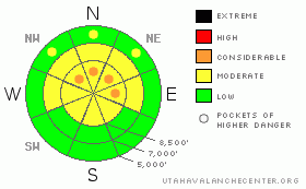
Danger Rose Tutorial
|
The avalanche danger is mostly MODERATE but with pockets of CONSIDERABLE (experts-only) on steep slopes facing north and east quadrants of the compass at mid and upper elevations, especially those that have not avalanched yet. In addition, ridge top winds from the northwest have created wind slabs on downwind terrain. There is a MODERATE danger on any steep, wind drifted slope, which you will find mostly on south through east facing slopes. |
|
|
CURRENT CONDITIONS |

|
My apologies for not writing our traditional Christmas poem but conditions seem too serious for it.
When I got up this morning at 3:00 am, I caught a glimpse of Santa on the neighbor’s roof. He was wearing his down jacket, mittens and face mask because it’s still mighty chilly this morning with temperatures 5-10 degrees in most mountain areas, which is 5 degrees warmer than yesterday morning. Ridge top winds have picked up and are blowing from the northwest at 15 mph on most ridge tops with 20-30 on the highest peaks. You can still find about 6 inches of recrystallized powder on the shady slopes with crusty snow on the sunny aspects. |
|
|
RECENT ACTIVITY |

|
For a change, there was no avalanche activity reported from the backcountry yesterday but there were a couple skier triggered avalanches from two day ago. We have more information and photos on those slides including my investigation of the Willows slide in Current Conditions. Yesterday, one backcountry skier was still reporting large collapsing and one Park City resort was still producing medium to large avalanches with explosives in unskied terrain. |
|
|
THREAT #1 |

|
| WHERE |
PROBABILITY |
SIZE |
TREND |

|
|
|
|
| |
|
|
Over the next
24 hours.
|
|
|
From my informal polling of all the cagy avalanche professionals, they are all still avoiding the steep slopes that have not slid during the big storm 10 days ago, on slopes that face the north and east quadrants of the compass. The pucker factor is just too high. Depending on where you are, somewhere between 10-30 percent of slopes did not slide during the big storm and they can easily shatter like glass with the weight of a person. They will be large avalanches, about 2 feet deep and quite dangerous. Plus, it’s very difficult to tell the difference between safe and dangerous slopes, even if you are an experienced professional. So avoidance is still the best option. We always struggle with what to call these conditions because the standard, international definitions just don’t work. In the past, we have called it a “Scary Moderate” and I think we should resurrect this term again. It means low probability and high consequences. On our danger rose, we all agree it’s mostly Moderate with pockets of Considerable. The overall danger rating for the region is right on the border between Moderate and Considerable, but I will defer to the higher rating in this case because of the large avalanche size and tricky conditions. Considerable means experts-only. |
|
|
THREAT #2 |

|
| WHERE |
PROBABILITY |
SIZE |
TREND |

|
|
|
|
| |
|
|
Over the next
24 hours.
|
|
|
Northwest winds have created some wind slabs, mostly along the upper elevation ridges. As always, avoid any steep slopes with recent deposits of wind drifted snow. |
|
|
MOUNTAIN WEATHER |

|
Today we should have partly to mostly cloudy skies as a weak disturbance drifts down from the north. Temperatures should remain cold at 5-10 deg along the ridges and in the teens down at 8,000’. We may get a few light snow flurries today but no significant accumulation. Tomorrow, we should have partly cloudy skies with a little warmer temperatures.
In the extended forecast, we have a chance for more snow in about a week. |
|
|
GENERAL ANNOUNCEMENTS |
Discount Lift tickets: Ski Utah, Backcountry.com, Alta, Deer Valley, Park City, The Canyons, Wolf Mountain, Snowbasin, Beaver Mountain, Brighton, Sundance, and Solitude have donated a limited number of tickets for sale at discounted prices.
For the Wasatch Powderbird Guides schedule go to their blog
Dawn Patrol Forecast Hotline, updated by 05:30: call 888-999-4019, option 8,
Daily observations are frequently posted by 10 pm each evening.
You can get a free iPhone application from Canyon Sports to display the Bottom Line.
To get a daily avalanche advisory e-mail click HERE.
For a text only version click the upper left link under Search
For canyon closures call UDOT at (801) 975-4838
Send us your avalanche and snow observations. You can also call 801-524-5304 or 800-662-4140, or email to uac@utahavalanchecenter.org
Donate to your favorite non-profit – The Friends of the Utah Avalanche Center. The UAC depends on contributions from users like you to support our work.
The information in this advisory is from the U.S. Forest Service, which is solely responsible for its content. This advisory describes general avalanche conditions and local variations always occur.
Evelyn Lees will update this forecast on Saturday morning. Thanks for calling. |
|
|
This information does not apply to developed ski areas or highways where avalanche control is normally done. This advisory is from the U.S.D.A. Forest Service, which is solely responsible for its content. This advisory describes general avalanche conditions and local variations always occur. |
|
This advisory provided by the USDA Forest Service, in partnership with:
The Friends of the Utah Avalanche Center, Utah Division of State Parks and Recreation, Utah Division of Emergency Management, Salt Lake County, Salt Lake Unified Fire Authority and the friends of the La Sal Avalanche Center. See our Sponsors Page for a complete list. |
