AVALANCHE WATCH »
The risk of an avalanche is expected to increase significantly
but the timing and location are still uncertain. Stay tuned for updates.
|
 |
Notice: An Avalanche Watch has been issued for the mountains of Utah, including the Logan area mountains, Wasatch mountains, Central and Southern Utah mountains and the Western Uinta mountains. A series of storms is increasing the avalanche danger today, and with more snow and wind, very dangerous avalanche conditions are expected Saturday night and Sunday. |
|
|
BOTTOM LINE
Danger by aspect and elevation on slopes approaching 35° or steeper.
(click HERE for tomorrow's danger rating)
|
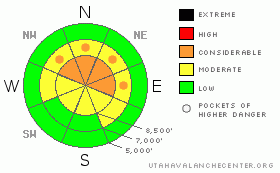
Danger Rose Tutorial
|
The avalanche danger is CONSIDERABLE on steep, wind drifted slopes facing northwest through north though east, at mid and upper elevations. Both loose snow sluffs and slab avalanches will be easy to trigger, especially in wind drifted areas. Avalanches triggered from a distance, so avoid travel below steep slopes. On low angle slopes and the rocky, south facing slopes, the avalanche danger is generally LOW.
|
|
|
CURRENT CONDITIONS |

|
A moist, southwest flow has kicked off a round of light snow in the mountains and warmed temperatures into the mid teens to low 20’s. New snow amounts in the Ogden area mountains are in the 2 to 4” range as of 6 am. Overnight, the winds kicked up, and the Ogden stations favored by southwest flow had hourly averages of 30 to 40 mph, with gusts in the 50's. Wind speeds have decreased this morning, and most stations are averaging closer to 20mph.
|
|
|
RECENT ACTIVITY |

|
Very few observations yesterday, but a party walking the ridge above West Monitor on the Park City ridge line triggered a large collapse, with the slope below cracking, but not steep enough to move.
Today is a day of increasing avalanche danger. As a series of storms and strong winds overload the fragile preexisting snowpack, the avalanche danger will steadily rise throughout the weekend, and this is a tricky time when avalanche accidents often occur.
|
|
|
THREAT #1 |

|
| WHERE |
PROBABILITY |
SIZE |
TREND |

|
|
|
|
| |
|
|
Over the next
24 hours.
|
|
|
The most dangerous slopes today will be upper and mid elevation shady slopes that had old snow on the ground. On these steep slopes, the fresh drifts of windblown snow are sitting on a variety of soft and hard old snow surfaces, which overlie weak faceted snow. Slab avalanches will be easy to trigger, and slides could break into the old snow today, and be 1 to 2’ deep. Cracking and collapsing are warning signs that the snowpack is unstable. Slides can be triggered from a distance today and from lower angle slopes, so avoid travel below and adjacent to steep slopes.
|
|
|
THREAT #2 |

|
| WHERE |
PROBABILITY |
SIZE |
TREND |

|
|
|
|
| |
|
|
Over the next
24 hours.
|
|
|
In wind sheltered areas, loose snow sluffs will be possible, both within the new snow and gouging into loose sugary snow. These sluffs could pick up significant volume and pack a punch in continuously steep terrain, especially if there’s a slick crust beneath.
|
|
|
MOUNTAIN WEATHER |

|
A moist, mild flow will usher in a series of storms today through Monday, with the most potent storm period late tonight through Sunday. Today, light snow should continue for a few more hours this morning, followed by a break. Snow will redevelop early this afternoon, and snow totals of 3 to 8” are possible by this evening, with locally heavier amounts in areas favored by southwest flow. High temperatures today will be in the mid to upper 20’s, lows tonight in the teens and low 20’s. The southwesterly winds will be in the 10 to 20 mph range today, with gusts in the 20’s and 30’s. Winds will increase once again tonight, and heavy snowfall should be occurring by morning. An additional 6 to 10 inches of snow is possible tonight, and again on Sunday. Storm total by Monday morning could be in the 18 to 30” range.
|
|
|
GENERAL ANNOUNCEMENTS |
|
We are recording our early morning phone line, (1-888-999-4019, option 8), with avalanche information, by 5:30 am – it’s a good source for dawn patrollers. Also, many of the day’s observations are posted on line under Current Conditions by 10 pm each evening.
Pro Riders Workshop at Snowbird The Utah Avalanche Center and Snowbird Ski and Summer Resort are partnering to offer the first annual Freeride Avalanche Summit, Dec.17-18. The two-day clinic targets advanced and expert skiers and riders who want practical and professional instruction on avalanche awareness, safety and rescue. The Freeride Avalanche Summit includes a unique blend of instruction that combines the expertise of industry leading avalanche forecasters with the experience and influence of local, professional athletes. Click here for more info and to register- http://www.snowbird.com/freerideavalanchesummit.html
Our web site is now formatted for iPhone. You can also download a free iPhone application from Canyon Sports to display the Bottom Line. Search for Utah Avalanche on the Apple's iPhone Apps page or in iTunes.
If you want to get this avalanche advisory e-mailed to you daily click HERE.
For a text only version, the link is on the left side bar, near the top.
UDOT highway avalanche control work info can be found by calling (801) 975-4838. Our statewide toll free line is 1-888-999-4019 (early morning, option 8).
Donate to your favorite non-profit – The Friends of the Utah Avalanche Center. The UAC depends on contributions from users like you to support our work. To find out more about how you can support our efforts to continue providing the avalanche forecasting and education that you expect please visitour Friends page.
We appreciate avalanche and snow observations. If there’s something we should know about give us a call at (801) 524-5304 or 1-800-662-4140, or email us at uac@utahavalanchecenter.org. (Fax 801-524-6301).
The information in this advisory is from the U.S. Forest Service, which is solely responsible for its content. This advisory describes general avalanche conditions and local variations always occur.
Brett Kobernik will update this forecast on Sunday morning. And thanks for calling.
|
|
|
This information does not apply to developed ski areas or highways where avalanche control is normally done. This advisory is from the U.S.D.A. Forest Service, which is solely responsible for its content. This advisory describes general avalanche conditions and local variations always occur. |
|
This advisory provided by the USDA Forest Service, in partnership with:
The Friends of the Utah Avalanche Center, Utah Division of State Parks and Recreation, Utah Division of Emergency Management, Salt Lake County, Salt Lake Unified Fire Authority and the friends of the La Sal Avalanche Center. See our Sponsors Page for a complete list. |
