SPECIAL ANNOUNCEMENT |
 |
We are recording our early morning phone line,(1-888-999-4019, option 8), with avalanche information, by 5:30 am – it’s a good source for dawn patrollers. Also, many of the day’s observations are posted on line under Current Conditions by 10 pm each evening.
Pro Riders Workshop at Snowbird The Utah Avalanche Center and Snowbird Ski and Summer Resort are partnering to offer the first annual Freeride Avalanche Summit, Dec. 17-18. The two-day clinic targets advanced and expert skiers and riders who want practical and professional instruction on avalanche awareness, safety and rescue. The Freeride Avalanche Summit includes a unique blend of instruction that combines the expertise of industry leading avalanche forecasters with the experience and influence of local, professional athletes. Click here for more info and to register- http://www.snowbird.com/freerideavalanchesummit.html |
|
|
BOTTOM LINE
Danger by aspect and elevation on slopes approaching 35° or steeper.
(click HERE for tomorrow's danger rating)
|
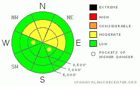
Danger Rose Tutorial
|
The avalanche danger is MODERATE on steep, wind drifted slopes facing north though east, above about 9,500’. Avalanches will be easy to trigger but probably soft and about a foot deep. Out of wind affected terrain, on south facing slopes and lower angle slopes, avalanche danger is generally LOW. But be aware of what you are connected to – avoid travel directly below or adjacent to steeper slopes. The danger in the Provo area mountains continues to be CONSIDERABLE where much more snow fell from the last storm. |
|
|
CURRENT CONDITIONS |

|
Temperatures continue to climb and they are much more reasonable this morning than the last few mornings. At least they are above zero. (See the charts) At higher elevations, the milder air is pushing in and warming temps up to a balmy 10-15 degrees, while in the mountain valleys, it’s still near zero. Skies are clear.
The snowpack is still a real junk show with very thin, punchy snow as you continuously fall through into astoundingly weak depth hoar before you bottom out on the rocks. It’s only about 1-2 feet deep in upper elevation shady slopes and you have to pick your routes very carefully. Resorts and groomed roads are the best choice. South facing slopes have just a skiff over rocks. Many people have been injured this season including a friend of mine with a hip-to-knee, black-and-blue contusion. So be careful.
But this is all going to change in a hurry this weekend…. |
|
|
RECENT ACTIVITY |

|
The string of human triggered avalanches continued yesterday in the Salt Lake area mountains, specifically along the Park City ridgeline near Guardsman’s pass when one person stomped on the ridge and only later noticed that a 30’ wide slide pulled out down off the ridge. Most of the slides these past days were 1 to 1 ½ feet deep, and pockety, less than 50’ wide. Others include Rocky Point, Pioneer Ridge and Silver Fork. Most of the slides were on north to northeasterly facing slopes, above about 10,000’. Remotely triggered slides were reported as well. I still experienced several large, scary collapses yesterday. You can find many photos and snow pit profiles are posted in Current Conditions. |
|
|
THREAT #1 |

|
| WHERE |
PROBABILITY |
SIZE |
TREND |
|
|
|
|
| |
|
|
Over the next
24 hours.
|
|
|
All the avalanche professionals in the Wasatch have exhausted their extensive vocabulary in describing the astoundingly weak qualities our thin excuse of a snowpack. Even sluffs are gouging down to the ground and the folks at Alta have called them deep sluff avalanches. Any place that has a slab on it, you just have to sneeze on it and it all shatters. Many avalanches are breaking mid slope, as is typical of depth hoar.
The big news is that it looks like we will have the first “real” storm of the season this weekend with 2-3 inches of water weight and hopefully 2-3 feet of snow to wash all our troubles away. Yahoo! We will likely run avalanche warnings for Saturday night through Monday. |
|
|
MOUNTAIN WEATHER |

|
Today should be the last, nice, sunny day with warm temperatures and light winds. The big weekend storm will get started Saturday afternoon with increasing southwest ridgetop winds, clouds and some light snow showers. The hammer will come down on Sunday and last into Monday with very strong southwest to west winds and 2 feet of snow—perhaps 3 feet in favored areas. Temperatures should start out in the mid 20’s at the start of the storm then drop into the teens at the end. |
|
|
GENERAL ANNOUNCEMENTS |
Our web site is now formatted for iPhone. You can also download a free iPhone application from Canyon Sports to display the Bottom Line. Search for Utah Avalanche on the Apple's iPhone Apps page or in iTunes.
If you want to get this avalanche advisory e-mailed to you daily click HERE.
For a text only version, the link is on the left side bar, near the top.
UDOT highway avalanche control work info can be found by calling (801) 975-4838. Our statewide toll free line is 1-888-999-4019 (early morning, option 8).
Donate to your favorite non-profit – The Friends of the Utah Avalanche Center. The UAC depends on contributions from users like you to support our work. To find out more about how you can support our efforts to continue providing the avalanche forecasting and education that you expect please visitour Friends page.
We appreciate avalanche and snow observations. If there’s something we should know about give us a call at (801) 524-5304 or 1-800-662-4140, or email us at uac@utahavalanchecenter.org. (Fax 801-524-6301).
The information in this advisory is from the U.S. Forest Service, which is solely responsible for its content. This advisory describes general avalanche conditions and local variations always occur.
Evelyn Lees will update this forecast Saturday morning. |
|
|
This information does not apply to developed ski areas or highways where avalanche control is normally done. This advisory is from the U.S.D.A. Forest Service, which is solely responsible for its content. This advisory describes general avalanche conditions and local variations always occur. |
|
This advisory provided by the USDA Forest Service, in partnership with:
The Friends of the Utah Avalanche Center, Utah Division of State Parks and Recreation, Utah Division of Emergency Management, Salt Lake County, Salt Lake Unified Fire Authority and the friends of the La Sal Avalanche Center. See our Sponsors Page for a complete list. |
