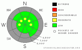
BOTTOM LINE
Danger by aspect and elevation on slopes approaching 35° or steeper.
(click HERE for tomorrow's danger rating)
|
Danger Rose Tutorial
|
It remains mostly LOW with pockets of MODERATE danger in areas that receive the most amount of snow. If more get more snow and wind than forecast, the danger will run accordingly. Watch for changing conditions over the next couple of days. For now, minor sluffing and shallow human triggered avalanches will be possible with the accumulations over the next day or so. The danger is reaching toward CONSIDERABLE in Provo mountains, with naturals likely with the heavier snowfall. |
|
|
CURRENT CONDITIONS |

|
We’re seeing the first few inches of light density snow from what looks to be more of a Wasatch Plateau/Southern Utah special. In the north, however, 3-5” of snow blankets terrain favored by a southwesterly flow (Ogden, the Park City mountains, upper Big Cottonwood), but the crosshairs are clearly aligned over Provo canyon and Sundance. They’ve received more than a foot of new overnight and it’s still snowing. Densities are reported to be extremely low – even in the 3-5% range, and I’d imagine anything more than a whisper of wind would get the snow to move. Unfortunately, the anemometers are showing more than a whisper – they too picked up overnight and are blowing 15-20mph from the southwest, with the higher stations showing speeds of 20-30mph with gusts to 40. Temps are in the low teens and upper single digits.
Riding conditions remain thin and threadbare and relegated to the upper elevation east, north and westerly facing slopes. Before you pull the plastic on the new boards, remember that snow this light is mostly air – you’ll bottom out on the same rocks and deadfall as last week. As the Provo UDOT forecaster Craig Patterson put it this morning – looking out at the 16” of 4% there in front of his shed in the canyon, “If we had a base, this is what dreams would be made of.” |
|
|
RECENT ACTIVITY |

|
The only activity we heard about was in the Logan area mountains where two riders unintentionally triggered 12” deep and 20’ wide soft slabs, with one going for a short ride. Our forecaster in Logan has some good photos - check out our Current Conditions page for more details and other observations from the backcountry, including my clumsy maiden voyage into the world of youtube. (Lower your expectations) |
|
|
THREAT #1 |

|
| WHERE |
PROBABILITY |
SIZE |
TREND |
|
|
|
|
| |
|
|
Over the next
24 hours.
|
|
|
Sluffing and shallow, very light wind drifts will be the problems of the day. While we have an exceedingly weak snowpack, I don’t think that the new weight will be enough to tip the balance. This may not be the case in the alpine terrain of the Provo mountains. They’ll likely natural sluffing in the low densities with the potential for them to hovercraft farther than usual on some of the older hard wind crusts, as they’ll be contained only by the roughness and irregularity of the early season coverage.
Along the higher ridgelines, watch for sensitive shallow wind drifts – they should easily crack out under the weight of a person, and will be more pronounced in the steep, upper elevation north through easterly facing slopes.
|
|
|
MOUNTAIN WEATHER |

|
A Pacific storm off to the west is ladelling in moisture on a southwest flow. Snow amounts will be difficult to forecast, but I would imagine another 3-8” with perhaps twice that for the southern Wasatch. The storm should continue tonight into tomorrow. Winds are expected to drop off and blow just 10-15mph from the southwest. Temps will be in the low teens and upper single digits. As the storm moves east tomorrow, the winds will veer to the northwest, favoring the Cottonwoods. A moist westerly flow follows for the remainder of the week. |
|
|
GENERAL ANNOUNCEMENTS |
The NWS has a slick new snow webpage - check it out here.
Our web site is now formatted for iPhone. You can also download a free iPhone application from Canyon Sports to display the Bottom Line. Search for Utah Avalanche on the Apple's iPhone Apps page or in iTunes.
If you want to get this avalanche advisory e-mailed to you daily click HERE.
For a text only version, the link is on the left side bar, near the top.
UDOT highway avalanche control work info can be found by calling (801) 975-4838. Our statewide toll free line is 1-888-999-4019 (early morning, option 8).
Donate to your favorite non-profit – The Friends of the Utah Avalanche Center. The UAC depends on contributions from users like you to support our work. To find out more about how you can support our efforts to continue providing the avalanche forecasting and education that you expect please visitour Friends page.
We appreciate avalanche and snow observations. If there’s something we should know about give us a call at (801) 524-5304 or 1-800-662-4140, or email us at uac@utahavalanchecenter.org. (Fax 801-524-6301).
The information in this advisory is from the U.S. Forest Service, which is solely responsible for its content. This advisory describes general avalanche conditions and local variations always occur.
I will update this forecast tomorrow. And thanks for calling. |
|
|
This information does not apply to developed ski areas or highways where avalanche control is normally done. This advisory is from the U.S.D.A. Forest Service, which is solely responsible for its content. This advisory describes general avalanche conditions and local variations always occur. |
|
This advisory provided by the USDA Forest Service, in partnership with:
The Friends of the Utah Avalanche Center, Utah Division of State Parks and Recreation, Utah Division of Emergency Management, Salt Lake County, Salt Lake Unified Fire Authority and the friends of the La Sal Avalanche Center. See our Sponsors Page for a complete list. |
