SPECIAL ANNOUNCEMENT |
 |
We will be issuing intermittent avalanche advisories for the rest of the season. We will likely issue advisories each afternoon this week through the storm cycle, and then go back to more intermittent advisories as the avalanche conditions stabilize. |
|
|
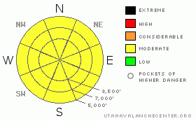
BOTTOM LINE
Danger by aspect and elevation on slopes approaching 35° or steeper.
(click HERE for tomorrow's danger rating)
|
Danger Rose Tutorial
|
The avalanche danger is MODERATE on slopes of about 35 degrees and steeper, for triggering slab avalanches and sluffs within the new snow. The wind drifted slopes will be the most sensitive. During periods of intense precipitation, the snow will be extremely sensitive, and the danger could briefly rise to CONSIDERABLE, with natural avalanches possible. Below about 8,500’, the avalanche danger is MODERATE for wet loose sluffs and slabs, which could be triggered by a person on steep slopes. |
|
|
CURRENT CONDITIONS |

|
An unusual southeasterly flow is just stacking up the snow – the upper Cottonwoods and Park City ridgeline now have about 18 to 36” of snow since the storm started on Tuesday the 14th, with water equivalents of 2 to 4”. The Ogden and Provo area mountains have received about a foot of new snow at the 8,000’ level, and one would suspect the upper elevation terrain of the Provo area mountains would have 2 to 3 feet of new snow. Temperatures are on a downward trend, in the low to mid 20s at most elevations. The winds are still from the southeast this evening, and have dropped from today’s speeds of 25 to 35 mph, down to generally less than 15 mph. Today’s strangely dense snow made for enjoyable maritime-like turning and riding conditions. |
|
|
RECENT ACTIVITY |

|
Reports from the backcountry Wednesday include both naturals and skier triggered slides, of new snow only. Most were on north and easterly facing slopes, about 50’ wide by 10” deep, though one near Mary’s Lake in upper Big Cottonwood was about 250’ wide. With the extra kick of explosives, the Cottonwood resorts were getting much larger, long running, high volume slides on all aspects. There was also a wet slab triggered with explosives on a northwest facing slope at 8,500’ that failed on wet basal facets that was 3 feet deep by 150’ wide. |
|
|
THREAT #1 |

|
| WHERE |
PROBABILITY |
SIZE |
TREND |

|
|
|
|
| |
|
|
Over the next
24 hours.
|
|
|
With an additional 6 to 14” of snow possible in the Ogden area mountains by late on Thursday, it will continue to be possible for a person to trigger slab avalanches and sluffs within the newest snow. This lighter snow will be most sensitive anywhere it is wind drifted, and also during periods of high snowfall rates. Anytime it starts snowing harder than an inch an hour, the snow could become very unstable, and a natural avalanche cycle could occur. I expect most of the warm snow from Tuesday and Wednesday to settle and strengthen rapidly, but there may be a few spots on steep slopes where a slide triggered in the newest snow could step down, taking out the whole storm, to a depth of 2 feet or more. Cornices along the high ridge lines remain sensitive. |
|
|
THREAT #2 |

|
| WHERE |
PROBABILITY |
SIZE |
TREND |

|
|
|
|
| |
|
|
Over the next
24 hours.
|
|
|
At the lower elevations, the new snow has insulated the wet, rain soaked snow pack. The old snow on the ground will be very slow to cool and refreeze, and the new snow will be damp and sloppy. It will be possible for a person to trigger new snow wet, loose sluffs below about 8,500’, and in very steep terrain have the wet snow fail near the ground. Avoid the steep, low elevation slopes, especially terrain traps such as gullies, creek bottoms and flats below steep road banks. |
|
|
MOUNTAIN WEATHER |

|
A slow moving low pressure system will continue to affect northern Utah through Friday morning. After a bit of a lull in the action this evening, snowfall will become more steady and heavier later tonight. Another 3 to 8” of light powder is possible by morning as the flow turns more northerly and similar amounts are forecast again for tomorrow. The north to northeasterly winds will be in the 10 to 20 mph range, with gusts to 30. The highest ridgelines will have average speeds to 25, with gusts in the 40s. Temperatures will be much cooler, in the teens and twenties. A strong ridge of high pressure will move in for the weekend, with plenty of sunshine and significantly warmer temperatures. |
|
|
GENERAL ANNOUNCEMENTS |
We will be issuing intermittent avalanche advisories for the rest of the season. We will likely issue advisories each afternoon this week through the storm cycle, and then go back to more intermittent advisories as the avalanche conditions stabilize.
Our web site is now formatted for iPhone. You can also download a free iPhone application from Canyon Sports to display the Bottom Line. Search for Utah Avalanche on the Apple's iPhone Apps page or in iTunes.
If you want to get this avalanche advisory e-mailed to you daily click HERE.
For a text only version, the link is on the left side bar, near the top.
UDOT highway avalanche control work info can be found by calling (801) 975-4838. Our statewide toll free line is 1-888-999-4019 (early morning, option 8).
Donate to your favorite non-profit – The Friends of the Utah Avalanche Center. The UAC depends on contributions from users like you to support our work. To find out more about how you can support our efforts to continue providing the avalanche forecasting and education that you expect please visitour Friends page.
We appreciate any and all late season avalanche and snow observations, so keep them coming!! Please leave us a message at (801) 524-5304 or 1-800-662-4140, or email us at uac@utahavalanchecenter.org. (Fax 801-524-6301).
The information in this advisory is from the U.S. Forest Service, which is solely responsible for its content. This advisory describes general avalanche conditions and local variations always occur.
Bruce will update this advisory tomorrow afternoon, Thursday April 16th. |
|
|
This information does not apply to developed ski areas or highways where avalanche control is normally done. This advisory is from the U.S.D.A. Forest Service, which is solely responsible for its content. This advisory describes general avalanche conditions and local variations always occur. |
|
This advisory provided by the USDA Forest Service, in partnership with:
The Friends of the Utah Avalanche Center, Utah Division of State Parks and Recreation, Utah Division of Emergency Management, Salt Lake County, Salt Lake Unified Fire Authority and the friends of the La Sal Avalanche Center. See our Sponsors Page for a complete list. |
