SPECIAL ANNOUNCEMENT |
 |
We will be issuing intermittent avalanche advisories for the rest of the season as conditions change. We will likely issue advisories each afternoon this week to keep you up to date on the storm and then they will become more intermittent as conditions stabilize. |
|
|
BOTTOM LINE
Danger by aspect and elevation on slopes approaching 35° or steeper.
(click HERE for tomorrow's danger rating)
|
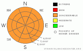
Danger Rose Tutorial
|
With additional wind, rain and snow, the avalanche danger will continue to rise tonight through Wednesday. The danger is CONSIDERABLE on slopes steeper than about 35 degrees, for both for new snow slides and sensitive drifts of windblown snow. CONSIDERABLE means that human triggered slides are probable and natural avalanches possible. The danger may rise to HIGH during the periods of intense precipitation that are forecast to occur midday Wednesday, with a natural avalanche cycle possible. With continued rain, the danger for wet loose sluffs at mid and low elevation terrain is CONSIDERABLE. |
|
|
CURRENT CONDITIONS |

|
It was one of those unfortunate plastic garbage bag days, with a moist southwesterly flow producing both mountain rain and snow, with the rain/snow line struggling to remain at 8,000 to 8,500’. As of 6 pm tonight, snow totals are in the 8 to 12” range in the upper elevations of the Cottonwoods and Park City ridgeline, with about half that in the Ogden and Provo area mountains. Densities are around 10% at the higher elevations, with much of the terrain at and below 8,000’ receiving ½ to 1 ½” of rain. Mid elevation snow was the consistency of wet mashed potatoes, but consistency improved with elevation. Cooler temperatures will steadily improve conditions Wednesday, Thursday and Friday, creating one last wonderful powder blast. Southwesterly winds have been in the 15 to 25 mph range along the ridge lines, with gusts 35 to 45 mph. 10,000’ temperatures are in the upper 20’s to low 30’s. Check for current snow totals Wednesday morning HERE. |
|
|
RECENT ACTIVITY |

|
Reports from today were of easily triggered soft slabs and loose sluffs at the higher elevations, including a small natural cycle in upper Little Cottonwood this morning. Wet loose sluffs were triggered just above and below the rain line. |
|
|
THREAT #1 |

|
| WHERE |
PROBABILITY |
SIZE |
TREND |

|
|
|
|
| |
|
|
Over the next
24 hours.
|
|
|
With significant additional snow on the way, the avalanche danger will increase tonight and tomorrow. An additional 8 to 20” of snow is possible by tomorrow night, and both sluffs and slab avalanches will occur on steep slopes. The southerly winds will be drifting the snow into sensitive slabs on the northerly facing slopes, and drifts will be cross loaded into other terrain as well. Anytime there are high snowfall rates, the avalanche danger will jump, with both natural and human-triggered avalanches occurring within the new snow. The heaviest snowfall rates will be during frontal passage, forecast for mid day tomorrow. And finally, watch for weak layers that may develop within the new snow such as graupel or low density layers. Jump on small test slopes and dig down with your hand to see how well the snow is bonded to the old crusts and within the new layers. Backcountry travelers tomorrow should have avalanche experience and use conservative decision making. |
|
|
THREAT #2 |

|
| WHERE |
PROBABILITY |
SIZE |
TREND |

|
|
|
|
| |
|
|
Over the next
24 hours.
|
|
|
The rain/snow will lower very slowly, from near 8,500’ this evening to around 7000’ by tomorrow afternoon. With the mid and lower elevations receiving substantial rain, it will continue to be possible to trigger wet loose sluffs on any steep slopes with old snow. Especially avoid terrain where you could be pushed into a terrain trap - such as a gully, below a road bank or into a creek bed – where snow could pile up deeply. Even as the surface snow finally cools and forms a crust, be aware that the wet snow beneath may still act as a weak layer, and shallow slabs could be triggered. |
|
|
MOUNTAIN WEATHER |

|
A slow moving storm complex will affect the mountains of northern Utah through at least Thursday night. Strong southerly winds will continue tonight and tomorrow morning, with periods of intermittent snow, heavy at times. 5 to 10” of snow possible tonight, with another 5 to 10” possible tomorrow. Tonight, the southerly winds will average 15 to 25 mph at the 10,000’ level, and 30 to 40 mph across the higher ridges, with gusts in the 60’s. Winds will shift to the southwest tomorrow, and decrease slightly. Temperatures will cool into the 20s at 10,000’ and the low 30s at 8,000’. Snow should continue well into Thursday, on a cooler, northerly wrap around flow. Be sure to monitor the National Weather Service web site to follow the storm’s progress (use the links on our Weather page). |
|
|
GENERAL ANNOUNCEMENTS |
We will be issuing intermittent avalanche advisories for the rest of the season as conditions change. We will likely issue advisories each afternoon this week to keep you up to date on the expected snowstorm and then they will become more intermittent as conditions stabilize.
Our web site is now formatted for iPhone. You can also download a free iPhone application from Canyon Sports to display the Bottom Line. Search for Utah Avalanche on the Apple's iPhone Apps page or in iTunes.
If you want to get this avalanche advisory e-mailed to you daily click HERE.
For a text only version, the link is on the left side bar, near the top.
UDOT highway avalanche control work info can be found by calling (801) 975-4838. Our statewide toll free line is 1-888-999-4019 (early morning, option 8).
Donate to your favorite non-profit – The Friends of the Utah Avalanche Center. The UAC depends on contributions from users like you to support our work. To find out more about how you can support our efforts to continue providing the avalanche forecasting and education that you expect please visitour Friends page.
We appreciate any and all late season avalanche and snow observations, so keep them coming! Leave us a message at (801) 524-5304 or 1-800-662-4140, or email us at uac@utahavalanchecenter.org. (Fax 801-524-6301).
The information in this advisory is from the U.S. Forest Service, which is solely responsible for its content. This advisory describes general avalanche conditions and local variations always occur.
We will update this advisory on Wednesday. |
|
|
This information does not apply to developed ski areas or highways where avalanche control is normally done. This advisory is from the U.S.D.A. Forest Service, which is solely responsible for its content. This advisory describes general avalanche conditions and local variations always occur. |
|
This advisory provided by the USDA Forest Service, in partnership with:
The Friends of the Utah Avalanche Center, Utah Division of State Parks and Recreation, Utah Division of Emergency Management, Salt Lake County, Salt Lake Unified Fire Authority and the friends of the La Sal Avalanche Center. See our Sponsors Page for a complete list. |
