AVALANCHE WARNING »
Dangerous avalanche conditions are occuring or are imminent.
Backcountry travel in avalanche terrain is not recommended.
|
 |
Notice: The Avalanche Warning has been expanded to include all the Wasatch mountains from the Idaho border south to US route 6. Two to three feet of new snow and strong winds have created a HIGH avalanche danger. Both natural and human triggered avalanches are certain on steep slopes. Travel in avalanche terrain is not recommended. |
|
|
BOTTOM LINE
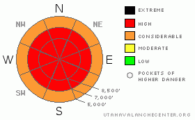
Danger by aspect and elevation on slopes approaching 35° or steeper.
(click HERE for tomorrow's danger rating)
|
Danger Rose Tutorial
|
The avalanche danger is HIGH today, (with pockets of Extreme in the Cottonwood Canyons). Natural avalanches are occurring this morning, and human triggered avalanches are certain in steep terrain today. If you choose to travel in the backcountry today, extensive avalanche training, experience and knowledge are essential. Avoid travel on and below steep avalanche terrain and travel only on gentle slopes well away from areas affected by avalanches. |
|
|
CURRENT CONDITIONS |

|
This could be the stormiest week of the winter…the mountains are getting slammed, with 48 hour storm totals alone pushing 3 feet in the Cottonwoods, two feet in the Ogden and Park City mountains, and up to 18” at the mid elevations of the Provo mountains. Water equivalents of 3” are common. Many of the 7,500’ to 8,500 foot SNOTEL sites such as Parley’s and Lookout Mountain have received about a foot of snow with over 2 inches of water weight. The most recent overnight snow is warmer, with densities running 10% to 13% at many locations. Combined with wind damage at most elevation, it’s “upside down”. Temperatures are in the teens and dropping. The northwesterly winds are averaging 10 to 20 mph, with gusts in the 30’s and 40’s at most locations. Across the highest terrain, averages are in the 30s with gusts in the 50’s and 60’s. |
|
|
RECENT ACTIVITY |

|
Yesterday, one to two foot deep soft slabs were easily triggered in the backcountry on steep slopes, up to 250' wide, especially in wind affected terrain. They were running within Monday’s storm, about 4" above the upper dirt layer. At the resorts, explosives and ski cuts released soft slabs, some with deep debris piles. Conditions were also very sensitive in the Ogden area mountains, with slides remotely triggered from as far as 200’ away, and a few very large slides released with explosives in upper elevation terrain. Natural avalanche activity continued overnight, with slides logged in Little Cottonwood Canyon on the steep southerly facing slopes above the highway early this morning. |
|
|
THREAT #1 |

|
| WHERE |
PROBABILITY |
SIZE |
TREND |

|
|
|
|
| |
|
|
Over the next
12 hours.
|
|
|
The avalanche danger will remain high today. There are several new snow weak layers, now overloaded with 1 to 3 feet of heavier, dense windblown snow. The gusty winds have reached down into the mid and lower elevation terrain, so be on the lookout for drifts at all elevations. Today, slides 1 to 3 feet deep can be triggered from a distance or from lower angle terrain that is adjacent to steeper terrain, which may then pull out the lower angle slope. Cornices are fragile and can break back further than expected. Low to mid elevations have gotten substantial snow and water amounts, too, and slides may release down to the old hard crusts at the lower elevations.
With deep, “upside down” snow, movement stopping wind drifts and hard trail breaking, it will be a tough day for backcountry skiing, and ski resorts will be an excellent option. |
|
|
MOUNTAIN WEATHER |

|
A moist, northwest flow over northern Utah will keep snow continuing for most of the day, locally heavy at times through about noon. 4 to 7 additional inches are expected, with locally heavier amounts possible. The gusty northwesterly winds are in the slow process of shifting to the north, and will gradually decrease throughout the day. Temperatures will be in the single digits to low teens today. There will be a break tonight through Saturday, with partly cloudy skies and warming temperatures. The hydrologists might be cracking a smile as the models show several more storms lined up to hit northern Utah, with the first on Sunday. |
|
|
GENERAL ANNOUNCEMENTS |
Wasatch Powderbird Guides did not fly yesterday and will not fly today. Check their operations planning page is here.
Our web site is now formatted for iPhone. You can also download a free iPhone application from Canyon Sports to display the Bottom Line. Search for Utah Avalanche on the Apple's iPhone Apps page or in iTunes.
Beacon training parks are up and running! There is one at Snowbasin, one on the Park City side at the top of Canyon’s gondola toward the Tombstone lift, one in Little Cottonwood near the Snowbird parking structure on the bypass road, and in Big Cottonwood a training park is at the west end of Solitude's lower parking lot.
If you want to get this avalanche advisory e-mailed to you daily click HERE.
For a text only version, the link is on the left side bar, near the top.
UDOT highway avalanche control work info can be found by calling (801) 975-4838. Our statewide toll free line is 1-888-999-4019 (early morning, option 8).
Donate to your favorite non-profit – The Friends of the Utah Avalanche Center. The UAC depends on contributions from users like you to support our work. To find out more about how you can support our efforts to continue providing the avalanche forecasting and education that you expect please visitour Friends page.
Your snow and avalanche observations can save someone’s life. Please let us know what you're seeing by leaving a message at (801) 524-5304 or 1-800-662-4140, or email us at uac@utahavalanchecenter.org. (Fax 801-524-6301).
The information in this advisory is from the U.S. Forest Service, which is solely responsible for its content. This advisory describes general avalanche conditions and local variations always occur.
Bruce Tremper will update this advisory by 7:30 tomorrow morning. |
|
|
This information does not apply to developed ski areas or highways where avalanche control is normally done. This advisory is from the U.S.D.A. Forest Service, which is solely responsible for its content. This advisory describes general avalanche conditions and local variations always occur. |
|
This advisory provided by the USDA Forest Service, in partnership with:
The Friends of the Utah Avalanche Center, Utah Division of State Parks and Recreation, Utah Division of Emergency Management, Salt Lake County, Salt Lake Unified Fire Authority and the friends of the La Sal Avalanche Center. See our Sponsors Page for a complete list. |
