SPECIAL ANNOUNCEMENT |
 |
The North American Avalanche Danger Scale is being revised for next winter. Our friends in Canada have created a short survey found at the following link. Please help ensure the new Avalanche Danger Scale is effective by completing a survey. http://surveys.globalepanel.com/wix/p319164581.aspx |
|
|
BOTTOM LINE
Danger by aspect and elevation on slopes approaching 35° or steeper.
(click HERE for tomorrow's danger rating)
|
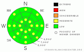
Danger Rose Tutorial
|
The avalanche danger is generally LOW. With day time heating, the danger will rise to MODERATE on both steep, sunny slopes and low elevation shady slopes, with human triggered wet loose avalanches possible. There are also isolated places where a person could trigger a wind drift or sensitive cornice along upper elevation ridgelines and in open bowls. |
|
|
CURRENT CONDITIONS |

|
Yet another day in paradise with sunny and warm weather, delightful, soft, settled powder on the sun and wind sheltered slopes and mostly stable avalanche conditions. And this time of year, less people are getting out, so there is much more untracked snow. Life is good. |
|
|
RECENT ACTIVITY |

|
We did not hear about any backcountry avalanche activity yesterday with the exception of some continued, shallow, wet sluffs at lower elevations and on steep, sun southerly facing slopes. A couple ski resorts were able to pry out a few, lingering wind slabs with explosives, but otherwise, everything is quite well-behaved. |
|
|
THREAT #1 |

|
| WHERE |
PROBABILITY |
SIZE |
TREND |
|
|
|
|
| |
|
|
Over the next
10 hours.
|
|
|
Once again, wet avalanche activity today will be determined by the balance between sun, wind and clouds. Temperatures remain on the cool side. It’s been freezing quite solid each night and the daytime highs are in the mid 30’s on the ridge tops. The winds have been light, but they have been strong enough to keep wet activity to a minimum. Today should be remarkably similar to yesterday. |
|
|
THREAT #2 |

|
| WHERE |
PROBABILITY |
SIZE |
TREND |
|
|
|
|
| |
|
|
Over the next
24 hours.
|
|
|
Although it keeps getting harder and harder to trigger some of the lingering wind slabs from the storm, you can still trigger one especially in steep, upper elevation terrain. As always, be suspicious of steep slopes with wind deposits, which will look smooth and rounded. Also, as usual, give cornices a wide berth because they tend to break back farther than you think. |
|
|
MOUNTAIN WEATHER |

|
Today should be very similar to yesterday with sunny skies, ridge top temperatures around 35, and 8,000’ temperatures in the lower 40’s. Ridge top winds will be light, around 5 mph but stronger on the highest peaks. Saturday should also be nice but we do have another weak shot of snow and wind starting Saturday night and Sunday. Then the rest of the week looks mild. |
|
|
GENERAL ANNOUNCEMENTS |
Our web site is now formatted for iPhone. You can also download a free iPhone application from Canyon Sports to display the Bottom Line. Search for Utah Avalanche on the Apple's iPhone Apps page or in iTunes.
If you want to get this avalanche advisory e-mailed to you daily click HERE.
For a text only version, the link is on the left side bar, near the top.
UDOT highway avalanche control work info can be found by calling (801) 975-4838. Our statewide toll free line is 1-888-999-4019 (early morning, option 8).
Donate to your favorite non-profit – The Friends of the Utah Avalanche Center. The UAC depends on contributions from users like you to support our work. To find out more about how you can support our efforts to continue providing the avalanche forecasting and education that you expect please visitour Friends page.
Your snow and avalanche observations can save someone’s life. Please let us know what you're seeing by leaving a message at (801) 524-5304 or 1-800-662-4140, or email us at uac@utahavalanchecenter.org. (Fax 801-524-6301).
The information in this advisory is from the U.S. Forest Service, which is solely responsible for its content. This advisory describes general avalanche conditions and local variations always occur.
Evelyn Lees will update this advisory by 7:30 tomorrow morning. |
|
|
This information does not apply to developed ski areas or highways where avalanche control is normally done. This advisory is from the U.S.D.A. Forest Service, which is solely responsible for its content. This advisory describes general avalanche conditions and local variations always occur. |
|
This advisory provided by the USDA Forest Service, in partnership with:
The Friends of the Utah Avalanche Center, Utah Division of State Parks and Recreation, Utah Division of Emergency Management, Salt Lake County, Salt Lake Unified Fire Authority and the friends of the La Sal Avalanche Center. See our Sponsors Page for a complete list. |
