Ogden Avalanche Advisory

Forecaster: Drew Hardesty

BOTTOM LINE

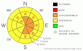
Danger by aspect and elevation on slopes approaching 35° or steeper.
(click HERE for tomorrow's danger rating)


Danger Rose Tutorial

Pockets of CONSIDERABLE exist in all wind drifted terrain, and most pronounced in upper elevation terrain with an easterly component. Human triggered avalanches are probable. Naturals are possible. Careful route finding and safe travel procedures are required. Out of the wind, the danger is MODERATE in the storm snow, and may still be more sensitive sitting on weak pre-existing snow in the sheltered north and easterly terrain.


CURRENT CONDITIONS

Mercy, Mercy. Storm totals look to be about 2’ in the Cottonwoods, 12-16” in the Ogden and Park City mountains, and 6-12” in Provo. Densities came in at 6-8% as the stellars and lightly rimed stellars stacked up in a hurry. Few stations have temps above zero, and the west-northwesterlies are still blowing pretty well – 20mph with gusts to 35. 11,000’ winds are blowing 40 gusting to 60.


RECENT ACTIVITY

A poor bond to the old snow surface and snowfall rates of, at times, 3-4”/hr led to widespread natural and human triggered avalanching in the new snow on all aspects along the mid and upper elevations. Sluffs and flowing debris often ran full track and packed quite a punch. At least one natural overran a just-set skin track – but that was the only untoward human-snow interaction we heard about.


THREAT #1

WHERE PROBABILITY SIZE TREND
      Over the next 24 hours.

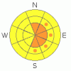
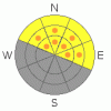
Wind slabs will be abundant and still-sensitive in any steep drifted terrain. I anticipate some continued danger in isolated high alpine terrain from the sustained winds and lingering instabilities from preserved light density snow, surface hoar, and faceted snow from last Friday. Slick crusts will allow snow to move fast and far.


THREAT #2

WHERE PROBABILITY SIZE TREND
      Over the next 24 hours.

It wouldn’t be outside the realm of possibility for the new snow and wind, with a little prodding, to collapse Sunday/Monday’s wind slabs onto the weaker snow below, releasing a much larger avalanche perhaps 2-3’ deep. I still found this interface to be sensitive yesterday. The wind slabs then proved highly sensitive – some were remotely triggered- and tripped up at least four who took rides on Sunday.


MOUNTAIN WEATHER

We’ll see overcast skies and some intermittent showers this morning as the storm moves off to the east. Strong sustained northwesterly winds will persist through much of the morning, but will be mostly confined to the upper elevations. Daytime highs will reach the single digits. We’ll have partly cloudy skies tonight and tomorrow. A weak storm passes by to the south Thursday with the models pointing toward a storm rolling through by late in the weekend.


GENERAL ANNOUNCEMENTS

The Avalanche Danger Scale is being revised for next winter. Our friends up in Canada have created a short survey found at the following link. Please help ensure the new Avalanche Danger Scale is effective by completing a survey. http://surveys.globalepanel.com/wix/p319164581.aspx

Wasatch Powderbird Guides didn’t get out on Sunday and most likely won’t get out today. Their operations planning page is here.

Our web site is now formatted for iPhone. You can also download a free iPhone application from Canyon Sports to display the Bottom Line. Search for Utah Avalanche on the Apple's iPhone Apps page or in iTunes.

Beacon training parks are up and running! There is one at Snowbasin, one on the Park City side at the top of Canyon’s gondola toward the Tombstone lift, one in Little Cottonwood near the Snowbird parking structure on the bypass road, and in Big Cottonwood a training park is at the west end of Solitude's lower parking lot.

If you want to get this avalanche advisory e-mailed to you daily click HERE.

For a text only version, the link is on the left side bar, near the top.

UDOT highway avalanche control work info can be found by calling (801) 975-4838. Our statewide toll free line is 1-888-999-4019 (early morning, option 8).

Donate to your favorite non-profit – The Friends of the Utah Avalanche Center. The UAC depends on contributions from users like you to support our work. To find out more about how you can support our efforts to continue providing the avalanche forecasting and education that you expect please visitour Friends page.

Your snow and avalanche observations can save someone’s life. Please let us know what you're seeing by leaving a message at (801) 524-5304 or 1-800-662-4140, or email us at uac@utahavalanchecenter.org. (Fax 801-524-6301).

I will update this advisory by 7:30 tomorrow morning.


This information does not apply to developed ski areas or highways where avalanche control is normally done.  This advisory is from the U.S.D.A. Forest Service, which is solely responsible for its content. This advisory describes general avalanche conditions and local variations always occur.


This advisory provided by the USDA Forest Service, in partnership with:

The Friends of the Utah Avalanche Center, Utah Division of State Parks and Recreation, Utah Division of Emergency Management, Salt Lake County, Salt Lake Unified Fire Authority and the friends of the La Sal Avalanche Center. See our Sponsors Page for a complete list.