Ogden Avalanche Advisory

Forecaster: Drew Hardesty

BOTTOM LINE

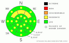
Danger by aspect and elevation on slopes approaching 35° or steeper.
(click HERE for tomorrow's danger rating)


Danger Rose Tutorial

The avalanche danger is mostly LOW this morning. Very isolated pockets of hard wind slab dot the upper elevation landscape, primarily on the northerly aspects. The wet avalanche potential will rise to MODERATE with daytime warming on all but the highest northerly facing aspects. Glide avalanches are likely to release through the next couple of days, even, perhaps, after the cold front.


CURRENT CONDITIONS

Skies are overcast again but the sun should break through in the next few hours. You’d never guess that the winds were still punishing: 30-40mph with gusts to 70. “Freezing temps” are down to 9000’. Now that half the west desert blankets the “snow”, it’s making it hard to wax. Anyone out there know if either Toko or Swix makes a ‘dust – isothermal snow – wind board’ hi-fluoro wax?

Dust on snow can play a significant role in the world of hydrology, if not the world of avalanches. Our own Tom Painter, skier, researcher, and professor at the U has made significant headway in the understanding of these impacts. Check out this NPR interview from a couple years ago.


RECENT ACTIVITY

Minor wet activity with some skier-initiated rollerballs and pinwheels.


THREAT #1

WHERE PROBABILITY SIZE TREND
      Over the next 12 hours.

Free water in the snowpack is not a good thing. It typically destroys the bonds between the snow grains, pools above an impermeable layer and you start to see wet slab avalanches. (Shouldn’t I be talking about this sort of thing in April?) The snowpack needs to develop good plumbing to quickly and efficiently move the free water vertically through the pack. We all see evidence of this once the spring snowpack has “matured” and we see creeks of water running down along the canyon roads.

The whole melt freeze cycle is a Dr. Jekyll (melt) and Mr. Hyde (freeze) diurnal cycle. You need both to develop a good “corn” snowpack for the spring. Without the thaw, you never develop larger grains; without the freeze, you get the continuous free water factory – and – with the presence of the impermeable layer or insulated persistent weakness, well, you know the rest.

I’d also start anticipating glide releases in the usual spots in Stairs Gulch, Mill B South, and Broads Fork of Big Cottonwood canyon. Avoid lagging in these runout zones there in the valley bottoms.


THREAT #2

WHERE PROBABILITY SIZE TREND
      Over the next 12 hours.

The dots up high reflect the isolated hard slabs......


MOUNTAIN WEATHER

Old school: look out the window to the west. Warm and windy yet again. 8000’ and 10,000’ temps will rise to the upper 40’s and the upper 30’s. Never fear: a cold front should crash through tonight, dropping temps back to the teens putting the brakes on the wind. 4-7” is expected through tomorrow for upper Big Cottonwood and the Ogden mountains - areas favored by a westerly flow. Another storm follows for Friday and again on Monday.


GENERAL ANNOUNCEMENTS

Our web page is now mobile-friendly for users of iPhone and iPod Touch.

Wasatch Powderbird Guides have been grounded due to weather. Their operations planning page is here.

Beacon training parks are up and running! There is one at Snowbasin, one on the Park City side at the top of Canyon’s gondola toward the Tombstone lift, one in Little Cottonwood near the Snowbird parking structure on the bypass road, and in Big Cottonwood a training park is at the west end of Solitude's lower parking lot.

If you want to get this avalanche advisory e-mailed to you daily click HERE.

For a text only version, the link is on the left side bar, near the top.

UDOT highway avalanche control work info can be found by calling (801) 975-4838. Our statewide toll free line is 1-888-999-4019 (early morning, option 8).

The UAC depends on contributions from users like you to support our work. To find out more about how you can support our efforts to continue providing the avalanche forecasting and education that you expect please visitour Friends page.

Your snow and avalanche observations can save someone’s life. Please let us know what you're seeing by leaving a message at (801) 524-5304 or 1-800-662-4140, or email us at uac@utahavalanchecenter.org. (Fax 801-524-6301).

The information in this advisory is from the U.S. Forest Service, which is solely responsible for its content. This advisory describes general avalanche conditions and local variations always occur.

Evelyn Lees will update this advisory by 7:30 tomorrow morning.


This information does not apply to developed ski areas or highways where avalanche control is normally done.  This advisory is from the U.S.D.A. Forest Service, which is solely responsible for its content. This advisory describes general avalanche conditions and local variations always occur.


This advisory provided by the USDA Forest Service, in partnership with:

The Friends of the Utah Avalanche Center, Utah Division of State Parks and Recreation, Utah Division of Emergency Management, Salt Lake County, Salt Lake Unified Fire Authority and the friends of the La Sal Avalanche Center. See our Sponsors Page for a complete list.