BOTTOM LINE
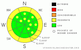
Danger by aspect and elevation on slopes approaching 35° or steeper.
(click HERE for tomorrow's danger rating)
|
Danger Rose Tutorial
|
The avalanche danger is MODERATE for wet loose sluffs, generally below about 7,000’, especially if it starts raining where you are. There is also a pockety MODERATE danger for a few old and new winds drifts, at mid and upper elevations. Isolated glide avalanches and large, sensitive ridgeline cornices round out the avalanche concerns to watch out for today. |
|
|
CURRENT CONDITIONS |

|
Under mostly cloudy skies, temperatures have finally dropped to well below freezing - into the teens and twenties. The only holdouts are a few of the lowest mountain stations in the Huntsville basin and Provo Area Mountains. The westerly winds have decreased, and are generally less than 15 mph, with only a few exposed peaks averaging in the 15 to 25 mph range. There is a scattering of soft powder on higher elevation, northerly facing slopes, sometimes with a whisper of a crust. Elsewhere, it’s supportable to mainly breakable crusts, many of which will not soften today. Luckily, the modern invention of grooming will let you fly down a smooth resort run, skate on a track or ride the miles of state snowmobile trails as you wait for tomorrow’s fresh powder. |
|
|
RECENT ACTIVITY |

|
There was no new avalanche activity reported from the backcountry yesterday. |
|
|
THREAT #1 |

|
| WHERE |
PROBABILITY |
SIZE |
TREND |

|
|
|
|
| |
|
|
Over the next
10 hours.
|
|
|
Cooling temperatures, clouds and winds should mostly put the kibosh on wet snow activity today. However, below about 7,000’ it still may be possible to trigger a wet sluff on a steep slope, especially if it starts to rain where you are. You may also find a few places where the cooling, frozen crusts are sitting on still wet snow, and steep slopes with this punchy structure should be avoided. |
|
|
THREAT #2 |

|
| WHERE |
PROBABILITY |
SIZE |
TREND |

|
|
|
|
| |
|
|
Over the next
24 hours.
|
|
|
Today’s increasing winds could create a few fresh drifts of snow at the mid to higher elevations, which should be avoided on steep slopes. In addition, there are reports of a few old hard drifts in open bowls and off ridgelines that could still be sensitive to the weight of a person. |
|
|
MOUNTAIN WEATHER |

|
An approaching cold front will bring increasing clouds and winds today, with a chance for an inch or two of snow by this afternoon. An initial rain/snow line of 6,500’ should lower to the valley floors by tonight. 5 to 10 inches of snow is possible by Friday afternoon, with the heaviest amounts north of I-80. The westerly winds will increase throughout the day, reaching the 20 to 30 mph range at the 10,000’ level, with gusts in the 40’s. The highest ridges will have gusts to near 60 mph. Temperatures will warm into the mid 30s at 8,000’ and low 20s at 10,000’, before dropping to near 10 Friday morning. Skies will rapidly clear Friday afternoon, with temperatures quickly warming on Saturday. A couple chances for snow are possible next week on a moist southwesterly flow. |
|
|
GENERAL ANNOUNCEMENTS |
Our web page is now mobile-friendly for users of iPhone and iPod Touch.
Wasatch Powderbird Guides operations planning page is here.
Beacon training parks are up and running! There is one at Snowbasin, one on the Park City side at the top of Canyon’s gondola toward the Tombstone lift, one in Little Cottonwood near the Snowbird parking structure on the bypass road, and in Big Cottonwood a training park is at the west end of Solitude's lower parking lot.
If you want to get this avalanche advisory e-mailed to you daily click HERE.
For a text only version, the link is on the left side bar, near the top.
UDOT highway avalanche control work info can be found by calling (801) 975-4838. Our statewide toll free line is 1-888-999-4019 (early morning, option 8).
The UAC depends on contributions from users like you to support our work. To find out more about how you can support our efforts to continue providing the avalanche forecasting and education that you expect please visitour Friends page.
Your snow and avalanche observations can save someone’s life. Please let us know what you're seeing by leaving a message at (801) 524-5304 or 1-800-662-4140, or email us at uac@utahavalanchecenter.org. (Fax 801-524-6301).
The information in this advisory is from the U.S. Forest Service, which is solely responsible for its content. This advisory describes general avalanche conditions and local variations always occur.
Bruce Tremper will update this advisory by 7:30 tomorrow morning. |
|
|
This information does not apply to developed ski areas or highways where avalanche control is normally done. This advisory is from the U.S.D.A. Forest Service, which is solely responsible for its content. This advisory describes general avalanche conditions and local variations always occur. |
|
This advisory provided by the USDA Forest Service, in partnership with:
The Friends of the Utah Avalanche Center, Utah Division of State Parks and Recreation, Utah Division of Emergency Management, Salt Lake County, Salt Lake Unified Fire Authority and the friends of the La Sal Avalanche Center. See our Sponsors Page for a complete list. |
