BOTTOM LINE
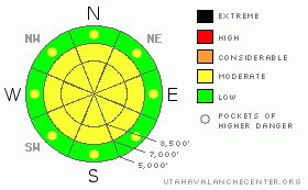
Danger by aspect and elevation on slopes approaching 35° or steeper.
(click HERE for tomorrow's danger rating)
|
Danger Rose Tutorial
|
The avalanche danger is MODERATE on slopes steeper than about 35 degrees for easily triggered sluffs and a few soft wind drifts along the higher ridges. Pockets of MODERATE avalanche danger exist on shady mid and low elevation slopes for triggering a slab avalanche up to 2 feet deep failing weak facets. This danger may be more widespread in the Ogden area mountains. Be alert for changes today - increasing winds or heating of the snow surface – could cause the avalanche danger to rapidly raise to CONSIDERABLE. |
|
|
CURRENT CONDITIONS |

|
Under bright moonlight, Ogden mountain temperatures have plunged into the single digits along the ridgelines, with mid mountain stations edging just above 10 degrees. The northwesterly winds have switched to the southwest, and remained light throughout the night, and are averaging less than 10 mph this morning, with the highest gusts not even 15 mph. So it’s another day in paradise, with the epitome of Utah powder - deep, light and plentiful. |
|
|
RECENT ACTIVITY |

|
Once again, there were many reports of easily triggered sluffs yesterday in steep terrain on a variety of aspects. In the steepest of terrain, some of these sluffs were deeper, taking out several days’ worth of snow, down to rock slabs. In addition, a slab avalanche was triggered on the north facing treed slope of Reynolds in Big Cottonwood Canyon. The second ski cut released a slide approximately 18" deep by 50 feet wide, and I’m suspecting surface hoar or near surface facets as the culprit weak layer. |
|
|
THREAT #1 |

|
| WHERE |
PROBABILITY |
SIZE |
TREND |

|
|
|
|
| |
|
|
Over the next
24 hours.
|
|
|
Dealing with the epic powder takes finesse and skill – the careful, careful use of slope cuts and sluff management will allow travel on the steeper slopes. But if you get on the wrong side of one of the larger sluffs, you’ll no longer be in the driver’s seat, but just along for the ride. The current sluffs can easily run several hundred feet, with enough punch to tumble, especially if pushed into unfriendly terrain such as a confined gully. Practice slope cuts on small test slopes, be looking over your shoulder, have a good spotter, and know your islands of safety. Even small terrain features such as tree wells and creek bottoms are dangerous.
Conditions could change in the blink of an eye today and you need to be your own forecaster. Watch out for any heating of the snow surface that could make it very sensitive – either from direct sun on steep slopes this morning or, as the high thin clouds move in, trapped heat warming the snow surface (“green housing”) on all aspects, including the shady slopes. And finally, the real wild card is the forecast increasing wind speeds. Even moderate, southerly winds will swiftly drift the light powder into sensitive drifts that will release under the weight of a person or naturally. |
|
|
THREAT #2 |

|
| WHERE |
PROBABILITY |
SIZE |
TREND |

|
|
|
|
| |
|
|
Over the next
24 hours.
|
|
|
Preserved buried surface hoar and near surface facets do exist below about 9,000’ throughout the Wasatch mountains, from Logan to Provo. While there are only isolated places where a slide 1 to 2 feet deep could be triggered on this weak layer today, slides can be triggered remotely from a distance or break out above you. With additional snow and the development of a denser slab, I expect this weak layer to become more dangerous over the weekend. |
|
|
MOUNTAIN WEATHER |

|
This morning’s clear skies will quickly fill with high thin clouds ahead of the next storm system. The southerly winds are forecast to increase this afternoon along the higher ridge lines into the 15 to 20 mph range, with gusts into the 30s. Temperatures will warm into the low 20s at 8,000’ and to near 10 at 10,000’. Snow, heavy at times, tonight through Saturday, could result in storm totals of a foot or more. After a break on Sunday, a stronger, windier system will impact northern Utah Monday through Tuesday. |
|
|
GENERAL ANNOUNCEMENTS |
Wasatch Powderbird Guides did not fly yesterday and today will have one ship in Cardiff, Days, Silver, Mineral, Grizzly, and another ship in White Pine and American Fork. Operations planning page is here.
Beacon training parks are up and running! There is one at Snowbasin, one on the Park City side at the top of Canyon’s gondola toward the Tombstone lift, one in Little Cottonwood near the Snowbird parking structure on the bypass road, and in Big Cottonwood a training park is at the west end of Solitude's lower parking lot.
If you want to get this avalanche advisory e-mailed to you daily click HERE.
For a text only version, the link is on the left side bar, near the top.
UDOT highway avalanche control work info can be found by calling (801) 975-4838. Our statewide toll free line is 1-888-999-4019 (early morning, option 8).
The UAC depends on contributions from users like you to support our work. To find out more about how you can support our efforts to continue providing the avalanche forecasting and education that you expect please visitour Friends page.
Your snow and avalanche observations help everyone in the backcountry community. Please let us know what you're seeing by leaving a message at (801) 524-5304 or 1-800-662-4140, or email us at uac@utahavalanchecenter.org. (Fax 801-524-6301).
The information in this advisory is from the U.S. Forest Service, which is solely responsible for its content. This advisory describes general avalanche conditions and local variations always occur.
Bruce will update this advisory by 7:30 tomorrow morning. |
|
|
This information does not apply to developed ski areas or highways where avalanche control is normally done. This advisory is from the U.S.D.A. Forest Service, which is solely responsible for its content. This advisory describes general avalanche conditions and local variations always occur. |
|
This advisory provided by the USDA Forest Service, in partnership with:
The Friends of the Utah Avalanche Center, Utah Division of State Parks and Recreation, Utah Division of Emergency Management, Salt Lake County, Salt Lake Unified Fire Authority and the friends of the La Sal Avalanche Center. See our Sponsors Page for a complete list. |
