BOTTOM LINE
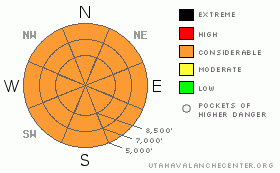
Danger by aspect and elevation on slopes approaching 35° or steeper.
(click HERE for tomorrow's danger rating)
|
Danger Rose Tutorial
|
Bottom Line for the Ogden area mountains:
The avalanche danger is CONSIDERABLE below about 8,500’ on all aspects for wet loose sluffs, possible gouging out to the ground at the lower elevations. Above about 8,500’ on slopes steeper than about 35 degrees, the avalanche danger is CONSIDERABLE due to expected increasing winds and additional snow. There is also the more isolated possibility of triggering a deeper slide breaking into weak layers near the ground, mostly on high elevation, shady slopes. |
|
|
CURRENT CONDITIONS |

|
The second in a series of warm, moist storms is bringing rain and snow to the Ogden area mountains. Like the last storm, the upper elevation snow densities of 10 to 15% will put a smile on the face of a Sierra skier like Kimbrough. Ogden mountians temperatures are in the low to mid 30's, with only the ridge lines dipping into the 20's. The southwesterly winds are averaging 15 to 20 mph, with gusts to 30. Below about 8,000’, the snowpack is wet slop, and in places you’ll sink to the ground. At the higher elevations, the dense snow is almost succeeding in covering the old tracks, and provides excellent creamy carving, riding and snowshoeing conditions. For a summary of snow and water totals from the last storm, go to the NWS public Information Statement HERE. |
|
|
RECENT ACTIVITY |

|
While many slopes were skied, boarded and snowmobiled uneventfully yesterday, there were at least 4 backcountry incidents. In the Granny Chute of Wolverine Cirque, the 3rd ski cut popped out 6 to 12 inch deep new snow slab about 200ft wide (10,600, N facing, not caught). In a steeper section of Hide-a-way Park (the ridge between Days and Silver) a triggered pocket turned into a large sluff, carrying a skier through trees, resulting in a partial burial and injured knee (9,400, N facing). Toledo Chute was human triggered 1/2 way down, with the sluff entraining snow and widening to full width (SE 10,000'). And finally, a pocket (approx 50ft wide by 1.5 ft deep) triggered in a shallow, rocky spot on north facing Kessler resulted in a short ride. |
|
|
THREAT #1 |

|
| WHERE |
PROBABILITY |
SIZE |
TREND |

|
|
|
|
| |
|
|
Over the next
24 hours.
|
|
|
Travel in steep terrain below about 8,000’ is not recommended. With additional rain today, more ice bonds in the already soaking snowpack will melt, and both human triggered and spontaneous wet, loose sluffs could occur on steep slopes, especially when it’s actually raining. Avoid travel in terrain traps such as gullies or below steep road banks, trail cuts, and steep roofs which will continue to release their snow. |
|
|
THREAT #2 |

|
| WHERE |
PROBABILITY |
SIZE |
TREND |

|
|
|
|
| |
|
|
Over the next
24 hours.
|
|
|
Yesterday’s new snow was sensitive only in scattered spots above about 9,000’, with a variety of culprit weak layers including slick crusts, lingering pockets of faceted snow, and slightly wind drifted snow. (Check out new snow profiles.) Today’s new snow may get reactive if the winds pick up as forecast, or later in the day if you’re in an area that receives 6 or more inches of new snow or during periods of high precipitation rates, when it starts snowing hard. |
|
|
THREAT #3 |

|
| WHERE |
PROBABILITY |
SIZE |
TREND |

|
|
|
|
| |
|
|
Over the next
24 hours.
|
|
|
Over the next few days, the dense snow gradually piling up will slowly overload the deeper weak layers near the ground. While more widespread problems may be a day or two away, it is possible to trigger a deeper slide in isolated places in shallow snowpack areas today. |
|
|
MOUNTAIN WEATHER |

|
Utah will remain under a moist, southwesterly flow through the weekend, with snowfall continuing into Monday. Today, expect 6 to 9” of dense new snow above about 9,000’, with rain below about 7,500’. The southwesterly winds are forecast to increase into the 10 to 20 mph range, with gusts into the 30’s. Temperatures will remain mild, in the upper 30’s at 8,000’ and the mid 20’s at 10,000’. Continued snow tonight through Monday could result in storm totals of 18 to 30 inches, with temperatures finally cooling into the teens on Monday. |
|
|
GENERAL ANNOUNCEMENTS |
WPG did not get out yesterday, and will not get out today. Operations planning page is here.
The last of the Brighton Discount tickets have been reduced to $45, with all proceeds going to the Friends of the Utah Avalanche Center. Click HERE for details.
The Friends of the Utah Avalanche Center is hosting a Level 2 avalanche class in February which is now open for registration by going to the Black Diamond retail store. More information is HERE.
Tickets are now available for the annual Backcountry Awareness Dinner on February 13th, with registration through the Snowbird Renaissance Center.
Beacon training parks are up and running! There is one at Snowbasin, one on the Park City side at the top of Canyon’s gondola, one in Little Cottonwood near the Snowbird parking structure on the bypass road, and in Big Cottonwood a training park is at the west end of Solitude's lower parking lot.
If you want to get this avalanche advisory e-mailed to you daily click HERE.
For a text only version, the link is on the left side bar, near the top.
UDOT highway avalanche control work info can be found by calling (801) 975-4838. Our statewide toll free line is 1-888-999-4019 (early morning, option 8).
The UAC depends on contributions from users like you to support our work. To find out more about how you can support our efforts to continue providing the avalanche forecasting and education that you expect please visit our Friends page.
Your snow and avalanche observations help everyone in the backcountry community. Please let us know what you're seeing by leaving a message at (801) 524-5304 or 1-800-662-4140, or email us at uac@utahavalanchecenter.org. (Fax 801-524-6301).
The information in this advisory is from the U.S. Forest Service, which is solely responsible for its content. This advisory describes general avalanche conditions and local variations always occur. This advisory does not apply to ski areas or highways where avalanche control is normally conducted.
Brett Kobernik will update this advisory by 7:30 tomorrow morning. |
|
|
This information does not apply to developed ski areas or highways where avalanche control is normally done. This advisory is from the U.S.D.A. Forest Service, which is solely responsible for its content. This advisory describes general avalanche conditions and local variations always occur. |
|
This advisory provided by the USDA Forest Service, in partnership with:
The Friends of the Utah Avalanche Center, Utah Division of State Parks and Recreation, Utah Division of Emergency Management, Salt Lake County, Salt Lake Unified Fire Authority and the friends of the La Sal Avalanche Center. See our Sponsors Page for a complete list. |
