BOTTOM LINE
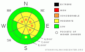
Danger by aspect and elevation on slopes approaching 35° or steeper.
(click HERE for tomorrow's danger rating)
|
Danger Rose Tutorial
|
Bottom Line for the Ogden area mountains:
The avalanche danger is MODERATE on slopes of about 35 degrees or steeper with recent soft wind drifts or old hard drifts hidden beneath the new snow. Pockets of CONSIDERABLE avalanche danger exist for deep slab avalanches on slopes facing generally north through east, above about 8,500 feet, especially those that have not slid since Christmas. |
|
|
CURRENT CONDITIONS |

|
Under partly cloudy skies, temperatures in the Ogden area mountians have dropped to near 10 along the higher ridgelines, and into the teens at the mid elevations. The westerly winds are breezy, in the 10 to 20 mph range. Thursday night’s uneven little storm dropped a solid foot of powder in the higher elevations of Big and Little Cottonwood, with 7 to 8 inches at the mid elevations and on the Park City side, and less than 6” in the Ogden and Provo area mountains. The old snow beneath is now generally supportable, and turning, riding and snowshoeing conditions are greatly improved to downright excellent in areas with the most new snow. |
|
|
RECENT ACTIVITY |

|
No new avalanche activity was reported form the Ogden area mountains yesterday. However, hard wind slabs were triggered with explosives in the Ogden area mountains as recently as Thursday. These were along heavily loaded ridge lines, and averaged 2 to 3 feet deep, 100 to 150' wide, failing on the light density snow beneath. In the SLC mountains the most recently reported human triggered deep slide was in Snake Creek 3 days ago on Wednesday. |
|
|
THREAT #1 |

|
| WHERE |
PROBABILITY |
SIZE |
TREND |

|
|
|
|
| |
|
|
Over the next
24 hours.
|
|
|
There are two rounds of wind drifts ready to trip you up. A few drifts may have formed from yesterday’s fresh powder will be easy to identify and mostly along the higher ridges. Experienced travelers will find careful slope cuts work well on the new soft wind drifts, but be prepared for them to run a bit faster and further than expected due to the hard bed surfaces beneath. Hidden beneath the fresh snow are the dense, old hard drifts from the mid week winds. Most of these have settled out, but there are few places on steep slopes where you may be able to trigger one for a deeper slide. Some cornices may be sensitive, breaking back further than expected. |
|
|
THREAT #2 |

|
| WHERE |
PROBABILITY |
SIZE |
TREND |

|
|
|
|
| |
|
|
Over the next
24 hours.
|
|
|
The more serious, but isolated, avalanche problem is the potential to trigger a deep slab avalanche on the facets near the ground. Most of the recent deep activity has been on steep northerly and easterly facing slopes above about 9,000’. You would most likely trigger one of these deep slides from a shallow, rocky spot, perhaps mid slope. If you’re digging any pits today, seek out these shallow spots, as they will be most representative of where you could trigger one of these slides. Also think about and try to avoid drainages and slopes with traditionally shallow snow packs. Photos and profile. |
|
|
MOUNTAIN WEATHER |

|
A northwest flow will reside across the region through the weekend. Clear skies this morning will give way to high and mid level clouds this afternoon and tonight. Temperatures today will warm to near 30 at 8,000’ and into the upper teens along the ridgelines. The pesky northwesterly winds will remain in the across the ridgelines, in the 15 to 25 mph range, with gusts into the 40’s at times. Thickening clouds Sunday and Monday may produce a few snow showers in the mountains. Then it’s high and dry, with a ridge dominating our weather to the extent I may be talking about a mini January corn cycle by next Saturday… |
|
|
GENERAL ANNOUNCEMENTS |
If you want to get this avalanche advisory e-mailed to you daily click
HERE.
For a text only version, the link is on the left side bar, near the top.
UDOT highway avalanche control work info can be found by calling (801) 975-4838. Our statewide toll free line is 1-888-999-4019 (early morning, option 8).
The UAC depends on contributions from users like you to support our work. To find out more about how you can support our efforts to continue providing the avalanche forecasting and education that you expect please visit our Friends page.
Your snow and avalanche observations help everyone in the backcountry community. Please let us know what you're seeing by leaving a message at (801) 524-5304 or 1-800-662-4140, or email us at uac@utahavalanchecenter.org. (Fax 801-524-6301).
The information in this advisory is from the U.S. Forest Service, which is solely responsible for its content. This advisory describes general avalanche conditions and local variations always occur. This advisory does not apply to ski areas or highways where avalanche control is normally conducted.
Brett Kobernik will update this advisory by 7:30 tomorrow morning. |
|
|
This information does not apply to developed ski areas or highways where avalanche control is normally done. This advisory is from the U.S.D.A. Forest Service, which is solely responsible for its content. This advisory describes general avalanche conditions and local variations always occur. |
|
This advisory provided by the USDA Forest Service, in partnership with:
The Friends of the Utah Avalanche Center, Utah Division of State Parks and Recreation, Utah Division of Emergency Management, Salt Lake County, Salt Lake Unified Fire Authority and the friends of the La Sal Avalanche Center. See our Sponsors Page for a complete list. |
