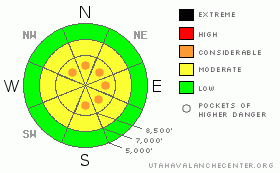
BOTTOM LINE
Danger by aspect and elevation on slopes approaching 35° or steeper.
(click HERE for tomorrow's danger rating)
|
Danger Rose Tutorial
|
The avalanche danger is generally MODERATE with pocket of CONSIDERABLE danger on any slope approaching 35 degrees or steeper with recent deposits of wind drifted snow and a CONSIDERABLE danger of deep slab avalanches on any slope facing generally north through east, above 8,500 feet that has not yet slid since Christmas. |
|
|
CURRENT CONDITIONS |

|
We got a welcome fresh coat of paint last night to spruce up the mountains for the weekend. Between 4 and 10 inches of 8-10 percent, new snow fell last night with the passing cold front and light snow showers are still falling in some areas. Snowbasin reported 4 inches of new snow. The pre-existing snow was exhausting, wind-damaged snow with dense, unsupportable, wind slabs that made for difficult trail breaking and poor riding conditions unless you were on a wide vehicle like a snowboard or snowmobile. The colder temperatures and new snow make things much more supportable. Ridge top winds are 15 mph from the northwest and temperatures have dropped to 15 degrees. |
|
|
RECENT ACTIVITY |

|
The dense, wind slabs seized up fairly quickly yesterday, making them stubborn to trigger. Nevertheless, some skiers kicking cornices in Rocky Point—a backcountry area near Alta triggered one wind slab about 2 feet deep and 50 feet wide. Avalanche control at one of the Little Cottonwood Canyon resorts continued to pull out a couple more, monster, deep slabs on east facing slopes and most resorts were able to trigger sizable wind slabs with explosives including along the upper ridge of Snowbasin. Not a lot of people were out yesterday in the backcountry because of the horrid, dense, slabby snow. |
|
|
THREAT #1 |

|
| WHERE |
PROBABILITY |
SIZE |
TREND |
|
|
|
|
| |
|
|
Over the next
24 hours.
|
|
|
Today you will likely find the usual round of fresh, wind slabs from the snow last night, mostly along the upper elevation ridges. I suspect most of the dense, wind slabs from the new snow and winds two days ago will be fairly well seized up, but you may be able to still trigger one of these, which will break out 2-3 feet deep. As usual, avoid any slope approaching 35 degrees or steeper with recent wind deposits. |
|
|
THREAT #2 |

|
| WHERE |
PROBABILITY |
SIZE |
TREND |
|
|
|
|
| |
|
|
Over the next
24 hours.
|
|
|
And yes, our old nemesis is STILL there—faceted snow buried 4-6 feet deep—difficult to trigger but if you do it will be gargantuan avalanche that will require extraordinary luck to survive—kind of like the snowboarders on Wednesday. This pesky problem continues to exist on slopes that have not slid yet, mostly on slopes north through east facing, above 8,500’. The weak layer is buried so deep that snowpit tests don’t work very well and they could easily break out on the 2, 10th or 100th person. Often you trigger it in a shallow area such as low on the slope, from a ridge or a steep, rocky slope. The smart folks are still avoiding these slopes unless they have good local knowledge of the history. Photos and profile. |
|
|
MOUNTAIN WEATHER |

|
Snow will continue this morning with a couple more inches added up until it clears out by this afternoon. Ridge top winds will blow 10-15 from the northwest with ridge top temperatures near 15 degrees and near 10 degrees tonight. We should have clear to partly cloudy skies through the weekend. The extended forecast calls says that this is the last significant snow for at least 10 days. We may get a couple weak shots early in the week but it will likely be mostly clouds. |
|
|
GENERAL ANNOUNCEMENTS |
If you want to get this avalanche advisory e-mailed to you daily click HERE.
For a text only version, the link is on the left side bar, near the top.
UDOT highway avalanche control work info can be found by calling (801) 975-4838. Our statewide toll free line is 1-888-999-4019 (early morning, option 8).
The UAC depends on contributions from users like you to support our work. To find out more about how you can support our efforts to continue providing the avalanche forecasting and education that you expect please visit our Friends page.
Your snow and avalanche observations help everyone in the backcountry community. Please let us know what you're seeing by leaving a message at (801) 524-5304 or 1-800-662-4140, or email us at uac@utahavalanchecenter.org. (Fax 801-524-6301).
The information in this advisory is from the U.S. Forest Service, which is solely responsible for its content. This advisory describes general avalanche conditions and local variations always occur. This advisory does not apply to ski areas or highways were avalanche control is normally conducted.
Evelyn Lees will update this advisory by 7:30 tomorrow morning. |
|
|
This information does not apply to developed ski areas or highways where avalanche control is normally done. This advisory is from the U.S.D.A. Forest Service, which is solely responsible for its content. This advisory describes general avalanche conditions and local variations always occur. |
|
This advisory provided by the USDA Forest Service, in partnership with:
The Friends of the Utah Avalanche Center, Utah Division of State Parks and Recreation, Utah Division of Emergency Management, Salt Lake County, Salt Lake Unified Fire Authority and the friends of the La Sal Avalanche Center. See our Sponsors Page for a complete list. |
