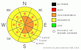
BOTTOM LINE
Danger by aspect and elevation on slopes approaching 35° or steeper.
(click HERE for tomorrow's danger rating)
|
Danger Rose Tutorial
|
Bottom Line for the Ogden area mountians:
The avalanche danger remains CONSIDERABLE on slopes steeper than about 35 degrees, above about 8,000’. Dense, new snow slabs and hard wind drifts 1 to 3 feet deep can be triggered. Ski cuts are useless on these hard slabs. Slopes facing northwest through northeast through southeast are particularly dangerous, as it is still possible for slides to release near the ground – these would be show stoppers, and perhaps life stoppers. In addition, there is a MODERATE danger for wet loose sluffs on all aspects below about 8,000’ and on all steep sunny slopes.
|
|
|
CURRENT CONDITIONS |

|
Under mostly clear skies, temperatures remained warm all night, and are currently in the mid 20’s along the Ogden ridge lines to low 30’s at 7,700’ locations. Yesterday’s nuking northwesterly winds finally relaxed a bit, and wind speeds are less than 15 mph this morning, with only the highest peaks still averaging 30 mph. Storm totals were 1 ½ to 3 feet in the Cottonwoods, and 12 to 20” in the Ogden, Provo and Park City mountains. All that is white is not powder – the combination of strong winds, inverted snow and warm temperatures provide challenging turning conditions, with the rare patch of soft snow to be found in very wind sheltered, shady terrain above about 8,500 feet.
|
|
|
RECENT ACTIVITY |

|
Reported avalanche activity in the Ogden area mountains includes natural avalanches Wednesday night in steep, mid and lower elevation terrain on north and easterly facing slopes, and a wet loose natural on a northerly facing slope at 4,600’. Yesterday, explosive control work released numerous class 2 and 3 slabs in upper elevation, north and east facing terrain, with crowns averaging 2’, and a maximum of 5’.
Today’s headliner is the very close call off of Peak 10321, which is on Pioneer Ridge. A snowboarder’s potentially deadly ride was stopped when his board got hung up in a small group of trees. Thanks to info and photos from Brandon Dodge, I was able to post a preliminary accident report on our photos page last night. Natural avalanche activity includes: Square Top, Reynolds, a large slide between Cardiac Ridge and High Ivory, two off of Gobblers, and one in lower Butler Fork. Some slides looked to be new snow only, some deeper, some repeaters.
Explosive control work triggered several large slides on southerly facing slopes above the highway in Little Cottonwood, including Little Superior running to the creek. A single 4 pounder released a very long running hard slab 4 to 5’ deep by 200’ wide on the facets near the ground, on northeasterly facing Pine Cone ridge. Widespread class 2 wind slabs were triggered with explosives at the resorts, up to 2 feet deep, in upper, mid and lower elevation terrain.
|
|
|
THREAT #1 |

|
| WHERE |
PROBABILITY |
SIZE |
TREND |
|
|
|
|
| |
|
|
Over the next
12 hours.
|
|
|
Today’s most widespread avalanche danger will be the dense wind drifts. Yesterday’s strong northwesterly winds drifted the snow at all elevations and cross loaded drifts on to all aspects, though slopes with an easterly component are the most heavily drifted. These drifts are hard slabs, the very tricky ones that fail on the second person or release above you once you’re well onto the slope. Cornices are also very sensitive and are breaking back further than expected.
|
|
|
THREAT #2 |

|
| WHERE |
PROBABILITY |
SIZE |
TREND |
|
|
|
|
| |
|
|
Over the next
12 hours.
|
|
|
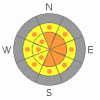
With the additional load of snow, the weak faceted snow near the ground remains active. Two very good indications yesterday of the potential for hard slab avalanches to release near the ground are the Peak 10321 human triggered slide and the easily triggered explosive slide on Pine Cone. Slopes that have slid previously this winter may release again. The problem remains concentrated on slopes facing northwest through southeast facing.
|
|
|
THREAT #3 |

|
| WHERE |
PROBABILITY |
SIZE |
TREND |

|
|
|
|
| |
|
|
Over the next
10 hours.
|
|
|
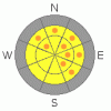
Wet snow loose sluffs will be possible again today with the warm temperatures and sun. As the day heats up and the snow gets wet and mushy, it will become easy to trigger these wet sluffs on steep slopes of all aspects at the mid and lower elevations. Especially avoid getting shoved into terrain traps such as gullies or below steep road banks, and watch out for slides off of steep roofs.
|
|
|
MOUNTAIN WEATHER |

|
Clouds, winds and temperatures will increase today ahead of the next cold, moist Pacific weather disturbance. Highs today will be near 40 at 8,000’ and in the low 30’s along the higher ridge lines. The winds are shifting to the southwest and will increase once again this afternoon into the 25 to 35 mph range across the higher terrain, with gusts into the 50’s. Mid elevation wind speeds will be around 15 mph, with gusts to 25. Frontal passage will be early this evening, with about a foot of snow expected my midday Friday as the storm tapers off.
|
|
|
GENERAL ANNOUNCEMENTS |
|
Wasatch Powderbird Guides did not get out yesterday due to weather, and today plan to be in the northern Powder Circuit and American Fork. For details, click here to go directly to their operations planning page.
Beacon training parks are up and running in the Cottonwoods – one is near the Snowbird parking structure on the bypass road in Little Cottonwood, and the other is at the west end of Solitude's lower parking lot in Big Cottonwood.
If you want to get this avalanche advisory e-mailed to you daily click HERE.
For a text only version, the link is on the left side bar, near the top.
UDOT highway avalanche control work info can be found by calling (801) 975-4838. Our statewide toll free line is 1-888-999-4019 (early morning, option 8).
The UAC depends on contributions from users like you to support our work. To find out more about how you can support our efforts to continue providing the avalanche forecasting and education that you expect please visit our Friends page.
Your snow and avalanche observations help everyone in the backcountry community. Please let us know what you're seeing by leaving a message at (801) 524-5304 or 1-800-662-4140, or email us at uac@utahavalanchecenter.org. (Fax 801-524-6301).
The information in this advisory is from the U.S. Forest Service, which is solely responsible for its content. This advisory describes general avalanche conditions and local variations always occur. This advisory does not apply to ski areas or highways were avalanche control is normally conducted.
Bruce Tremper will update this advisory by 7:30 tomorrow morning.
|
|
|
This information does not apply to developed ski areas or highways where avalanche control is normally done. This advisory is from the U.S.D.A. Forest Service, which is solely responsible for its content. This advisory describes general avalanche conditions and local variations always occur. |
|
This advisory provided by the USDA Forest Service, in partnership with:
The Friends of the Utah Avalanche Center, Utah Division of State Parks and Recreation, Utah Division of Emergency Management, Salt Lake County, Salt Lake Unified Fire Authority and the friends of the La Sal Avalanche Center. See our Sponsors Page for a complete list. |
