BOTTOM LINE
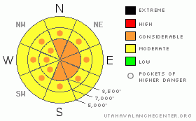
Danger by aspect and elevation on slopes approaching 35° or steeper.
(click HERE for tomorrow's danger rating)
|
Danger Rose Tutorial
|
A mostly Considerable exist in steep wind loaded terrain at the mid and upper elevations on slopes approaching 35 degrees and steeper. Any avalanche triggered on a northwest through northeast through southeast facing slope may step down to near the ground. Consequences of being caught are likely fatal. Wet activity harbors a MODERATE danger at the low elevations up to 7500' on all aspects.You may get impressive push a lanche debris piles into terrain traps today if you're not careful.
|
|
|
CURRENT CONDITIONS |

|
Looks like we're winding down from the powerhouse that effectively began on Monday. Overnight, the Cottonwoods and Park City mountains squeezed another 4-6” of very heavy snow out of the dregs of the storm, pushing storm totals to 32” in Little Cottonwood, and nearly 12-20” in the Ogden, Provo, and Park City mountains. With a rising temperature trend to make a coastie feel right at home, densities doubled in the last 12 or so hours: we now have 14% or more sitting on top of 5-8% of settled fluff. The rain/snow line bumped toward 7000' and observers this morning have reported some minor wet activity above the roads. The winds may be stealing the show. They've been blowing pretty good from the west and northwest since the beginning of the storm and this morning accelerated to 45-50mph with gusts to the mid-80's. Even the more protected areas are gusting into the 30's and 40's. Temps are in the low 20's at 10,000' and upper 20's at 8000'.
|
|
|
RECENT ACTIVITY |

|
UDOT avalanche control teams dumped up 4-8' deep piles of snow on the roads while ski patrol teams triggered numerous soft slabs up to 2' deep. Few ventured into the backcountry.
|
|
|
THREAT #1 |

|
| WHERE |
PROBABILITY |
SIZE |
TREND |
|
|
|
|
| |
|
|
Over the next
24 hours.
|
|
|
From the disastrous avalanche cycles in the northwest during the winter of 1909/1910, then District Weather Forecaster Edward Beals wrote
“It was not the quantity of snow alone which fell this year that caused so many avalanches, but it was the manner in which it fell, and many of the people most familiar with these phenomena knew a day or two before they occurred that slides were inevitable, and had they not sought places of safety more lives would have been lost than were under the existing conditions.”
We are seeing the same things now: it's not just how much has fallen, but how it has fallen, and what has accompanied it. Rising temperatures, strong winds, high snowfall rates, an arguably somewhat weak old snow surface. It all adds up. Lost in the overnight hours are the natural avalanches that have already occurred. The continued winds will no doubt initiate some more in the storm snow and artificial triggering (skiers/snowmachines/explosives) is also a certainty today on steep slopes, particularly in areas drifted by the winds.
|
|
|
THREAT #2 |

|
| WHERE |
PROBABILITY |
SIZE |
TREND |
|
|
|
|
| |
|
|
Over the next
24 hours.
|
|
|
Deep slab avalanches may also release with the added stress of a new snow avalanche in the usual terrrain (see danger rose).
|
|
|
THREAT #3 |

|
| WHERE |
PROBABILITY |
SIZE |
TREND |

|
|
|
|
| |
|
|
Over the next
24 hours.
|
|
|
Wet activity will also become a danger at the elevations under about 7500', particularly in heavily treed areas. Roof-a-lanches will also become a serious concern with the warming temperatures. Many steep roofs are likely to shed their new weight today, if they haven't already.
|
|
|
MOUNTAIN WEATHER |

|
We'll have mostly becoming partly cloudy skies today. The west to northwest winds are also expected to relax by the early afternoon and blow a more reasonable 30-35mph. Temps will continue their upward march to 25 at 10,00' and just below freezing at 8000'. We'll get a quick break tonight and tomorrow ahead of Thursday evening's storm, which may produce 7-10” for northwest flow favored areas.
|
|
|
GENERAL ANNOUNCEMENTS |
Wasatch Powderbird guides did not get out yesterday due to the weather. They're likely to remain grounded today. Click here to go directly to their operations planning page.
Beacon training parks are up and running in the Cottonwoods – one is near the Snowbird parking structure on the bypass road in Little Cottonwood, and the other is at the west end of Solitude's lower parking lot in Big Cottonwood.
If you want to get this avalanche advisory e-mailed to you daily click HERE.
For a text only version, the link is on the left side bar, near the top.
UDOT highway avalanche control work info can be found by calling (801) 975-4838. Our statewide toll free line is 1-888-999-4019 (early morning, option 8).
The UAC depends on contributions from users like you to support our work. To find out more about how you can support our efforts to continue providing the avalanche forecasting and education that you expect please visit our Friends page.
Your snow and avalanche observations help everyone in the backcountry community. Please let us know what you're seeing by leaving a message at (801) 524-5304 or 1-800-662-4140, or email us at uac@utahavalanchecenter.org. (Fax 801-524-6301).
The information in this advisory is from the U.S. Forest Service, which is solely responsible for its content. This advisory describes general avalanche conditions and local variations always occur.
Evelyn will update this advisory by 7:30 tomorrow morning. |
|
|
This information does not apply to developed ski areas or highways where avalanche control is normally done. This advisory is from the U.S.D.A. Forest Service, which is solely responsible for its content. This advisory describes general avalanche conditions and local variations always occur. |
|
This advisory provided by the USDA Forest Service, in partnership with:
The Friends of the Utah Avalanche Center, Utah Division of State Parks and Recreation, Utah Division of Emergency Management, Salt Lake County, Salt Lake Unified Fire Authority and the friends of the La Sal Avalanche Center. See our Sponsors Page for a complete list. |
