BOTTOM LINE
Danger by aspect and elevation on slopes approaching 35° or steeper.
(click HERE for tomorrow's danger rating)
|
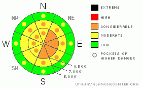
Danger Rose Tutorial
|
We have a CONSIDERABLE danger in areas that received more than a foot of snow and/or wind loaded in the last 24 hours. Human triggered avalanches, while still probable, are getting bigger and less manageable. Naturalling is likely as well in the new snow and may entrain quite a bit of the lower density snow from yesterday and Friday night. It is still possible to trigger a deep slab monster on the mid and upper elevation northwest through northeast through southeast facing slopes. Consequences are likely fatal. |
|
|
CURRENT CONDITIONS |

|
The Ogden mountains picked up 5" to 8”, and it's still snowing, albeit lightly. Densities shake out to a nice 5-7% but continues to be blown around by the stronger westerly winds. They blew 30-40mph for a few hours prior in the afternoon, paused, but seem to have picked back up in exposed terrain. Temps continue to march northward into the mid to upper teens. Riding conditions continue to be excellent, even in the lower angle terrain. |
|
|
RECENT ACTIVITY |

|
With a poor bond to Friday night's snow, it was not surprising that the combination of high snowfall rates and blowing winds produced quick and easy natural sluffing and shallow soft slabs to release on some of the steepest exposed terrain yesterday. After nearly three weeks of trickery in the snowpack, it was a change to finally have some 'manageable' avalanche issues; that is, snow that would predictably move at your skis or board and flush in the low density snow. The snowfall rates jumped again in the overnight hours and produced another round of shallow naturalling on many cutbanks above the roads in the canyons. The outlier was a deep slab natural reported off the north facing rocky chutes off Red Baldy in upper White Pine Canyon. With poor visibility, the crown depth was unknown, though it looked to have propagated 300' wide and ran down into the flats below to the other side of the subdrainage. This was likely prior to any of the heavier snowfall, and may have been triggered by the stronger winds at 11,000'. |
|
|
THREAT #1 |

|
| WHERE |
PROBABILITY |
SIZE |
TREND |
|
|
|
|
| |
|
|
Over the next
24 hours.
|
|
|
Should be very active again today with new snow activity up to a foot or more in exposed terrain. Ski and slope cuts will again be very effective with the storm snow and wind drifts. Test slopes and cornice drops will be good indicators for localized information. The drifting will be more pronounced on northeast through southeast facing slopes as well as on crossloaded breakovers. The newer snow is likely coming in more dense, creating an upside down layer cake on top of yesterday's champagne. |
|
|
THREAT #2 |

|
| WHERE |
PROBABILITY |
SIZE |
TREND |
|
|
|
|
| |
|
|
Over the next
24 hours.
|
|
|
Two deep releases in the past three days is a nagging reminder that a few bullets remain in the chamber. Many slopes have avalanched, but many remain. Which remain but have significant hangfire above? Which slid and have reloaded with intact weak layers? The 'bridge' above the weaknesses is 3-5' deep in most areas, with a slab 'hardness' of, typically, what we call pencil to nearly knife hard. Difficult to trigger? Yep. More likely in thinner, rocky areas and during times of added stress, like additional snow and wind, or rapid warming, like what we are expecting Wednesday night into Thursday. There's another name for a 'bridge'. It's called a slab. |
|
|
MOUNTAIN WEATHER |

|
We'll see an additional few inches today in areas favored by a northwest flow. Temps will rise to the upper teens at 10,000' and mid-twenties at 8000'. Winds will blow 25-35mph from the northwest along the high peaks, and about half that in more protected areas. Snowfall is likely through the day with enhanced snowfall this evening. A cold front is expected Friday for additional snow. |
|
|
GENERAL ANNOUNCEMENTS |
Wasatch Powderbird guides did not get out yesterday due to the weather. They're likely to remain grounded today. Click here to go directly to their operations planning page.
Beacon training parks are up and running in the Cottonwoods – one is near the Snowbird parking structure on the bypass road in Little Cottonwood, and the other is at the west end of Solitude's lower parking lot in Big Cottonwood.
If you want to get this avalanche advisory e-mailed to you daily click HERE.
For a text only version, the link is on the left side bar, near the top.
UDOT highway avalanche control work info can be found by calling (801) 975-4838. Our statewide toll free line is 1-888-999-4019 (early morning, option 8).
The UAC depends on contributions from users like you to support our work. To find out more about how you can support our efforts to continue providing the avalanche forecasting and education that you expect please visit our Friends page.
Your snow and avalanche observations help everyone in the backcountry community. Please let us know what you're seeing by leaving a message at (801) 524-5304 or 1-800-662-4140, or email us at uac@utahavalanchecenter.org. (Fax 801-524-6301).
The information in this advisory is from the U.S. Forest Service, which is solely responsible for its content. This advisory describes general avalanche conditions and local variations always occur.
I will update this advisory by 7:30 tomorrow morning. |
|
|
This information does not apply to developed ski areas or highways where avalanche control is normally done. This advisory is from the U.S.D.A. Forest Service, which is solely responsible for its content. This advisory describes general avalanche conditions and local variations always occur. |
|
This advisory provided by the USDA Forest Service, in partnership with:
The Friends of the Utah Avalanche Center, Utah Division of State Parks and Recreation, Utah Division of Emergency Management, Salt Lake County, Salt Lake Unified Fire Authority and the friends of the La Sal Avalanche Center. See our Sponsors Page for a complete list. |
