BOTTOM LINE
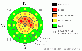
Danger by aspect and elevation on slopes approaching 35° or steeper.
(click HERE for tomorrow's danger rating)
|

Danger Rose Tutorial
|
Bottom Line for the Ogden area mountains:
There remains a CONSIDERABLE avalanche danger on any slope above 8,500 feet that faces northwest, north, northeast, and east steeper than about 35 degrees. Human triggered avalanche are probable on steep slopes that have not slid. Since the consequences of triggering on of these avalanche is so severe, I've included pockets of HIGH to represent the severity of the consequences. On these same aspects and elevations, slopes of about 30 to 35 degrees have a MODERATE danger as long as they are not adjacent to or below steeper slopes. With careful route finding, conservative decision making and good travel habits, terrain is available for riding and turning for those with training, experience and a cautious attitude. |
|
|
CURRENT CONDITIONS |

|
Happy New Year – and best wishes for a healthy and safe 2009. Under mostly clear skies, temperatures in the Ogden area mountains range from the upper teens along the ridges to the mid 30's at 6,400'. Across the exposed terrain, the average speeds of the westerly winds have been 30 to 35 mph, with gusts in the 40's. Mid elevation ridgelines are have wind speeds of 10 to 15 mph, with gusts to 30. There's fine recrystallized powder on sheltered shady slopes, with a mix of supportable wind board and breakable sun crusts common in the more exposed terrain and on the sunny slopes. |
|
|
RECENT ACTIVITY |

|
No new avalanche activity was reported from the backcountry yesterday, with most travelers carefully avoiding any steep terrain that has not slid. Explosive testing in unskied terrain in the Ogden mountains had minimal results. An excellent photo gallery with snowpack profiles from Ben Lomond can be found here. Resort explosive control work was only done on the Park City side, with results including several 3 foot deep 50' wide pockets down to the rain crust on shady slopes and a shallower 100' wide slide on a steep SE facing slope. |
|
|
THREAT #1 |

|
| WHERE |
PROBABILITY |
SIZE |
TREND |

|
|
|
|
| |
|
|
Over the next
24 hours.
|
|
|
The current complex pattern is a patchwork of several avalanche cycles, less widespread in the Ogden area mountains. Some slides ran above the infamous Thanksgiving rain crust, some slides to the ground, some of these slopes have blown in and reloaded with snow, and unfortunately, many slopes did not slide, and are still hanging in balance and waiting for a trigger. While the natural avalanche cycle certainly seems over, the more dangerous human triggered cycle is not over. While slides are getting harder to trigger on the persistent weak facets, they may not be any smaller – the potential for unpredictable, unsurvivable wide, deep slides still exists. Steep slopes that haven't slid are dangerous – the weakest spot on the slope may be well off the ridge line and tracks do not mean a slope is safe – slopes can fail on the second or even 4th person. Also, smaller deep slides can be triggered on steep treed slopes, where even a short ride can smash you up or bury you against a tree. Experienced travelers that are heading to slopes that have already slid need to realize that many are surrounded by questionable snow – access them carefully to be sure you are not in the runout from adjacent slopes or below substantial hang fire above.
Slope angle is the key to safe travel – stay off of and out from under slopes steeper than about 35 degrees. With careful travel on broad gentle ridges, peak bagging is fun, the sightseeing excellent, and turns on low angle slopes are fast in soft recrystallized powder. |
|
|
THREAT #2 |

|
| WHERE |
PROBABILITY |
SIZE |
TREND |

|
|
|
|
| |
|
|
Over the next
24 hours.
|
|
|
The brisk westerly winds are moving snow in upper elevation terrain, creating a few more fresh, cracky drifts along the high ridge lines, especially those facing northeast through southeast. Avoid travel on any slope with fresh wind drifts that could crack out beneath your feet. Also, with more sun and warmer temperatures, it will be possible to trigger damp sluffs on low and mid elevation slopes. |
|
|
MOUNTAIN WEATHER |

|
A weak warm front moving through the area today will bring increasing clouds with a chance for a few snow flurries. Mild temperatures will be in the mid 30's at 8,000' and mid to upper 20's at along the ridge lines. The westerly winds will remain breezy, with 15 to 25 mph averages across most ridges, and the highest terrain having gusts into the 40's. A fast moving Pacific storm system crossing the area Friday should freshen things up with 6 to 12” of new snow by Saturday morning, and drop temperatures back into the single digits. |
|
|
GENERAL ANNOUNCEMENTS |
Wasatch Powderbird guides are starting operations – click here to go directly to their operations planning page.
If you want to get this avalanche advisory e-mailed to you daily click HERE.
For the text-only advisory, click here.
UDOT highway avalanche control work info can be found by calling (801) 975-4838. Our statewide toll free line is 1-888-999-4019 (early morning, option 8).
The UAC depends on contributions from users like you to support our work. To find out more about how you can support our efforts to continue providing the avalanche forecasting and education that you expect please visit our Friends page.
If you’re getting out and see anything we should know about please let us know. You can leave a message at (801) 524-5304 or 1-800-662-4140, or email us at uac@utahavalanchecenter.org. (Fax 801-524-6301).
This advisory does not apply to ski areas or highways where avalanche control is normally done. The information in this advisory is from the U.S. Forest Service, which is solely responsible for its content. This advisory describes general avalanche conditions and local variations always occur.
Brett Kobernik will update this advisory by 7:30 tomorrow morning. |
|
|
This information does not apply to developed ski areas or highways where avalanche control is normally done. This advisory is from the U.S.D.A. Forest Service, which is solely responsible for its content. This advisory describes general avalanche conditions and local variations always occur. |
|
This advisory provided by the USDA Forest Service, in partnership with:
The Friends of the Utah Avalanche Center, Utah Division of State Parks and Recreation, Utah Division of Emergency Management, Salt Lake County, Salt Lake Unified Fire Authority and the friends of the La Sal Avalanche Center. See our Sponsors Page for a complete list. |


