AVALANCHE WARNING »
Dangerous avalanche conditions are occuring or are imminent.
Backcountry travel in avalanche terrain is not recommended.
|
 |
Notice:
THIS AVALANCHE WARNING IS FOR THE MOUNTAINS OF NORTHERN AND CENTRAL UTAH INCLUDING THE BEAR RIVER RANGE, WESTERN UINTAS, WASATCH, AND MANTI SKYLINE.
DANGEROUS AVALANCHE CONDITIONS WILL PERSIST THROUGHOUT THE WEEKEND. IT IS POSSIBLE FOR BACKCOUNTRY TRAVELERS TO TRIGGER VERY LARGE AND FAR RUNNING AVALANCHES ON SLOPES STEEPER THAN ABOUT 30 DEGREES AND REMOTELY FROM A DISTANCE. PEOPLE WITHOUT EXCELLENT AVALANCHE AND ROUTE FINDING SKILLS SHOULD AVOID BACKCOUNTRY TRAVEL. THIS WARNING DOES NOT INCLUDE SKI AREAS OR HIGHWAYS WHERE AVALANCHE CONTROL IS NORMALLY DONE.
|
|
|
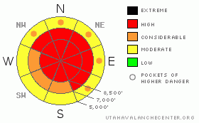
BOTTOM LINE
Danger by aspect and elevation on slopes approaching 35° or steeper.
(click HERE for tomorrow's danger rating)
|
Danger Rose Tutorial
|
Bottom Line for the Ogden area mountains:
The avalanche danger remains HIGH today, and human triggered avalanches are likely on many slopes of 30 degrees and steeper, in mid and upper elevation terrain of all aspects. Avalanches can be triggered from a distance - from below or from adjacent slopes to the side. Travel in avalanche terrain is not recommended.
|
|
|
CURRENT CONDITIONS |

|
Light snowfall overnight added another inch or two to the average storm totals of 1.5 to three feet of snow, with water equivalents generally in the 1.5 to 2.5” range. This morning, skies are clear to partly cloudy, and temperatures range from 10 above to 10 below. At most stations, the northwesterly winds are blowing in the 10 to 15 mph range, with gusts in the 20's. Across the higher peaks, it's a bit brisker, with averages 20 to 30 mph, and gusts in the 40's.
|
|
|
RECENT ACTIVITY |

|
A very happy ending occurred yesterday following a deep, full burial of a backcountry skier just north of Little Water Peak along the Big Cottonwood - Mill Creek divide. A slide broke out above the 3rd person as a party of 4 was breaking trail back up a 30 degree, northeast facing slope at about 8,900 feet. The slide was 4' deep by 100' wide and ran only 100', but pinned the person against a tree, beneath 6 feet of snow. A rapid beacon search by experienced partners, hard digging reached a blue and unresponsive friend. A few quick rescue breaths helped him come around and he was able to ski out. The rescuer regularly practices realistic, deep burials, which he credits for the fast recovery. An accident report has been posted.
We have no recent backcountry observations from the Ogden area mountains, but assume there could have been a natural avalanche cycle at high elevations, on northerly adn easterly facing slopes.
Even with bad visibility, naturals were observed in the Meadow Chutes (from Football field to El Rollo), Dutch Draw, the Big Cottonwood side of Twin Lakes Pass, on both the northerly and southerly facing sides of Little Cottonwood Canyon, and naturals 3 to 5 feet deep on the Park City side.
Explosive control work in the Cottonwood and Park City resorts, for American Fork Canyon and the Sundance road, and for the LCC highway were releasing numerous very large avalanches on aspects all the way around the compass, including the Flagstaff, Toledo, 10 Springs and Superior highway shots. Many of these slides were class 3 and 4 hard slabs, up to 8 feet deep, far running, with the crowns mid to low on slopes, or even pulling out well below the shot placements. Avalanches are running both above the rain/rime crust and to the ground.
|
|
|
THREAT #1 |

|
| WHERE |
PROBABILITY |
SIZE |
TREND |
|
|
|
|
| |
|
|
Over the next
24 hours.
|
|
|
We have a tricky snow pack. The culprit in the Ogden area mountains is the crust/facet combination near the ground. Some slides are running above the crust, not always removing these weak layers, so slide paths have filled back in and repeat. Some slides are running near the ground. The crust varies in thickness and weakness, so the pattern is tricky - some slopes are stable, while an adjacent slope could avalanche. So expect the unexpected: slides could pull out on lower angle slopes or mid elevation slopes, in pockets near trees, or be triggered by the second or third person. Slides are getting more stubborn and ski cuts worthless on these deep slabs.
Because of this, if you travel in the backcountry today, look at all terrain with fresh eyes – for example, the treed, mid elevation slopes we think of as “safe” may not be. Careful trip planning and constant reevaluation is a necessity. Take time to use a map, compass and inclinometer, and keep thinking about consequences of a slope should you be wrong and it slides, and use very conservative decision making anywhere facets are layered in the snowpack.
|
|
|
THREAT #2 |

|
| WHERE |
PROBABILITY |
SIZE |
TREND |
|
|
|
|
| |
|
|
Over the next
24 hours.
|
|
|
In addition, the strong, southwesterly Christmas Day winds created dense, hard wind drifts that are now hidden beneath light powder. It may feel like there's a great base, but the hidden, stubborn wind drifts can still be triggered on steep slopes. They'll be most widespread on northerly and easterly facing slopes, but were also deposited around terrain features such as slope breakovers, gully walls, and sub ridges.
|
|
|
MOUNTAIN WEATHER |

|
A moist, northwest flow will remain over the area through the middle of next week. Today, skies will be mostly cloudy, with scattered snow showers adding a trace to an inch of snow. Temperatures will remain cold – only reaching into the low teens at 8,000' and staying in the single digits at 10,000'. The northwesterly winds will be generally less than 10 mph, though the most exposed ridge lines and peaks will have averages of 20 to 30 mph, with gusts to 40. No significant storms are expected through the end of next week, though storms passing to the north may produce clouds and a few inches occasionally.
|
|
|
GENERAL ANNOUNCEMENTS |
|
Wasatch Powderbird guides are starting operations – click here to go directly to their operations planning page.
If you want to get this avalanche advisory e-mailed to you daily click HERE.
For the text-only advisory, click here.
UDOT highway avalanche control work info can be found by calling (801) 975-4838. Our statewide toll free line is 1-888-999-4019 (early morning, option 8).
The UAC depends on contributions from users like you to support our work. To find out more about how you can support our efforts to continue providing the avalanche forecasting and education that you expect please visit our Friends page.
If you’re getting out and see anything we should know about please let us know. You can leave a message at (801) 524-5304 or 1-800-662-4140, or email us at uac@utahavalanchecenter.org. (Fax 801-524-6301).
This advisory does not apply to ski areas or highways where avalanche control is normally done. The information in this advisory is from the U.S. Forest Service, which is solely responsible for its content. This advisory describes general avalanche conditions and local variations always occur.
Brett Kobernik will update this advisory by 7:30am tomorrow.
|
|
|
This information does not apply to developed ski areas or highways where avalanche control is normally done. This advisory is from the U.S.D.A. Forest Service, which is solely responsible for its content. This advisory describes general avalanche conditions and local variations always occur. |
|
This advisory provided by the USDA Forest Service, in partnership with:
The Friends of the Utah Avalanche Center, Utah Division of State Parks and Recreation, Utah Division of Emergency Management, Salt Lake County, Salt Lake Unified Fire Authority and the friends of the La Sal Avalanche Center. See our Sponsors Page for a complete list. |
