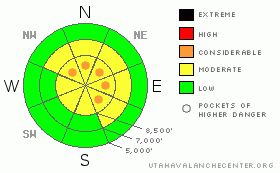
BOTTOM LINE
Danger by aspect and elevation on slopes approaching 35° or steeper.
(click HERE for tomorrow's danger rating)
|
Danger Rose Tutorial
|
Bottom Line for the Ogden area mountains:
The avalanche danger is generally MODERATE on steep mid and upper elevation slopes. Pockets of CONSIDERABLE danger exist on any steep slope with recent or new drifts of wind blown snow. You will find these slopes mostly along the upper elevation ridges on slopes that face north, northeast and east. There is also a concern that in isolated steep terrain, a slide could break into the weak November snow. |
|
|
CURRENT CONDITIONS |

|
Skies are overcast in the Ogden area mountains, and temperatures remain in the 10 to 15 degree range. The southwesterly winds are currently less than 10 mph, but yesterday and overnight ridgeline averages were 10 to 20, with gusts to 30. The snow has been piling up all week, and if you can get above about 8,000' there is excellent turning and riding conditions in wind sheltered terrain in deep, soft powder sitting on a mostly supportable base, even on low angle slopes. |
|
|
RECENT ACTIVITY |

|
There was one reported slide from the Ogden area mountains yesterday - a skier triggered soft slab on a steep, ESE facing slope at 7,600' in Hells Canyon. It was about 30 feet wide, and ran 200 vertical. More disturbingly, large collapses with both skier weight and explosives were reported from 3 different parties in the Ogden area mountains yesterday. Cracking was also observed in upper elevation, wind effected terrain.
The nightmarish avalanche cycle in the Salt Lake, Provo and Park City area mountains continues, and if you're heading south, check out the local forecasts. |
|
|
THREAT #1 |

|
| WHERE |
PROBABILITY |
SIZE |
TREND |

|
|
|
|
| |
|
|
Over the next
24 hours.
|
|
|
The Ogden area mountains seem to be inching up on dangerous conditions. Snow pits yesterday revealed the facets and crusts are weakening, as the deepening new snow increases the load. The large collapses heard in 3 drainages yesterday indicate the weak, faceted layers near the crust are getting close to their breaking point. With more wind and snow in the forecast, the avalanche conditions in the Ogden area mountains will get trickier and more dangerous Friday through the weekend. It will become possible for slides to break deeply onto the old, faceted snow layers. |
|
|
THREAT #2 |

|
| WHERE |
PROBABILITY |
SIZE |
TREND |
|
|
|
|
| |
|
|
Over the next
24 hours.
|
|
|
Increasing winds this afternoon will start to blow and drift the snow. Large quantities of light powder are available for transport, so sensitive drifts will rapidly form along ridges, and cross load around terrain features such as breakovers and subridges. Much of the new wind loading will be on north through easterly facing slopes, and any slide triggered in the sensitive new drifts could break into deeper layers. |
|
|
MOUNTAIN WEATHER |

|
A weather disturbance approaching from the south will bring light snow fall through early afternoon. 1 to 3” of snow is possible today in the Ogden area mountains. The winds will blow from the southwest to west, and increase this afternoon. This morning's ridge line speeds of 10 to 20 mph will increase to 20 to 30 mph this afternoon, with gusts in the 40's in exposed terrain. Temperatures will only warm into the mid teens. Strong, southwesterly winds will develop tonight and tomorrow morning ahead of a vigorous cold front which will cross the area Friday afternoon, bringing subzero temperatures and 6 to 12 inches of snow. |
|
|
GENERAL ANNOUNCEMENTS |
If you want to get this avalanche advisory e-mailed to you daily click HERE.
The Wasatch Powderbird Guides - for information, call them at 801-742-2800 or go to their daily blog.
UDOT highway avalanche control work info can be found by calling (801) 975-4838. Our statewide toll free line is 1-888-999-4019 (early morning, option 8).
The UAC depends on contributions from users like you to support our work. To find out more about how you can support our efforts to continue providing the avalanche forecasting and education that you expect please visit our Friends page.
If you’re getting out and see anything we should know about please let us know. You can leave a message at (801) 524-5304 or 1-800-662-4140, or email us at uac@utahavalanchecenter.org. (Fax 801-524-6301).
The information in this advisory is from the U.S. Forest Service, which is solely responsible for its content. This advisory describes general avalanche conditions and local variations always occur.
Bruce Tremper will update this forecast by 7:30 on Friday morning. |
|
|
This information does not apply to developed ski areas or highways where avalanche control is normally done. This advisory is from the U.S.D.A. Forest Service, which is solely responsible for its content. This advisory describes general avalanche conditions and local variations always occur. |
|
This advisory provided by the USDA Forest Service, in partnership with:
The Friends of the Utah Avalanche Center, Utah Division of State Parks and Recreation, Utah Division of Emergency Management, Salt Lake County, Salt Lake Unified Fire Authority and the friends of the La Sal Avalanche Center. See our Sponsors Page for a complete list. |
