25th Annual Black Diamond Fall Fundraising Party
Thursday, September 13; 6:00-10:00 PM; Black Diamond Parking Lot
25th Annual Black Diamond Fall Fundraising Party
Thursday, September 13; 6:00-10:00 PM; Black Diamond Parking Lot
| Advisory: Moab Area Mountains | Issued by Eric Trenbeath for Saturday - April 7, 2018 - 6:48am |
|---|

|
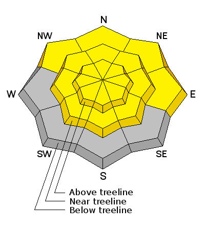
bottom line Strange weather is about to affect our snowpack. The overall impacts are uncertain, but rain on snow is never a good thing. The main event isn't expected until later this evening but expect a rising MODERATE danger for loose wet, avalanches on all aspects today. As the snowpack becomes saturated we may also see a MODERATE danger for large and destructive wet slab avalanches. The most suspect areas are on steep, rocky, northerly facing aspects right around treeline and below where loose, faceted snow still exists near the ground.
|
 |
special announcement This weekend will be the last of our regularly scheduled advisories. |
 |
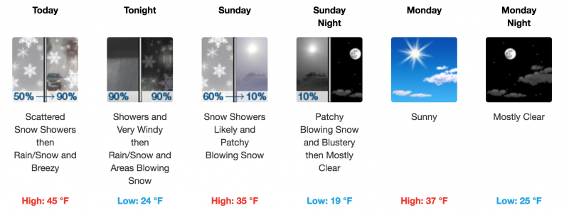
current conditions Skies are cloudy, NW winds are light, and 10,000' temps are in the low 30's. It's going to feel like the Paciifc Northwest up there today as warm and wet "atmospheric river" storm event moves into the region. Without a good re-freeze, snow conditions will be punchy this morning at mid and lower elevations. Upper elevation, northerly aspects are mostly wind hardened and slick. With warm temperatures and rain above 11,000' later in the day, expect the snow to become wet and sloppy by this afternoon. New snow totals in Gold Basin. Snow totals at the Geyser Pass Trailhead, (9600') Wind, temperature, and humidity on Pre Laurel Peak (11,700') |
 |
recent activity |
| type | aspect/elevation | characteristics |
|---|

|
|
LIKELIHOOD
 LIKELY
UNLIKELY
SIZE
 LARGE
SMALL
TREND
 INCREASING DANGER
SAME
DECREASING DANGER
|
|
description
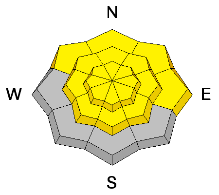
As temperaures warm and rain on snow intensifies, the danger will rise for loose wet avalanches on all aspects and elevations. Areas of steep and rocky terrain right around treeline are the most susceptible. The main rain event isn't supposed to arrive until late this afternoon or evening, but be alert throughout the day for increasing signs of wet instability. As the snow becomes sloppy and wet, or if you see, pinwheels, rollerballs, or especially loose snow sloughing, it's time to call it a day. |
| type | aspect/elevation | characteristics |
|---|

|
|
LIKELIHOOD
 LIKELY
UNLIKELY
SIZE
 LARGE
SMALL
TREND
INCREASING DANGER
SAME
DECREASING DANGER
|
|
description
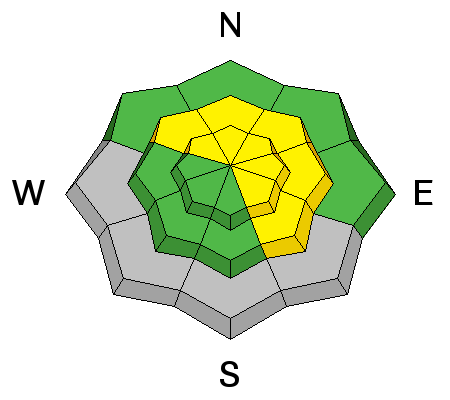
I'm not sure how the rain will affect buried weak layers in the snowpack but we could see some wet slabs breaking on facets near the ground. Wet slabs can be be large and destructive, and as the snow becomes saturated, avoid steep terrain where buried facets are suspected. Primary areas of concern are steep, rocky slopes right around treeline that face NW-E-SE. |
 |
weather A warm and moisture laden atmospheric river event is headed our way. Unfortunately it will be more prone to producing rain than snow up to as high as 11,000'. Most of the action starts this afternoon and we could see .5" - .75" of water by Sunday morning with just a few inches of snow.
|
| general announcements The UAC has new support programs with Outdoor Research and Darn Tough. Support the UAC through your daily shopping. When you shop at Smith's, or online at Outdoor Research, REI, Backcountry.com, Darn Tough, Patagonia, NRS, Stio, Amazon, and eBay a portion of your purchase will be donated to the FUAC. See our Donate Page for more details on how you can support the UAC when you shop. Benefit the Utah Avalanche Center when you buy or sell on eBay - set the Utah Avalanche Center as a favorite non-profit in your eBay account here and click on eBay gives when you buy or sell. You can choose to have your seller fees donated to the UAC, which doesn't cost you a penny. This information does not apply to developed ski areas or highways where avalanche control is normally done. This advisory is from the U.S.D.A. Forest Service, which is solely responsible for its content. This advisory describes general avalanche conditions and local variations always occur. |