25th Annual Black Diamond Fall Fundraising Party
Thursday, September 13; 6:00-10:00 PM; Black Diamond Parking Lot
25th Annual Black Diamond Fall Fundraising Party
Thursday, September 13; 6:00-10:00 PM; Black Diamond Parking Lot
| Advisory: Moab Area Mountains | Issued by Eric Trenbeath for Thursday - March 22, 2018 - 6:34am |
|---|


|
bottom line The avalanche danger is MODERATE across the board today and is expected to rise tomorrow with the approaching storm. -Right around tree line and above it is still possible to trigger a wind slab or deeper persistent slab avalanche up to 4' deep on slopes that face NW-N-E. Avoid steep wind drifted slopes, blind convexities, and areas of rocky or more radical terrain. Steep wooded areas are also suspect. -With warm temperatures, the lack of a solid overnight refreeze, and the threat of rain on snow, there is also the danger for loose wet avalanches. Signs of instability include roller balls, pinwheels, and sloppy wet snow. Get off of and out from under steep slopes when these signs are present. Expect a rising avalanche danger over the next 24 hours.
|
 |
special announcement Episode 7 of the UAC Podcast "Mastery and False Mastery - An Interview with 'Big' Don Sharaf" is live. With a snow career spanning over 30 years, Don has enough mileage in the mountains to have learned a thing or two, including the profound value of humility when staring into the face of the dragon. Listen in on our conversation about the idea of mastery and if such a thing can exist in the avalanche world. Check it out on the UAC blog, ITunes, Stitcher, or wherever you get your podcasts. The UAC Marketplace is still open. Our online marketplace still has deals on skis, packs, airbag packs, beacons, snowshoes, soft goods and much more. INSTAGRAM! We now have a UAC-Moab Instagram page. You can find it here....but better yet follow us on your smartphone. Confused? Ask a teenager. |
 |
current conditions Clouds are moving in over the area, southerly winds are averging 25 mph with gusts to 40, and it's a very warm 39 degrees at the Geyser Pass Trailhead. Sunday's 16" of low density snow has quickly receded into history and most surfaces are now showing the affects of wind, sun, and warm temperatures. Base depth in Gold Basin: 41" Base depth at Geyser Pass Trailhead: 29" New snow totals in Gold Basin. Snow totals at the Geyser Pass Trailhead, (9600') Wind, temperature, and humidity on Pre Laurel Peak (11,700') Road conditions to Geyser Pass Trailhead: Grand County plowed the road on Tuesday. Expect to find it snowpacked and slicked with mud on the lower end. Grooming conditions: Trails are not groomed. |
 |
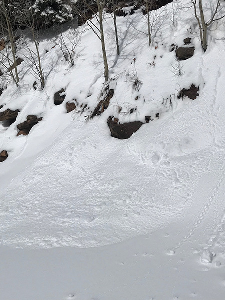
recent activity Most of the avalanche activity during Sunday's storm was confined to the new snow running as loose snow sloughs, storm slabs or wind slabs, but there appears to have been a few pockets in steep, rocky terrain that pulled out into older snow.
This avalanche appears to have broken into old snow and looks to be up to 3' deep. Note the character of the surrounding terrain - rocky, featured, and right near treeline, a typical area for finding underlying weak snow. (Tim Mathews photo) |
| type | aspect/elevation | characteristics |
|---|

|

|
LIKELIHOOD
 LIKELY
UNLIKELY
SIZE
 LARGE
SMALL
TREND
 INCREASING DANGER
SAME
DECREASING DANGER
|
|
description
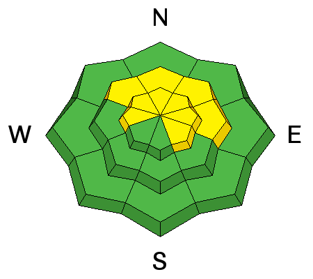
Time and warm temperatures have worked to strengthen exisiting wind slabs, but drifted snow is scattered liberally across exposed terrain. Crossloading has also been a factor and slabs have formed along the lee sides of gully walls and terrain features. Slopes with a smooth, rounded, fat appearance remain suspect even if other signs of instability such as cracking in the snow surface aren't present. A triggered wind slab also has the potential to step down into a buried weak layer causing a deeper and more dangerous persistent slab avalanche. Choose slopes wisely and avoid steep convexiiteis and blind break overs. Expect the danger for wind slabs to rise tonight as new snow begins to accumulate. A few of the ridges are starting to develop large cornices. Give cornices a wide berth when you are traveling on ridge crests where they are present and be aware of what's above you. |
| type | aspect/elevation | characteristics |
|---|

|
|
LIKELIHOOD
LIKELY
UNLIKELY
SIZE
 LARGE
SMALL
TREND
INCREASING DANGER
SAME
DECREASING DANGER
|
|
description
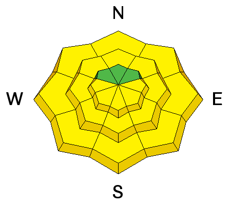
The persistent slab problem is tricky. Some areas have relatively strong snow and other areas still have very weak and reactive snow. The weakest areas are in steep, rocky, and wooded terrain right around tree line and above where the base of the snowpack is plagued by loose, sugary, faceted snow. Slopes with an easterly component are the most suspect. The snowpack may be stronger on more open slopes and bowls The only way to know for sure is to dig down and perform a stability test. Also keep in mind that thinner areas along slope margins and near rock outcroppings can provide trigger points and avalanches up to 4' deep remain possible. The incoming storm will add further stress to the snowpack and areas with the weakest snow will be affected. The video below illustrates the problem. |
| type | aspect/elevation | characteristics |
|---|

|
|
LIKELIHOOD
 LIKELY
UNLIKELY
SIZE
LARGE
SMALL
TREND
INCREASING DANGER
SAME
DECREASING DANGER
|
|
description
Warm temperatures, the lack of an overnight refreeze, and the threat of rain on snow all spell potential loose, wet slide activity. Move off of steep slopes as they start to become damp, or especially if they become wet and sloppy. Signs of instability include roller balls, pinwheels, or actual loose snow sloughing.
Even small slides such as this are an indicator of wet snow instability. (Tim Mathews photo) |
 |
weather A warm, wet, and windy "atmospheric river" is moving into our area later today bringing rain and snow tonight and snow tomorrow. The system is complex and unpredictable but it looks like we could see between .5" and .75" of water with 6-10" of snow. Today look for increasing southerly winds in the 25-35 mph range and very warm temperatures. High's at 10,000' will be in the low 40's.
|
| general announcements The UAC has new support programs with Outdoor Research and Darn Tough. Support the UAC through your daily shopping. When you shop at Smith's, or online at Outdoor Research, REI, Backcountry.com, Darn Tough, Patagonia, NRS, Stio, Amazon, and eBay a portion of your purchase will be donated to the FUAC. See our Donate Page for more details on how you can support the UAC when you shop. Benefit the Utah Avalanche Center when you buy or sell on eBay - set the Utah Avalanche Center as a favorite non-profit in your eBay account here and click on eBay gives when you buy or sell. You can choose to have your seller fees donated to the UAC, which doesn't cost you a penny. This information does not apply to developed ski areas or highways where avalanche control is normally done. This advisory is from the U.S.D.A. Forest Service, which is solely responsible for its content. This advisory describes general avalanche conditions and local variations always occur. |