25th Annual Black Diamond Fall Fundraising Party
Thursday, September 13; 6:00-10:00 PM; Black Diamond Parking Lot
25th Annual Black Diamond Fall Fundraising Party
Thursday, September 13; 6:00-10:00 PM; Black Diamond Parking Lot
| Advisory: Moab Area Mountains | Issued by Eric Trenbeath for Monday - March 19, 2018 - 6:25am |
|---|


|
bottom line The avalanche danger is CONSIDERABLE and dangerous avalanche conditions exist, particularly in upper elevation, wind exposed terrain that faces NW-N-E. Human triggered wind slab avalanches, and deeper persistent slab avalanches up to 4' deep are likely in these areas. Backcountry travelers need to possess good snow stability assessment and route finding skills. There is a MODERATE danger for storm snow avalanches on terrain steeper than 35 degrees on all aspects and elevations. This refers to loose snow sluffing and soft cohesive slab releases in the most recent snow. As the strong sun affects the new snow, we may begin to see some loose wet, sluffing. Signs of instability include rollerballs, pinwheels, and sloppy wet snow. Get off of and out from under steep slopes if these signs are present.
|
 |
special announcement Grand County will not be plowing today so you will be on your own. Deep and drifted snow is on the road and 16" is in the parking lot. I drove down yesterday afternoon following another vehicle so at least a two track exists. Episode 7 of the UAC Podcast "Mastery and False Mastery - An Interview with 'Big' Don Sharaf" is live. With a snow career spanning over 30 years, Don has enough mileage in the mountains to have learned a thing or two, including the profound value of humility when staring into the face of the dragon. Listen in on our conversation about the idea of mastery and if such a thing can exist in the avalanche world. Check it out on the UAC blog, ITunes, Stitcher, or wherever you get your podcasts. The UAC Marketplace is still open. Our online marketplace still has deals on skis, packs, airbag packs, beacons, snowshoes, soft goods and much more. INSTAGRAM! We now have a UAC-Moab Instagram page. You can find it here....but better yet follow us on your smartphone. Confused? Ask a teenager. |
 |
current conditions Wow, that was quite a storm! 16" of low density snow stacked up in a 12 hour period yesterday providing by far the best powder conditions of the year. With clear skies today, conditions in the mountains will be sublime. Southerly winds during the storm were pretty well behaved averaging 15 mph with occasional gusts to 30 along upper elevation ridge crests. Shifting to northwesterly by late afternoon, winds made a slight bump up into the 25-30 mph range as the storm exited the area. They quickly dropped of and have been light since before midnight. 10,000' temps this morning are in the single digits. Base depth in Gold Basin: 51" Base depth at Geyser Pass Trailhead: 37" New snow totals in Gold Basin. Snow totals at the Geyser Pass Trailhead, (9600') Wind, temperature, and humidity on Pre Laurel Peak (11,700') Road conditions to Geyser Pass Trailhead: Grand County will not be plowing today so you will be on your own. Deep and drifted snow is on the road and 16" is in the parking lot. I drove down yesterday afternoon following another vehicle so at least a two track exists. Grooming conditions: Trails are not groomed and are covered in deep snow. |
 |
recent activity |
| type | aspect/elevation | characteristics |
|---|

|
|
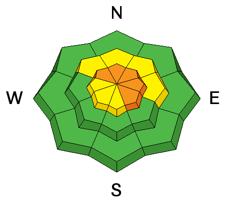
LIKELIHOOD
 LIKELY
UNLIKELY
SIZE
 LARGE
SMALL
TREND
 INCREASING DANGER
SAME
DECREASING DANGER
|
|
description
Winds were not out of hand yesterday, but with 16" of low density lying around, it doesn't take much to move it. Yesterday I observed numerous areas of wind drifted snow up to 2' deep or more, mainly along upper elevation ridge crests. Avoid slopes steeper than 35 degrees that have a smooth rounded appearance and look for signs of growing instability such as cracking in the snow surface. A triggered wind slab today may also have the potential to step down into a buried weak layer causing a deeper and more dangerous persistent slab avalanche. A few of the ridges are starting to develop large cornices and today's winds will create new, sensitive additions. Give cornices a wide berth when you are traveling on ridge crests where they are present and be aware of what's above you. |
| type | aspect/elevation | characteristics |
|---|

|
|
LIKELIHOOD
LIKELY
UNLIKELY
SIZE
 LARGE
SMALL
TREND
INCREASING DANGER
SAME
DECREASING DANGER
|
|
description
The recent snow has provided enough of a load to stress buried weak layers in the snowpack, particularly in areas of steep, rocky, or wooded terrain right around tree line and above where the base of the snowpack is plagued by loose, sugary, faceted snow. Slopes with an easterly component are the most suspect and human triggered avalanches up to 4' deep are likely in many areas. Spatial variability is key - more open slopes and bowls may have a stronger snowpack but thinner areas along slope margins and near rock outcroppings can provide trigger points. Until the snowpack has time to adjust to the new load, steep slopes facing NW-N-E should be avoided. |
| type | aspect/elevation | characteristics |
|---|

|

|
LIKELIHOOD
 LIKELY
UNLIKELY
SIZE
LARGE
SMALL
TREND
INCREASING DANGER
SAME
DECREASING DANGER
|
|
description
Storm snow instabilities should stabilize today, but that was a lot of snow in a short amount of time. Today it will still be possible to trigger loose snow sluffs or soft cohesive slabs within the new snow on steep terrain, on all aspects. You can usually check for instabilities with a slope cut. And finally, daytime temps are going to remain cool but the sun is high in the sky and we could see some loose wet sluffing in the new snow later in the day. Look for signs of instability such as rollerballs, pinwheels, and sloppy wet snow. Get off of and out from under steep slopes if these signs are present. |
 |
weather A gorgeous day is on tap with sunny skies, light NW winds and 10,000' highs in the mid 20's. Next chance for a storm is Thursday. |
| general announcements The UAC has new support programs with Outdoor Research and Darn Tough. Support the UAC through your daily shopping. When you shop at Smith's, or online at Outdoor Research, REI, Backcountry.com, Darn Tough, Patagonia, NRS, Stio, Amazon, and eBay a portion of your purchase will be donated to the FUAC. See our Donate Page for more details on how you can support the UAC when you shop. Benefit the Utah Avalanche Center when you buy or sell on eBay - set the Utah Avalanche Center as a favorite non-profit in your eBay account here and click on eBay gives when you buy or sell. You can choose to have your seller fees donated to the UAC, which doesn't cost you a penny. This information does not apply to developed ski areas or highways where avalanche control is normally done. This advisory is from the U.S.D.A. Forest Service, which is solely responsible for its content. This advisory describes general avalanche conditions and local variations always occur. |