25th Annual Black Diamond Fall Fundraising Party
Thursday, September 13; 6:00-10:00 PM; Black Diamond Parking Lot
25th Annual Black Diamond Fall Fundraising Party
Thursday, September 13; 6:00-10:00 PM; Black Diamond Parking Lot
| Advisory: Moab Area Mountains | Issued by Eric Trenbeath for Monday - March 5, 2018 - 6:03am |
|---|


|
bottom line The avalanche danger is MODERATE on steep slopes, primarily above treeline that have recent deposits of wind drifted snow. Areas of MODERATE danger also exist for human triggered avalanches 1- 3' deep. These will be most pronounced at and above treeline on steep northwest to north to southeasterly facing slopes. Elsewhere the avalanche danger is generally LOW.
|
 |
special announcement Grand County will be plowing the road this morning. Expect to find the road closed between 9:00 and noon. Thanks to Drew Hardesty for coming down and making the exchange possible. It was a great experience for me to be up in the Wasatch, admitedly where there is some more snow. But I look forward to returning to our desert range. Episode 6 of the UAC podcast "A Conversation with Tom Kimbrough" is live. We explore ideas about lifetime exposure to risk and what role Buddhism has played in his life as a climber, skier, and soon-to-be octogenarian. We talk about what has changed over the years in snow science and the role of mentorship in the world of avalanche forecasting and other professions and pursuits. Check it out on ITunes, Stitcher, the UAC blog. The UAC Marketplace is still open. Our online marketplace still has deals on skis, packs, airbag packs, beacons, snowshoes, soft goods and much more. INSTAGRAM! We now have a UAC-Moab Instagram page. You can find it here....but better yet follow us on your smartphone. Confused? Ask a teenager.
|
 |
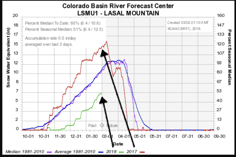
current conditions The La Sals picked up about 6" from yesterday's storm. Not as much as we need, but at this point we'll take what we get. Strong southerly winds blew throughout the day yesterday and they shifted to northwesterly last night averaging 20-30 mph along ridgetops. Much of the exposed terrain above treeline has taken quite a hit from the wind and sun, and best bet for taking advantage of the new snow will be in sheltered areas. Drew and Zinnia were out and about last week and left these observations. Base depth in Gold Basin: 40" Base depth at Geyser Pass Trailhead: 28" New snow totals in Gold Basin. Snow totals at the Geyser Pass Trailhead, (9600') Wind, temperature, and humidity on Pre Laurel Peak (11,700') Road conditions to Geyser Pass Trailhead: The road is snowpacked and icy in places. Good tires and at least front-wheel drive recommended. Grooming conditions: Grand County will be plowing this morning. A look at this season compared to last year..and the average. The below graph is from the NRCS La Sals Snotel site at roughly 9570'. We are currently 60% of average - and - well off of last year's banner snowpack season. Pray for snow.
|
| type | aspect/elevation | characteristics |
|---|

|

|
LIKELIHOOD
 LIKELY
UNLIKELY
SIZE
 LARGE
SMALL
TREND
 INCREASING DANGER
SAME
DECREASING DANGER
|
|
description
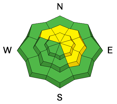
The new snow and wind loading has added additional stress to the pervasive persistent slab problem. Though isolated, this problem presents the greatest threat to backcountry travelers where avalanches up to 3' deep are possible. Suspect steep slopes and areas with rocky, extreme terrain that faces primarily NW-N-E though there may be outlying problem areas that face west or southeast. |
| type | aspect/elevation | characteristics |
|---|

|
|
LIKELIHOOD
LIKELY
UNLIKELY
SIZE
 LARGE
SMALL
TREND
INCREASING DANGER
SAME
DECREASING DANGER
|
|
description
Recent shallow deposits of wind drifted snow exist on the lee sides of ridge crests and terrain features in upper elevation, wind exposed terrain. Additionally, hard wind slabs are prevalent on many aspects and elevations and will remain stubborn (but not impossible) for human triggering. They tend to break well above you on the slope, especially as you near the tapered portion of the teardrop where the slab becomes much thinner. Listen for hollow sounds and collapsing...but these may not be present at all. Lastly, avoid being on or beneath heavily corniced ridgelines as they may fail on approach or without warning.
|
 |
weather
|
| general announcements The UAC has new support programs with Outdoor Research and Darn Tough. Support the UAC through your daily shopping. When you shop at Smith's, or online at Outdoor Research, REI, Backcountry.com, Darn Tough, Patagonia, NRS, Stio, Amazon, and eBay a portion of your purchase will be donated to the FUAC. See our Donate Page for more details on how you can support the UAC when you shop. Benefit the Utah Avalanche Center when you buy or sell on eBay - set the Utah Avalanche Center as a favorite non-profit in your eBay account here and click on eBay gives when you buy or sell. You can choose to have your seller fees donated to the UAC, which doesn't cost you a penny. This information does not apply to developed ski areas or highways where avalanche control is normally done. This advisory is from the U.S.D.A. Forest Service, which is solely responsible for its content. This advisory describes general avalanche conditions and local variations always occur. |