25th Annual Black Diamond Fall Fundraising Party
Thursday, September 13; 6:00-10:00 PM; Black Diamond Parking Lot
25th Annual Black Diamond Fall Fundraising Party
Thursday, September 13; 6:00-10:00 PM; Black Diamond Parking Lot
| Advisory: Moab Area Mountains | Issued by Eric Trenbeath for Sunday - February 25, 2018 - 6:53am |
|---|


|
bottom line Though trending downward, the avalanche danger remains CONSIDERABLE today on steep slopes that face NW-N-E right around treeline and above, especially on slopes that have recent deposits of wind drifted snow. Human triggered avalanches up to 3' deep are likely in these areas and backcountry travelers should continue to make conservative decisions. The avalanche danger is MODERATE below treeline. Most south facing terrain offers LOW danger.
|
 |
special announcement Episode 5 of the UAC podcast "To Hell in a Heartbeat - A Conversation With Tom Diegel and Matt Clevenger About the 12.26.08 Full Burial on Little Water" is live. Matt and Tom talk about the avalanche documented in To Hell in a Heartbeat. Check it out on ITunes, Stitcher, the UAC blog. The UAC Marketplace is still open. Our online marketplace still has deals on skis, packs, airbag packs, beacons, snowshoes, soft goods and much more. |
 |
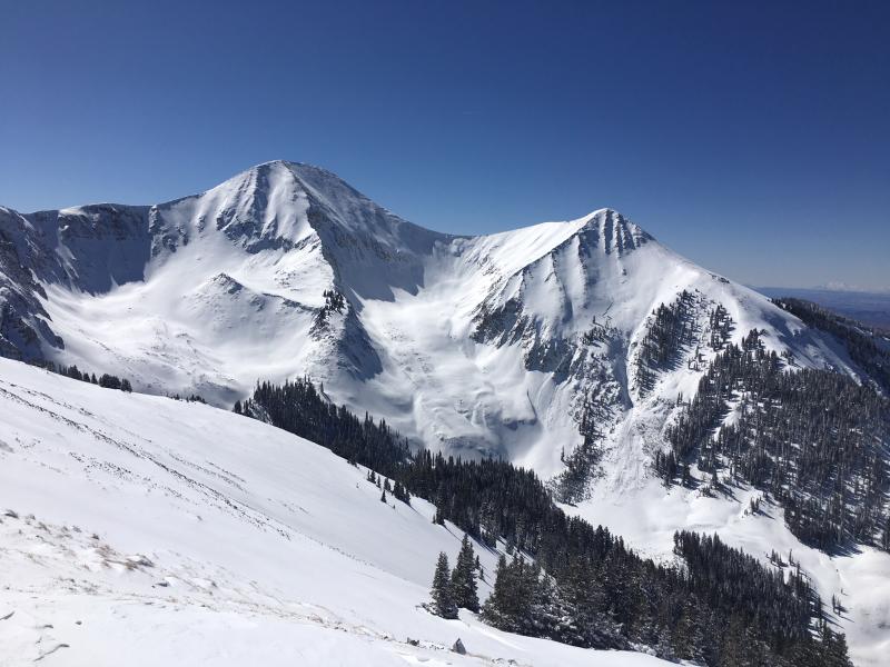
current conditions A couple inches of new snow fell out of a fast moving storm last night bring totals for the week to around 20". Yesterday was a glorious day in the mountains and today will be a repeat performance. Sun exposed slopes grew moist by yesterday afternoon and will be crusted over today, but good powder conditions remain in shletered areas. Conditions are greatly improved but it's still thin up there so use caution and tread lightly. WNW winds are light this morning and it's 10 degrees at the Geyser Pass Trailhead. Base depth in Gold Basin: 42" Base depth at Geyser Pass Trailhead: 30" New snow totals in Gold Basin. Snow totals at the Geyser Pass Trailhead, (9600') Wind, temperature, and humidity on Pre Laurel Peak (11,700') Road conditions to Geyser Pass Trailhead: The road is snowpacked and icy in places. 4wd is recommended. Grooming conditions: Matt groomed all trails yesterday and conditions will be great today!
Another day with views like this is on tap! |
 |
recent activity
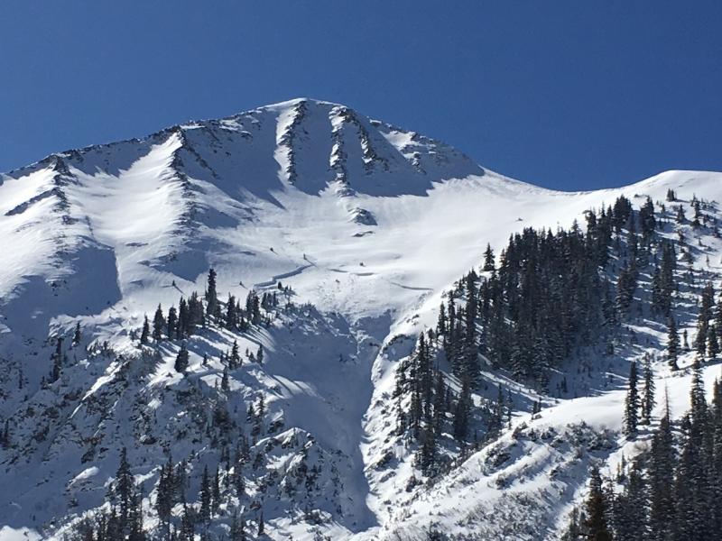
In our travels yesterday we observed this natural avalanche on the NE Face of Tukno AKA Gravel Pit Lanes, that likely released during the storm on Thursday. A wind slab release up high ran down and triggered this deeper and clearly dangerous persistent slab avalanche. Note how it propagates out further left above the cliffs. We observed a few other similar but smaller slides in the area. More details here. |
| type | aspect/elevation | characteristics |
|---|

|

|
LIKELIHOOD
 LIKELY
UNLIKELY
SIZE
 LARGE
SMALL
TREND
 INCREASING DANGER
SAME
DECREASING DANGER
|
|
description
We've added a little more weight to our fragile snowpack this week and stability tests continue to show propagation on weak, sugary, faceted snow at the base. The recent natural acitivity on Thursday clearly illustrates the problem we are dealing with. Time heals, and the snowpack is showing signs of strengthening but there are still many areas where the weight of a skier or rider is all it will take to trigger a deep and dangerous persistent slab avalanche. The danger is greatest on steep slopes, right around treeline and above, that face NW-N-E, especially if these slopes are overloaded with recent deposits of wind drifted snow. For me, the consequences and likliehood of triggering one of these avalanches is still too high and I'll be avoiding these areas for some time. |
| type | aspect/elevation | characteristics |
|---|

|

|
LIKELIHOOD
 LIKELY
UNLIKELY
SIZE
 LARGE
SMALL
TREND
INCREASING DANGER
SAME
DECREASING DANGER
|
|
description
Southerly winds throughout the week have created wind slabs in upper elevation, wind exposed terrain. Most of these slabs have gained strength, but you should continue to avoid any steep slope where the snow has a smooth, rounded appearance, or where you can detect recent deposits of wind drifted snow. The danger is greatest on steep terrain right around treeline and above that faces NW-N-E. In these areas, a triggered wind slab has the very real potential to step down causing a deeper and more dangerous persistent slab avalanche. |
 |
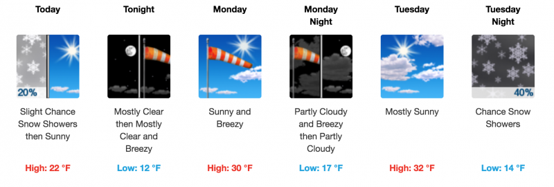
weather Today look for mostly sunny skies with high temps at 10,000' to be in the mid teens. Ridge tops will see a light but cold NW breeze.
|
| general announcements The UAC has new support programs with Outdoor Research and Darn Tough. Support the UAC through your daily shopping. When you shop at Smith's, or online at Outdoor Research, REI, Backcountry.com, Darn Tough, Patagonia, NRS, Amazon, eBay a portion of your purchase will be donated to the FUAC. See our Donate Page for more details on how you can support the UAC when you shop. Benefit the Utah Avalanche Center when you buy or sell on eBay - set the Utah Avalanche Center as a favorite non-profit in your eBay account here and click on eBay gives when you buy or sell. You can choose to have your seller fees donated to the UAC, which doesn't cost you a penny This information does not apply to developed ski areas or highways where avalanche control is normally done. This advisory is from the U.S.D.A. Forest Service, which is solely responsible for its content. This advisory describes general avalanche conditions and local variations always occur. |