25th Annual Black Diamond Fall Fundraising Party
Thursday, September 13; 6:00-10:00 PM; Black Diamond Parking Lot
25th Annual Black Diamond Fall Fundraising Party
Thursday, September 13; 6:00-10:00 PM; Black Diamond Parking Lot
| Advisory: Moab Area Mountains | Issued by Eric Trenbeath for Monday - February 19, 2018 - 6:13am |
|---|

|
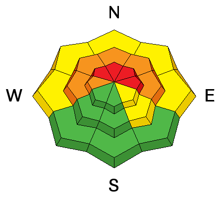
bottom line The avalanche danger is CONSIDERABLE on steep slopes facing W-N-E at mid and upper elevations. Human triggered avalanches are likely and natural avalanches are possible in these areas. If we receive more than forecasted snow amounts, the danger could rise to HIGH later today and backcountry travelers need to be alert to changing conditions. Careful snowpack evaluation, conservative decision making, and excellent route finding skills are essential today. Stay off of and out from under steep, and locally connected terrain, and avoid slopes with recently deposited, wind drifted snow.
|
 |
special announcement Episode 5 of the UAC podcast "To Hell in a Heartbeat - A Conversation With Tom Diegel and Matt Clevenger About the 12.26.08 Full Burial on Little Water" is live. Matt and Tom talk about the avalanche documented in To Hell in a Heartbeat. Check it out on ITunes, Stitcher, the UAC blog. The UAC Marketplace is still open. Our online marketplace still has deals on skis, packs, airbag packs, beacons, snowshoes, soft goods and much more. |
 |
current conditions The story is the wind. Starting yesterday and blowing from the south, ridge top winds have been averaging 30-35 mph with gusts to 60. Gold Basin is reporting just under 2" of snow this morning with no current data available from the Geyser Pass Trailhead. 10,000' temps are in the mid teens. I had high hopes this would be the storm to put us over the top but it appears to be backing off. It looks like we'll see 4-6" over the next 24 hours but we could be surprised. Winds have hammered the high country, and coverage reamins thin. People have started venturing off trail, both on sleds and skis, but it's still very heads up and there are many obstacles and land mines out there. Base depth at Geyser Pass Trailhead: 23" Base depth in Gold Basin: 34" New snow totals in Gold Basin. Snow totals at the Geyser Pass Trailhead, (9600') Wind, temperature, and humidity on Pre Laurel Peak (11,700') Road conditions to Geyser Pass Trailhead: Expect to find a few inches of accumulating and drifted snow increasing through the day. 4wd is required. Grooming conditions: Trails were last groomed on Friday. |
 |
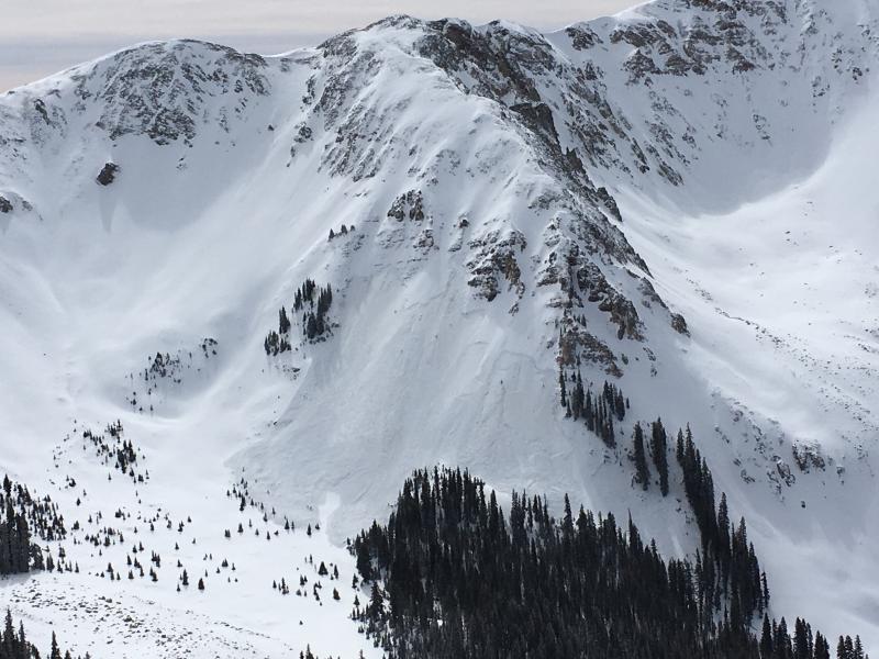
recent activity Dave Garcia observed the first significant avalanche activity of the season in Talking Mountain Cirque. The slides likely occurred on Thursday when the new snow load finally tipped the balance on our weak snowpack. And Justin Caggiano reported a natural avalanche on the North Face of South Mountain. Strong winds and additional snow could produce more natural avalanches such as this, and the weight of a skier or rider will almost certainly do so in this type of terrain.
Natural avalanche in Talking Mountain Cirque. Dave Garcia photo. |
| type | aspect/elevation | characteristics |
|---|

|
|
LIKELIHOOD
 LIKELY
UNLIKELY
SIZE
 LARGE
SMALL
TREND
 INCREASING DANGER
SAME
DECREASING DANGER
|
|
description
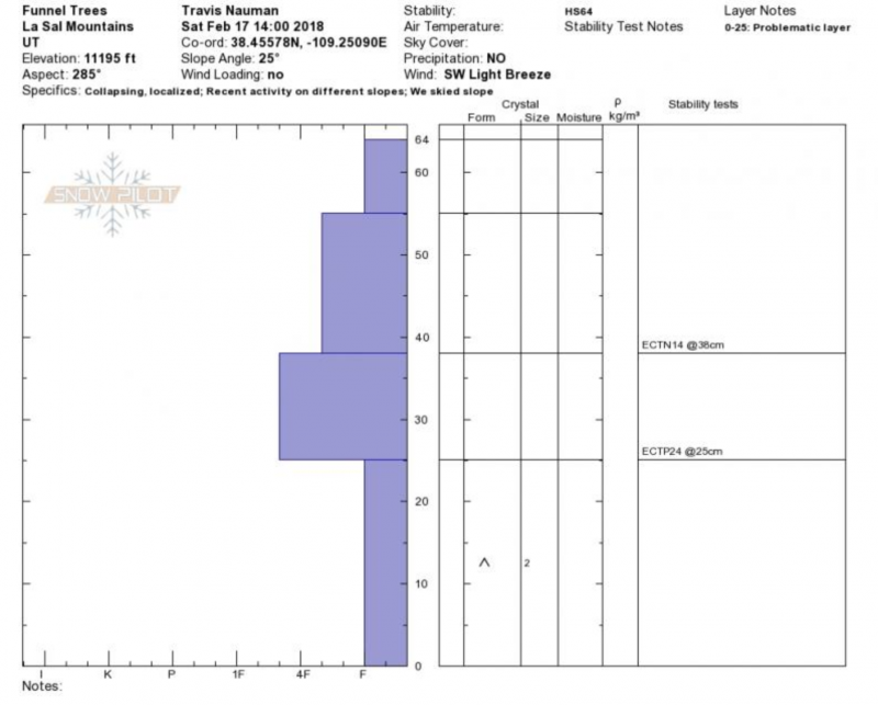
Our current snowpack structure is very weak with loose, sugary, faceted snow at the ground and a couple of buried weak layers higher up in the pack. Incremental loading last week applied enough pressure to produce a few natural avalanches. The approaching storm doesn't seem to be bringing enough new snow load to produce a wide spread avalanche cycle but conditions are tenuous, especially with these winds, and I wouldn't be surprised to see some natural activity. The most unstable snow exists on NW-N-E facing slopes at mid and upper elevations, and human triggered avalanches from 1-3' deep remain likely in these areas. Be alert to rising danger over the next 24 hours, and stay off of, and out from under steep terrain.
Travis Nauman submitted this pit profile that clearly illustrates the unstable base we are dealing with. |
| type | aspect/elevation | characteristics |
|---|

|
|
LIKELIHOOD
LIKELY
UNLIKELY
SIZE
LARGE
SMALL
TREND
INCREASING DANGER
SAME
DECREASING DANGER
|
|
description
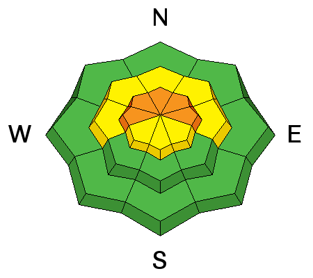
Winds are whipping snow around up there and new wind slabs are forming on the lee sides of ridge crests and terrain features such as gully walls and sub ridges. With the strength of the wind, slabs will also form further down slope than usual and at lower elevations. Wind slab development will become more widespread as snow accumulates creating additional stress on buried weak layers. Avoid all steep slopes with recent deposits of wind drifted snow. |
 |
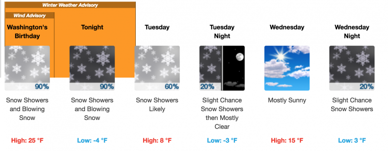
weather The approaching storm system is slowing down and appearing less organized as it reaches our zone and snow totals are backing off. Today expect 2-4" with another 2-4" overnight. SW winds will continue in the 30 - 40 mph range and daytime temps at 10,000' will be in the mid 20's. Very cold temperatures will usher in tonight, dropping below zero and continuing through Tuesday.
|
| general announcements The UAC has new support programs with Outdoor Research and Darn Tough. Support the UAC through your daily shopping. When you shop at Smith's, or online at Outdoor Research, REI, Backcountry.com, Darn Tough, Patagonia, NRS, Amazon, eBay a portion of your purchase will be donated to the FUAC. See our Donate Page for more details on how you can support the UAC when you shop. Benefit the Utah Avalanche Center when you buy or sell on eBay - set the Utah Avalanche Center as a favorite non-profit in your eBay account here and click on eBay gives when you buy or sell. You can choose to have your seller fees donated to the UAC, which doesn't cost you a penny This information does not apply to developed ski areas or highways where avalanche control is normally done. This advisory is from the U.S.D.A. Forest Service, which is solely responsible for its content. This advisory describes general avalanche conditions and local variations always occur. |