25th Annual Black Diamond Fall Fundraising Party
Thursday, September 13; 6:00-10:00 PM; Black Diamond Parking Lot
25th Annual Black Diamond Fall Fundraising Party
Thursday, September 13; 6:00-10:00 PM; Black Diamond Parking Lot
| Advisory: Moab Area Mountains | Issued by Eric Trenbeath for Sunday - February 18, 2018 - 5:57am |
|---|

|
bottom line The avalanche danger remains CONSIDERABLE on steep slopes facing NW-N-E at mid and upper elevations, and human triggered avalanches 1-3' deep are likely in these areas. The danger is expected to rise to HIGH over the next couple of days and backcountry travelers will need to be alert to changing conditions. Careful snowpack evaluation, conservative decision making, and excellent route finding skills are essential. Stay off of and out from under steep and locally connected slopes.
|
 |
avalanche watch THE FOREST SERVICE UTAH AVALANCHE CENTER IN MOAB HAS ISSUED A BACKCOUNTRY AVALANCHE WATCH. * TIMING…IN EFFECT FROM 6 AM MST THIS MORNING TO 6 AM MST MONDAY * AFFECTED AREA…FOR THE LA SAL AND ABAJO MOUNTAINS OF SOUTHEASTERN UTAH * AVALANCHE DANGER…THE AVALANCHE DANGER FOR THE WARNING AREA IS CONSIDERABLE AND IS EXPECTED TO RISE TO HIGH OVERNIGHT. * IMPACTS…STRONG WINDS TODAY WITH PERIODS OF HEAVY SNOW TONIGHT THROUGH TUESDAY WILL CREATE WIDESPREAD AREAS OF UNSTABLE SNOW. THE AVALANCHE DANGER WILL REMAIN ELEVATED THROUGH TUESDAY WITH BOTH HUMAN TRIGGERED AND NATURAL AVALANCHES BECOMING LIKELY. STAY OFF OF AND OUT FROM UNDER SLOPES STEEPER THAN 30 DEGREES. BACKCOUNTRY TRAVELERS SHOULD CONSULT WWW.UTAHAVALANCHECENTER.ORG OR CALL 1-888-999-4019 FOR MORE DETAILED INFORMATION. |
 |
special announcement Episode 5 of the UAC podcast "To Hell in a Heartbeat - A Conversation With Tom Diegel and Matt Clevenger About the 12.26.08 Full Burial on Little Water" is live. Matt and Tom talk about the avalanche documented in To Hell in a Heartbeat. Check it out on ITunes, Stitcher, the UAC blog. The UAC Marketplace is still open. Our online marketplace still has deals on skis, packs, airbag packs, beacons, snowshoes, soft goods and much more. |
 |
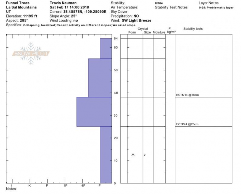
current conditions Skies are clear, temps are mild, and SW winds are on the increase ahead of an approaching storm system that will begin to affect our area later this evening with snow continuing into Tuesday. This could be the storm that finally puts us in there though with a corresponding rise in avalanche danger. Snow has been trickling in since last Saturday, and little by little it's been adding up to a total of 17-20" at 1.5" - 2" water weight. Coverage remains thin but folks on sleds and skis are starting to venture off trail and we finally have a base. Nevertheless, rocks and deadfall still present serious, day ruining obstacles so be carfeul out there! Travis Nuamn and Reed Kennard submitted this observation from their travels yesterday. Base depth at Geyser Pass Trailhead: 23" Base depth in Gold Basin: 34" New snow totals in Gold Basin. Snow totals at the Geyser Pass Trailhead, (9600') Wind, temperature, and humidity on Pre Laurel Peak (11,700') Road conditions to Geyser Pass Trailhead: The road has not been plowed since the last storm. Many vehicles have driven up but 4wd is required. Grooming conditions: Trails were groomed Friday into Gold Basin. |
 |
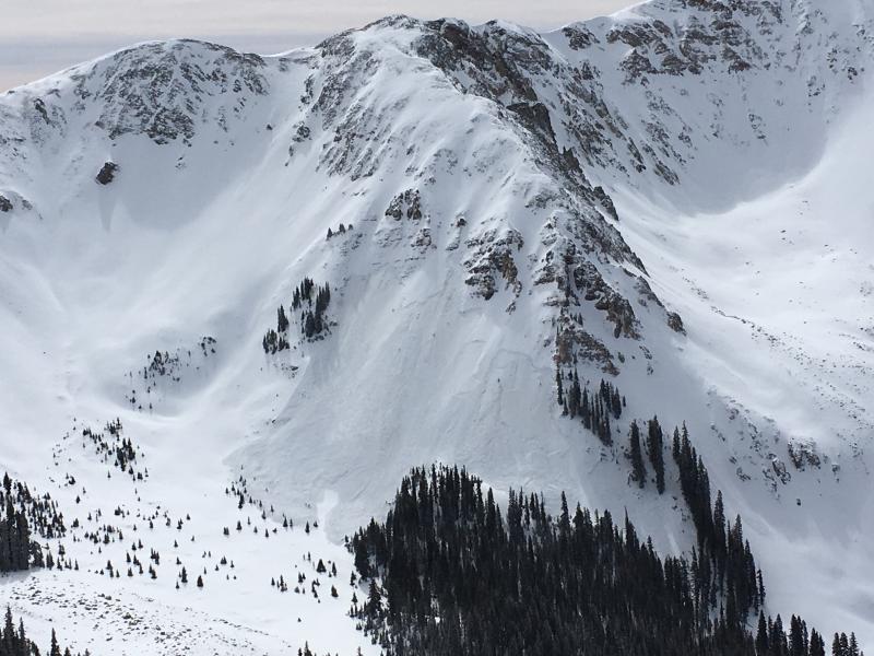
recent activity Dave Garcia observed the first significant avalanche activity of the season in Talking Mountain Cirque. The slides likely occurred on Thursday when the new snow load finally tipped the balance on our weak snowpack. And Justin Caggiano reported a natural avalanche on the North Face of South Mountain. All similar slopes should be considered equally as likely to avalanche with the additional weight of a skier or rider today.
Natural avalanche in Talking Mountain Cirque. Dave Garcia photo. |
| type | aspect/elevation | characteristics |
|---|

|

|
LIKELIHOOD
 LIKELY
UNLIKELY
SIZE
 LARGE
SMALL
TREND
 INCREASING DANGER
SAME
DECREASING DANGER
|
|
description
Incremental loading over the past week has kept the pressure on our fragile snowpack and the incoming storm could provide enough of a load to bring the house down. Unstable snow exists on W-N-E facing slopes at mid and upper elevations, and human triggered avalanches from 1-3' deep remain likely in these areas. Backcountry travelers need to be alert to rising danger over the next couple of days, posess excellent route finding skills, and practice conservative decsison making.
Travis Nauman submitted this pit profile that clearly illustrates the unstable base we are dealing with. |
| type | aspect/elevation | characteristics |
|---|

|
|
LIKELIHOOD
 LIKELY
UNLIKELY
SIZE
LARGE
SMALL
TREND
INCREASING DANGER
SAME
DECREASING DANGER
|
|
description
Wind slabs old, new, and forthcoming present a current and future problem in upper elevation, wind exposed terrain.. Avoid areas that have a smooth, rounded appearance, or that sound hollow under foot. With snow and wind in the forecast the danger will increase. Be on the lookout for recent deposits of wind drifted snow. A triggered wind slab also has the potential to step down creating a deeper, more dangerous, persistent slab avalanche. |
 |
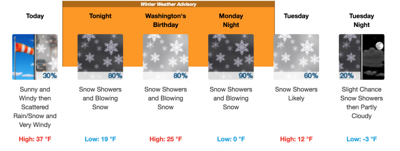
weather Blustery will best describe conditions today as SW winds increase to 20-30 mph with gusts into the 40's ahead of the approaching storm. Clear skies this morning will give way to clouds this afternoon. High temps at 10,000' will be near 30 degrees.
|
| general announcements The UAC has new support programs with Outdoor Research and Darn Tough. Support the UAC through your daily shopping. When you shop at Smith's, or online at Outdoor Research, REI, Backcountry.com, Darn Tough, Patagonia, NRS, Amazon, eBay a portion of your purchase will be donated to the FUAC. See our Donate Page for more details on how you can support the UAC when you shop. Benefit the Utah Avalanche Center when you buy or sell on eBay - set the Utah Avalanche Center as a favorite non-profit in your eBay account here and click on eBay gives when you buy or sell. You can choose to have your seller fees donated to the UAC, which doesn't cost you a penny This information does not apply to developed ski areas or highways where avalanche control is normally done. This advisory is from the U.S.D.A. Forest Service, which is solely responsible for its content. This advisory describes general avalanche conditions and local variations always occur. |