25th Annual Black Diamond Fall Fundraising Party
Thursday, September 13; 6:00-10:00 PM; Black Diamond Parking Lot
25th Annual Black Diamond Fall Fundraising Party
Thursday, September 13; 6:00-10:00 PM; Black Diamond Parking Lot
| Advisory: Moab Area Mountains | Issued by Eric Trenbeath for Tuesday - February 6, 2018 - 7:23am |
|---|

|
bottom line The avalanche danger is MODERATE today and heightened avalanche conditions exist in steep, upper elevation terrain that faces NW-N-SE. Human triggered, persistent slab avalanches up to 2' deep, failing on weak, sugary, faceted snow at the ground are possible in these areas. The danger also exists for triggering a recently deposited wind slab in upper elevation, wind exposed terrain.
|
 |
special announcement Episode 3 of the UAC podcast is live. We talk with UDOT Avalanche Program Supervisor Bill Nalli on how he and his teams keep the Greatest Snow on Earth from avalanching over the open roads and highways of the state. Check it out on ITunes, Stitcher, the UAC blog, or wherever you get your podcasts. The UAC Marketplace is online. The holiday auction is closed, but our online marketplace still has deals on skis, packs, airbag packs, beacons, snowshoes, soft goods and much more. |
 |
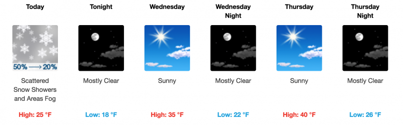
current conditions Miracles never cease. Last night's 50% chance of scattered showers produced 6" of new snow up in the mountains. Overnight, WNW winds averaged 10 mph along ridge tops. They've picked up this morning averaging 15 mph with gusts to 25 from the NW. It's 23 degrees at the Geyser Pass Trailhead and 13 on Pre Laurel Peak. Base depth at Geyser Pass Trailhead: 17" New snow totals in Gold Basin. Snow totals at the Geyser Pass Trailhead, (9600') Wind, temperature, and humidity on Pre Laurel Peak (11,700') Road conditions to Geyser Pass Trailhead: Expect to find a few inches of snow on the road increasing to about 6" at the parking lot. 4wd required. Grooming conditions: Trails will be covered in fresh snow this morning. |
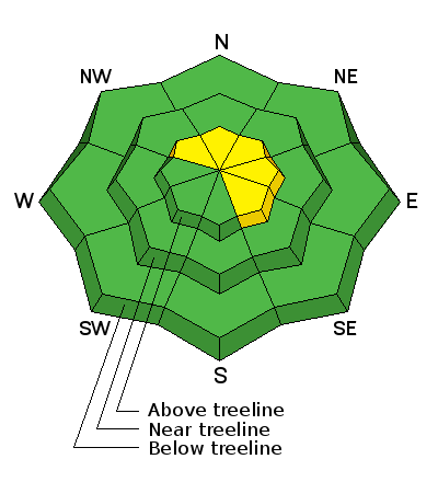
| type | aspect/elevation | characteristics |
|---|

|
|
LIKELIHOOD
 LIKELY
UNLIKELY
SIZE
 LARGE
SMALL
TREND
 INCREASING DANGER
SAME
DECREASING DANGER
|
|
description
Areas of unstable snow exis on steep, NW-N-E facing slopes right around treeline and above where loose, weak, sugary faceted snow at the ground is providing an unstable base. The new snow will add some additonal stress to the ongoing persistent slab danger, and human triggered avalanches up to 2' deep are possible in these areas. |
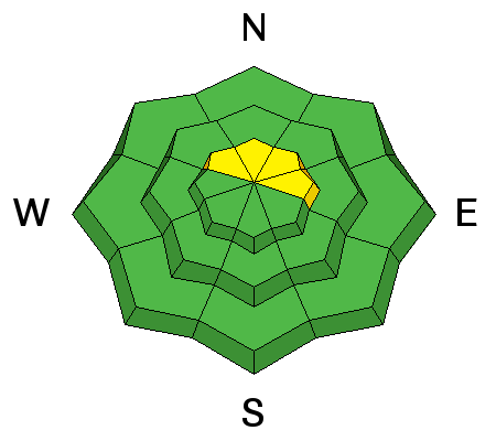
| type | aspect/elevation | characteristics |
|---|

|
|
LIKELIHOOD
LIKELY
UNLIKELY
SIZE
 LARGE
SMALL
TREND
 INCREASING DANGER
SAME
DECREASING DANGER
|
|
description
Today, be on the lookout for fresh wind drifts and wind slabs on the lee sides of ridge crests and terrain features in upper elevation, wind exposed terrain. Look for smooth rounded pillows of recently deposited, wind drifted snow. A triggered wind slab also has the potential to step down creating a deeper and more dangerous persistent slab avalanche. |
 |
weather
|
| general announcements The UAC has new support programs with Outdoor Research and Darn Tough. Support the UAC through your daily shopping. When you shop at Smith's, or online at Outdoor Research, REI, Backcountry.com, Darn Tough, Patagonia, NRS, Amazon, eBay a portion of your purchase will be donated to the FUAC. See our Donate Page for more details on how you can support the UAC when you shop. Benefit the Utah Avalanche Center when you buy or sell on eBay - set the Utah Avalanche Center as a favorite non-profit in your eBay account here and click on eBay gives when you buy or sell. You can choose to have your seller fees donated to the UAC, which doesn't cost you a penny This information does not apply to developed ski areas or highways where avalanche control is normally done. This advisory is from the U.S.D.A. Forest Service, which is solely responsible for its content. This advisory describes general avalanche conditions and local variations always occur. |