25th Annual Black Diamond Fall Fundraising Party
Thursday, September 13; 6:00-10:00 PM; Black Diamond Parking Lot
25th Annual Black Diamond Fall Fundraising Party
Thursday, September 13; 6:00-10:00 PM; Black Diamond Parking Lot
| Advisory: Moab Area Mountains | Issued by Eric Trenbeath for Sunday - January 21, 2018 - 6:45am |
|---|

|
bottom line The avalanche danger is CONSIDERABLE today. Dangerous avalanche conditions exist and human triggered avalanches are likely on steep slopes that face NW-N-E. Natural avalanches are possible. The new snow load has added stress to the fragile underlying snowpack, and increasing winds today will form dangerous drifts in exposed terrain. Backcountry travelers should stay off of and out from under steep slopes today.
|
 |
special announcement We've scheduled our annual Backcountry 101 avalanche course for Feb 2,3. For more information or to register go here. We've also scheduled a Motorized Backcountry 101 for snowmobiles and snowbikes. For more information or to register go here. |
 |
current conditions Skies are cloudy and light snow continues to fall in the mountains. 9" of snow has piled up at the Geyser Pass Trailhead since about 4:00 p.m. yesterday. Pre Laurel winds stopped reporting around midnight but they were light and southwesterly. Abajo Peak and 700mb charts show that winds have shifted to the WNW and are averaging 10 mph. Expect them to be on the increase today. This is finally the storm to kick off winter recreation in the La Sals though coverage is still very thin. Travel will be particularly treacherous today with many obstacles such as rocks and downed trees just covered over with a fresh blanket of snow. Base depth is 18" base at the Geyser Pass Trailhead. Reed Kennard was out yesterday waiting for the approaching storm and submitted this observation. New snow totals in Gold Basin. Snow totals at the Geyser Pass Trailhead, (9600') Wind, temperature, and humidity on Pre Laurel Peak (11,700') |
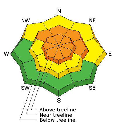
| type | aspect/elevation | characteristics |
|---|

|
|
LIKELIHOOD
 LIKELY
UNLIKELY
SIZE
 LARGE
SMALL
TREND
 INCREASING DANGER
SAME
DECREASING DANGER
|
|
description
Dangerous persistent slab conditions exist on slopes steeper than about 30 degrees that face NW-N-E and backcountry travelers should avoid these areas. Loose, sugary, faceted snow on the ground is providing an unstable base for the new snow load. The telltale sign of instability will be collapsing and whoomphing of the snowpack though this sign may not always present itself. Remotely triggering an avalanche may be possible under these conditons and travelers need to stay out from under steep slopes and be aware of locally connected terrain. |
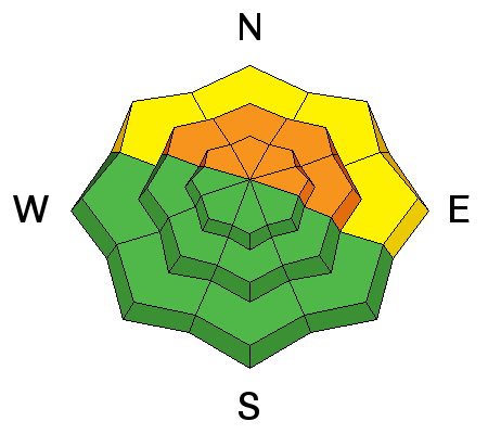
| type | aspect/elevation | characteristics |
|---|

|

|
LIKELIHOOD
LIKELY
UNLIKELY
SIZE
LARGE
SMALL
TREND
 INCREASING DANGER
SAME
DECREASING DANGER
|
|
description
Northwest winds will be on the increase today and with plenty of snow available for transport, wind slabs will be forming on all aspects in upper elevation, wind exposed terrain. A triggered wind slab also has a high potential for stepping down into a buried weak layer causing a deeper, and more dangerous avalanche. Be on the lookout for recent deposits of wind drifted snow that can be recognized by their smooth, rounded appearance. Cracking in the snow surface is a sign of instability and travelers should avoid steep slopes where these signs are present. |
 |
weather
|
| general announcements Support the UAC through your daily shopping. When you shop at Smith's, or online at REI, Backcountry.com, Patagonia, NRS, Amazon, eBay a portion of your purchase will be donated to the FUAC. See our Donate Page for more details on how you can support the UAC when you shop. Benefit the Utah Avalanche Center when you buy or sell on eBay - set the Utah Avalanche Center as a favorite non-profit in your eBay account here and click on eBay gives when you buy or sell. You can choose to have your seller fees donated to the UAC, which doesn't cost you a penny This information does not apply to developed ski areas or highways where avalanche control is normally done. This advisory is from the U.S.D.A. Forest Service, which is solely responsible for its content. This advisory describes general avalanche conditions and local variations always occur. |


