25th Annual Black Diamond Fall Fundraising Party
Thursday, September 13; 6:00-10:00 PM; Black Diamond Parking Lot
25th Annual Black Diamond Fall Fundraising Party
Thursday, September 13; 6:00-10:00 PM; Black Diamond Parking Lot
| Advisory: Moab Area Mountains | Issued by Eric Trenbeath for Sunday - April 9, 2017 - 6:49am |
|---|

|
bottom line The avalanche danger is mostly LOW and generally stable snow conditions exist. Isolated wind slabs may exist on the lee sides of upper elevation ridge crests and terrain features. Cold temperatures and breezy conditions should temper the potential for wet slide activity, but the strong sun may increase the danger for loose, wet avalanches late in the day. Snow surfaces are very hard and slides for life are a real possibility. Consider carrying an ice axe or a whippet for self arrest.
|
 |
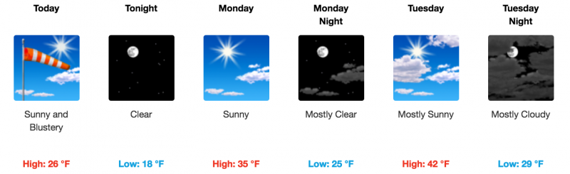
current conditions Skies are clear and 10,000' temperatures are in the teens. Southwest winds have backed off into the 15-20 mph range after howling in the 30's for most of the night. Last night's cold temperatures provided a solid refreeze, and snow conditions today will be a mix of frozen hard, and wind scoured surfaces. Winds, temperature and humidity on Pre Laurel Peak (11,700' Snow totals, temperature and humidity in Gold Basin. (10,000') Snow totals, temperature and snow/water equivalent at Geyser Pass Trailhead. (9600') |
 |
recent activity Other than a few small point releases, no avalanche activity was reported. |
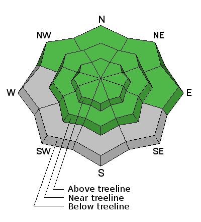
| type | aspect/elevation | characteristics |
|---|

|
|
LIKELIHOOD
 LIKELY
UNLIKELY
SIZE
 LARGE
SMALL
TREND
 INCREASING DANGER
SAME
DECREASING DANGER
|
|
description
The avalanche danger is generally low but mountain travel always requires awareness of objective hazards. Wind slabs - The strong southwesterly winds may have been able to scratch out some snow for transport to create a few isolated wind slabs on upper elevation, leeward slopes. Look for hollow feeling areas of wind deposited snow on the lee sides of ridge crests and terrain features. With the hard snow surfaces out there, even a shallow wind slab could take you for a nasty ride over a cliff. Loose wet avalanches - Breezy conditions and cold temperatures will keep the snow surface from softening for awhile today. But with a strong sun, we may see some loose wet activity this afternoon. Look for signs of instability such roller balls, pinwheels, or sloppy wet snow up around your boot tops. Change your aspect or move higher in elevation if these signs are present. Slide for life - Very hard snow surfaces exist and mountain travelers may want to carry an ice axe, or whippet for self arrest. |
 |
weather Today will be sunny and breezy with cooler than normal temperatures. 10,000' highs will be near 30 degrees. Dry, and gradually warmer weather is on tap through the week with no major storms in sight through the weekend. |
| general announcements If you are getting out into the mountains, we love to hear from you! You can SUBMIT OBSERVATIONS ONLINE If you would like to have avalanche advisories emailed to you, SIGN UP HERE Support the Utah Avalanche Center just by buying groceries! Do you buy groceries at City Market? When you register your Kroger rewards card with their Community Rewards program, they will donate to the Utah Avalanche Center whenever you make a purchase. It's easy, only takes a minute, and doesn't cost you anything. Details here. Benefit the Utah Avalanche Center when you shop from Backcountry.com or REI: Click this link for Backcountry.com or this link to REI, shop, and they will donate a percent of your purchase price to the UAC. Both offer free shipping (with some conditions) so this costs you nothing! The information in this advisory is from the US Forest Service which is solely responsible for its content. This advisory describes general avalanche conditions and local variations always occur. |