25th Annual Black Diamond Fall Fundraising Party
Thursday, September 13; 6:00-10:00 PM; Black Diamond Parking Lot
25th Annual Black Diamond Fall Fundraising Party
Thursday, September 13; 6:00-10:00 PM; Black Diamond Parking Lot
| Advisory: Moab Area Mountains | Issued by Eric Trenbeath for Saturday - April 1, 2017 - 6:58am |
|---|

|
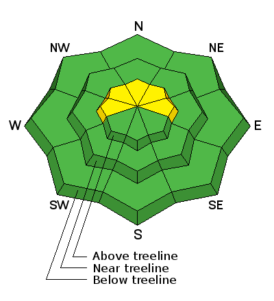
bottom line There is an isolated or MODERATE danger for triggering a shallow wind slab in steep, upper elevation terrain that faces W-N-E. If the sun pokes out we may see a few point release, wet sluffs out of rocky areas. Elsewhere the danger is generally LOW.
|
 |
special announcement The road to the Geyser Pass Trailhead has not been plowed. Expect to find about 4" of snow on the upper end, and a muddy surface down below. |
 |
current conditions
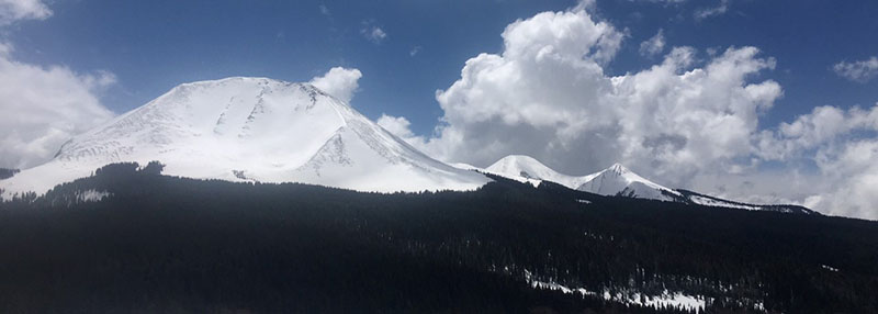
Clouds continue to hang over the mountains this morning as the storm system exits the area. We picked up 4"-6" of new snow, most of it coming in after 4:00 p.m. It was pretty quiet in the mountains yesterday with occasional snow flurries, some partial clearing, and a bit of "green housing" going on where clouds kept in the heat to dampen the snow surface. Winds dropped off after yesterday morning, blowing mostly from the SE in the 10-15 mph from with occasional higher gusts before shifting to more northerly. They've been light overnight but from seemingly all directions and are currently in the single digits from the south. It's currently 26 degrees at the Geyser Pass Trailhead and 16 on Pre Laurel Peak. Snow totals, temperature and snow/water equivalent at Geyser Pass Trailhead. (9600') Winds, temperature and humidity on Pre Laurel Peak (11,700' |
 |
recent activity |
| type | aspect/elevation | characteristics |
|---|

|
|
LIKELIHOOD
 LIKELY
UNLIKELY
SIZE
 LARGE
SMALL
TREND
 INCREASING DANGER
SAME
DECREASING DANGER
|
|
description
Isolated wind slabs formed during the early part of the storm exist along the leeward sides of upper elevation ridge crests and terrain features. Thin, possibly stiff and hollow, they may be covered up by a few inches of newer snow. In most cases they shouldn't pose much of a threat but be mindful of consequences in areas of more extreme terrain, where a triggered wind slab could sweep you off your feet and carry you over a cliff. Be wary of smooth rounded deposits of wind drifted snow, or areas that feel or sound hollow like a drum. |
 |
weather Residual clouds will hang over the mountains today with a few isolated flurries possible. ESE winds will average 10-15 mph shifting to northerly by this afternoon. High temperatures at 10,000' will be in the low 30's. |
| general announcements If you are getting out into the mountains, we love to hear from you! You can SUBMIT OBSERVATIONS ONLINE If you would like to have avalanche advisories emailed to you, SIGN UP HERE Support the Utah Avalanche Center just by buying groceries! Do you buy groceries at City Market? When you register your Kroger rewards card with their Community Rewards program, they will donate to the Utah Avalanche Center whenever you make a purchase. It's easy, only takes a minute, and doesn't cost you anything. Details here. Benefit the Utah Avalanche Center when you shop from Backcountry.com or REI: Click this link for Backcountry.com or this link to REI, shop, and they will donate a percent of your purchase price to the UAC. Both offer free shipping (with some conditions) so this costs you nothing! The information in this advisory is from the US Forest Service which is solely responsible for its content. This advisory describes general avalanche conditions and local variations always occur. |