25th Annual Black Diamond Fall Fundraising Party
Thursday, September 13; 6:00-10:00 PM; Black Diamond Parking Lot
25th Annual Black Diamond Fall Fundraising Party
Thursday, September 13; 6:00-10:00 PM; Black Diamond Parking Lot
| Advisory: Moab Area Mountains | Issued by Eric Trenbeath for Wednesday - March 29, 2017 - 6:42am |
|---|

|
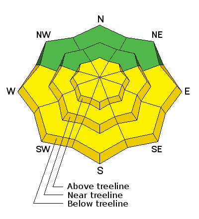
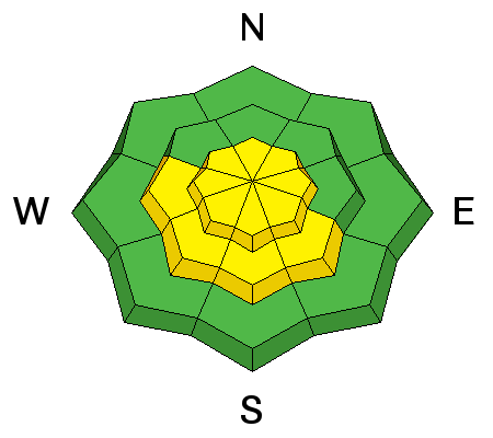
bottom line The avalanche danger is a solid MODERATE today with many wind slabs in the high country that will be ripe for a human trigger. This danger may extend to below tree line in open areas. Avoid steep slopes that have recent deposits of wind drifted snow or that have a hollow sound or feel to them. On wind sheltered, mid and lower elevation slopes the danger is generally LOW. With daytime heating, the danger will rise to MODERATE on steep sun exposed slopes. Look for signs of instability such as roller balls, pinwheels, and sloppy wet snow. Stay off of, and out from under steep slopes when these signs are present.
|
 |
special announcement The road to the Geyser Pass Trailhead has not been plowed and as much as 6" of snow exists on the upper half towards the parking lot. Several vehicles made it up yesterday and there is a two track pushed though down to the dirt. Overnight winds may have caused some drifting in places, and with daytime heating, it will get sloppy and muddy. |
 |
current conditions Skies are clearing, 10,000' temps are in the mid teens, but the story I'm afraid, is the wind. Picking up yesterday afternoon, NNE winds have been blowing all night averaging 20-25 mph with gusts as high as 60 mph. Yesterday's excellent powder conditions will have taken a hit in upper elevation, wind exposed areas. The good news is that we've had more than a foot of snow fall since Sunday, and sheltered locations will still offer good riding and turning conditions. Snow totals, temperature and snow/water equivalent at Geyser Pass Trailhead. (9600') Winds, temperature and humidity on Pre Laurel Peak (11,700' |
 |
recent activity In my travels yesterday I observed several loose dry sluffs on steep, northerly aspects. |
| type | aspect/elevation | characteristics |
|---|

|
|
LIKELIHOOD
 LIKELY
UNLIKELY
SIZE
 LARGE
SMALL
TREND
 INCREASING DANGER
SAME
DECREASING DANGER
|
|
description
Ridgecrest slabs were beginning to form as winds increased late yesterday afternoon. With the intensity of last night's wind, I expect slabs to be more widespread today and ripe for a human trigger. Keep in mind that unusual wind directions deposit wind slabs in unusual places. Slopes with a westerly component will be the most suspect but cross loading will be a factor on all aspects in the extreme upper elevations. Look for smooth rounded deposits of wind drifted snow on the lee sides of ridge crests and terrain features and avoid steep slopes where they are present. |
| type | aspect/elevation | characteristics |
|---|

|
|
LIKELIHOOD
LIKELY
UNLIKELY
SIZE
 LARGE
SMALL
TREND
 INCREASING DANGER
SAME
DECREASING DANGER
|
|
description
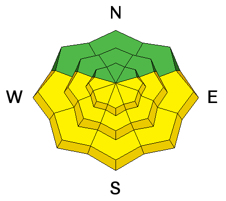
Dry powder snow rapidly becomes unstable when it gets hit by a strong sun for the first time. With daytime heating, the danger for loose, wet avalanches will rise on sun exposed slopes. Be alert to signs of instability such as roller balls or pinwheels and sloppy wet snow. Stay off of and out from under steep slopes when these signs are present. |
 |
weather Today Areas of blowing snow before 11am. Patchy fog before 8am. Otherwise, sunny, with a high near 36. Breezy, with a north wind 15 to 20 mph decreasing to 10 to 15 mph in the afternoon. Winds could gust as high as 30 mph. Tonight Mostly clear, with a low around 28. North northwest wind 5 to 15 mph. Thursday A chance of rain, with thunderstorms also possible after 3pm. Partly sunny, with a high near 42. West wind 5 to 15 mph becoming south southwest in the afternoon. Winds could gust as high as 25 mph. Chance of precipitation is 50%. Thursday Night Rain likely before 7pm, then rain and snow likely between 7pm and 9pm, then snow likely after 9pm. Some thunder is also possible. Patchy blowing snow between 1am and 2am. Cloudy, with a low around 21. Breezy, with a south southwest wind 15 to 20 mph, with gusts as high as 30 mph. Chance of precipitation is 70%. New snow accumulation of 3 to 5 inches possible. Friday Snow likely. Some thunder is also possible. Cloudy, with a high near 30. South wind 10 to 15 mph becoming north northeast in the afternoon. Chance of precipitation is 70%. Friday Night Snow likely. Mostly cloudy, with a low around 21. Chance of precipitation is 60%. Saturday A 40 percent chance of snow. Patchy blowing snow after 5pm. Partly sunny, with a high near 34. |
| general announcements If you are getting out into the mountains, we love to hear from you! You can SUBMIT OBSERVATIONS ONLINE If you would like to have avalanche advisories emailed to you, SIGN UP HERE Support the Utah Avalanche Center just by buying groceries! Do you buy groceries at City Market? When you register your Kroger rewards card with their Community Rewards program, they will donate to the Utah Avalanche Center whenever you make a purchase. It's easy, only takes a minute, and doesn't cost you anything. Details here. Benefit the Utah Avalanche Center when you shop from Backcountry.com or REI: Click this link for Backcountry.com or this link to REI, shop, and they will donate a percent of your purchase price to the UAC. Both offer free shipping (with some conditions) so this costs you nothing! The information in this advisory is from the US Forest Service which is solely responsible for its content. This advisory describes general avalanche conditions and local variations always occur. |


