25th Annual Black Diamond Fall Fundraising Party
Thursday, September 13; 6:00-10:00 PM; Black Diamond Parking Lot
25th Annual Black Diamond Fall Fundraising Party
Thursday, September 13; 6:00-10:00 PM; Black Diamond Parking Lot
| Advisory: Moab Area Mountains | Issued by Eric Trenbeath for Saturday - March 25, 2017 - 6:58am |
|---|

|
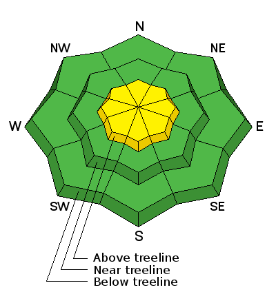
bottom line Today there is a MODERATE danger for wind slab avalanches in upper elevation, wind exposed terrain. Look for smooth rounded deposits of wind drifted snow on the leeward sides of ridge crests and terrain features. Pay attention to consequences, even a shallow slab could take you for a nasty ride over rocks and cliffs in areas of more radical terrain. Mid and lower elevations offer mostly LOW danger.
|
 |
current conditions High clouds are starting to move in from the west, southerly ridgetop winds are averaging 20 mph along ridge tops, and 10,000' temperatures are in the low 30's. Strong northwest winds yesterday wreaked havoc on the 5" of new snow we received on Thursday night, and a strong sun added insult to injury. You will have to seek out sheltered terrain for decent powder conditions today. Traditionally a wet month, March has been tough on our snowpack and we are currently at 77% of normal, with 57" on the ground in Gold Basin. Many south facing slopes are melted out to the rocks, and the snow line has crept up to around 9000'. Wind, temperature and humidity on Pre Laurel Peak. (11,700') Storm totals and temperature in Gold Basin. (10,000') Snow totals, temperature and snow/water equivalent at the Geyser Pass Trailhead. (9600') |
 |
recent activity |
| type | aspect/elevation | characteristics |
|---|

|
|
LIKELIHOOD
 LIKELY
UNLIKELY
SIZE
 LARGE
SMALL
TREND
 INCREASING DANGER
SAME
DECREASING DANGER
|
|
description
Wind slabs formed yesterday may still be sensitive to the weight of a skier or rider. Look for them on the lee sides of ridge crests and terrain features in upper elevation, wind exposed terrain. Suspect steep slopes with smooth, rounded deposits of wind drifted snow, and avoid areas with a hollow feel to them. Pay attention to consequences, even a shallow slab could take you for a nasty ride over rocks and cliffs in areas of more radical terrain. |
 |
weather Mostly clear skies this morning will give way to clouds this afternoon as the next weak storm system moves into our area. We may see an inch or two of new snow later in the day. Southwesterly ridge top winds will blow in the 20-30 mph range. Daytime high temperatures will be in the low 30's at 10,000'. Sunday will see some clearing before and active pattern sets in for next week. |
| general announcements
If you are getting out into the mountains, we love to hear from you! You can SUBMIT OBSERVATIONS ONLINE If you would like to have avalanche advisories emailed to you, SIGN UP HERE Support the Utah Avalanche Center just by buying groceries! Do you buy groceries at City Market? When you register your Kroger rewards card with their Community Rewards program, they will donate to the Utah Avalanche Center whenever you make a purchase. It's easy, only takes a minute, and doesn't cost you anything. Details here. Benefit the Utah Avalanche Center when you shop from Backcountry.com or REI: Click this link for Backcountry.com or this link to REI, shop, and they will donate a percent of your purchase price to the UAC. Both offer free shipping (with some conditions) so this costs you nothing! The information in this advisory is from the US Forest Service which is solely responsible for its content. This advisory describes general avalanche conditions and local variations always occur. |


