25th Annual Black Diamond Fall Fundraising Party
Thursday, September 13; 6:00-10:00 PM; Black Diamond Parking Lot
25th Annual Black Diamond Fall Fundraising Party
Thursday, September 13; 6:00-10:00 PM; Black Diamond Parking Lot
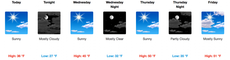
| Advisory: Moab Area Mountains | Issued by Eric Trenbeath for Tuesday - March 7, 2017 - 7:04am |
|---|

|
bottom line The avalanche danger is MODERATE today on steep, wind drifted slopes that face primarily NW-N-E. Suspect slopes with smooth, rounded deposits of wind drifted snow, or that feel hollow like a drum. There also remains an isolated, or MODERATE danger for triggering an avalanche on a buried weak layer on steep slopes right around tree line and above that face NW-N-E.
|
 |
special announcement Road Conditions: Grand County plowed the road to Geyser Pass Trailhead on Monday. Banff Mountain Film Festival World Tour Returns to Moab, Monday, March 13. Featuring the year’s best films on mountain sport, culture and adventure, this will be the 14th season the festival has come to Moab. Proceeds support the Utah Avalanche Center - Moab and Second Chance Wildlife Rehabilitation. For more info and to purchase tickets, go here. Lost Skis: A guest from Talking Mountain Yurts left a pair of blue DPS skis with Dynafit bindings at Geyser Pass Trailhead on Monday. Please call Will at 435-260-7601 if you picked them up. Local skier Craig Bigler lost a ski in the North Woods. If you run across it pleas call him at 435-260-1007 |
 |
current conditions The mountains picked up 4"-6" of new snow on Sunday night. Southerly winds howled leading up to the storm. For the past 24 hours they've been pretty well behaved, and westerly, averaging 15-20 mph along ridgetops. It's 2 degrees on Pre Laurel Peak and 13 at the Geyser Pass Trailhead. Wind, temperature and humidity on Pre Laurel Peak. (11,700') Storm totals and temperature in Gold Basin. (10,000') Snow totals, temperature and snow/water equivalent at the Geyser Pass Trailhead. (9600') |
 |
recent activity |
| type | aspect/elevation | characteristics |
|---|

|
|
LIKELIHOOD
 LIKELY
UNLIKELY
SIZE
 LARGE
SMALL
TREND
 INCREASING DANGER
SAME
DECREASING DANGER
|
|
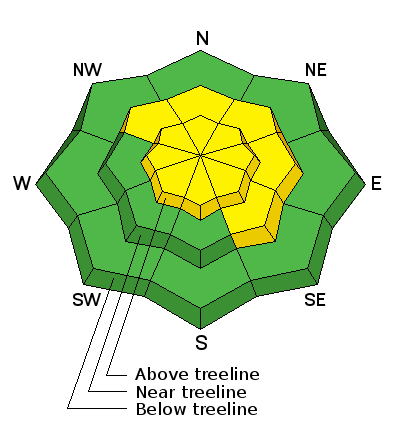
description
Wind slabs formed over the past couple of days are gaining strength, and most were relatively shallow to begin with. But you may still find a few unstable drifts out there on the lee sides of ridge crests and terrain features in wind exposed terrain. Crossloading has been a factor, and with the strong winds, slabs have formed further down slope than usual. Continue to suspect steep slopes with recent deposits of wind drifted snow, as well as areas that feel hollow like a drum. |
| type | aspect/elevation | characteristics |
|---|

|

|
LIKELIHOOD
 LIKELY
UNLIKELY
SIZE
LARGE
SMALL
TREND
INCREASING DANGER
SAME
DECREASING DANGER
|
|
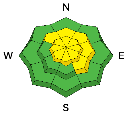
description
The chances of triggering an avalanche on a buried weak layer are decreasing, but today the possiblity exists for a triggered wind slab to step down to a buried weak layer causing a deeper and more dangerous avalanche. You are most likely to encounter this problem on steep, NW-N-E aspects, right around treeline and above. |
 |
weather Increasingly warm and dry weather is on tap for the remainder of the week.
|
| general announcements Grooming: Trails are covered in fresh snow. If you are getting out into the mountains, we love to hear from you! You can SUBMIT OBSERVATIONS ONLINE If you would like to have avalanche advisories emailed to you, SIGN UP HERE Support the Utah Avalanche Center just by buying groceries! Do you buy groceries at City Market? When you register your Kroger rewards card with their Community Rewards program, they will donate to the Utah Avalanche Center whenever you make a purchase. It's easy, only takes a minute, and doesn't cost you anything. Details here. Benefit the Utah Avalanche Center when you shop from Backcountry.com or REI: Click this link for Backcountry.com or this link to REI, shop, and they will donate a percent of your purchase price to the UAC. Both offer free shipping (with some conditions) so this costs you nothing! The information in this advisory is from the US Forest Service which is solely responsible for its content. This advisory describes general avalanche conditions and local variations always occur. |