25th Annual Black Diamond Fall Fundraising Party
Thursday, September 13; 6:00-10:00 PM; Black Diamond Parking Lot
25th Annual Black Diamond Fall Fundraising Party
Thursday, September 13; 6:00-10:00 PM; Black Diamond Parking Lot
| Advisory: Moab Area Mountains | Issued by Eric Trenbeath for Saturday - February 25, 2017 - 6:43am |
|---|

|
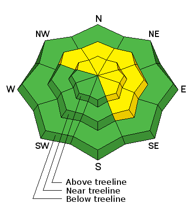
bottom line There remains a MODERATE danger for triggering wind slabs old and new on steep, wind drifted slopes that face NW-N-SE. Time and cold temperatures have helped lock many of these slabs into place, but ominous pillows of wind drifted snow still exist on the leeward sides of ridge crests and terrain features right around tree line and above. Continue to avoid, steep, wind drifted slopes. Pay special attention to heavily featured slopes, or those that have steep convexities or blind break overs. Low elevations and more sheltered terrain offer mostly LOW danger.
|
 |
special announcement Earlier this month, Colorado experienced a snowbike fatality. This is the newest user group to venture into avalanche terrain, and we have several snowbikes here in Moab. It's a tragic story, and a complex situation where the victim had an airbag but wasn't wearing a beacon. Read the story in the official report from the Colorado Avalanche Information Center. |
 |
current conditions Skies are clear this morning and it is again frigid out with below zero temperatures above 10,000'. Westerly winds are averaging 10-15 mph along ridge tops with gusts to 20. Another inch or two of snow has trickled in over the past 24 hours bringing totals since Wednesday up to about 7". Conditions have improved but you can still feel the underlying snow surface on most slopes. Stick to sheltered, and even lower angle terrain for the softest conditions. For recent observations go here. Wind, temperature and humidity on Pre Laurel Peak. (11,700') Storm totals and temperature in Gold Basin. (10,000') Snow totals, temperature and snow/water equivalent at the Geyser Pass Trailhead. (9600') |
 |
recent activity |
| type | aspect/elevation | characteristics |
|---|

|
|
LIKELIHOOD
 LIKELY
UNLIKELY
SIZE
 LARGE
SMALL
TREND
 INCREASING DANGER
SAME
DECREASING DANGER
|
|
description
Wind slabs formed on Thursday have had a few days to gain strength, and the cold temperatures have also helped lock them in place, but I don't think it is quite time to push the envelope into more extreme terrain. Continue to avoid steep, wind drifted slopes right around tree line and above. Pay special attention to heavily featured slopes, or those that have steep convexities or blind break overs. |
 |
weather Today look for mostly sunny skies and cold temperatures with a high of around 15 degrees at 10,000'. Southwest ridge top winds will blow in the 10-15 mph range. We may see a few developing clouds and some convective showers as we ride an unstable westerly flow through Sunday. The next system and chance for real snow arrives on Monday. |
| general announcements Road conditions: The road to Geyser Pass Trailhead has not been plowed this week but vehicles with all wheel drive shouldn't enounter any problems. Expect snow packed conditions. Longtime local skier Craig Bigler lost a ski in the North Woods on Thursday. If you run across it please give him a call at 435-260-1007. If you are getting out into the mountains, we love to hear from you! You can SUBMIT OBSERVATIONS ONLINE If you would like to have avalanche advisories emailed to you, SIGN UP HERE Support the Utah Avalanche Center just by buying groceries! Do you buy groceries at City Market? When you register your Kroger rewards card with their Community Rewards program, they will donate to the Utah Avalanche Center whenever you make a purchase. It's easy, only takes a minute, and doesn't cost you anything. Details here. Benefit the Utah Avalanche Center when you shop from Backcountry.com or REI: Click this link for Backcountry.com or this link to REI, shop, and they will donate a percent of your purchase price to the UAC. Both offer free shipping (with some conditions) so this costs you nothing! The information in this advisory is from the US Forest Service which is solely responsible for its content. This advisory describes general avalanche conditions and local variations always occur. |


