25th Annual Black Diamond Fall Fundraising Party
Thursday, September 13; 6:00-10:00 PM; Black Diamond Parking Lot
25th Annual Black Diamond Fall Fundraising Party
Thursday, September 13; 6:00-10:00 PM; Black Diamond Parking Lot
| Advisory: Moab Area Mountains | Issued by Eric Trenbeath for Sunday - February 19, 2017 - 6:45am |
|---|

|
bottom line Today there is a MODERATE danger for wind slab avalanches in upper elevation, wind exposed terrain, primarily on slopes that face W-N-E. Fresh drifts along ridge crests will be sensitive to skiers and riders in these areas today. There is also a MODERATE danger for loose, dry sluffs, or soft slab avalanches within the storm snow on all aspects on slopes steeper than 35 degrees.
|
 |
special announcement Longtime local skier Craig Bigler lost a ski in the North Woods on Thursday. If you run across it please give him a call at 435-260-1007. |
 |
current conditions It was a snowy and blustery day in the mountains yesterday, and a repeat performance of last weekend. 6" of dense, new snow has fallen in Gold Basin with 3" at the Geyser Pass Trailhead. Another 3"-5" is in the forecast today. SE ridge top winds cranked all day, and continue to do so in the 25-30 mph range with gusts into the 40's. It's currently 21 degrees on Pre Laurel Peak, and just below freezing at the Geyser Pass Trailhead. Ryan Cutter was up again yesterday and sent in this observation. Wind, temperature and humidity on Pre Laurel Peak. (11,700') Storm totals and temperature in Gold Basin. (10,000') Snow totals, temperature and snow/water equivalent at the Geyser Pass Trailhead. (9600') |
 |
recent activity |
| type | aspect/elevation | characteristics |
|---|

|

|
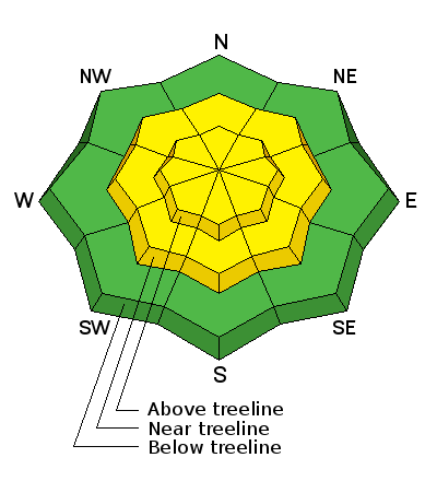
LIKELIHOOD
 LIKELY
UNLIKELY
SIZE
 LARGE
SMALL
TREND
 INCREASING DANGER
SAME
DECREASING DANGER
|
|
description
Newly formed wind slabs in upper elevation, wind exposed terrain will be your primary concern today. Expect to find them on the leeward sides of ridge crests and terrain features such as gully walls, and sub-ridges, on slopes that face W-N-E. Look for signs of instability such as cracking in the snow surface, and avoid steep slopes with smooth, rounded deposits of wind drifted snow. |
| type | aspect/elevation | characteristics |
|---|

|
|
LIKELIHOOD
LIKELY
UNLIKELY
SIZE
 LARGE
SMALL
TREND
INCREASING DANGER
SAME
DECREASING DANGER
|
|
description
Today you may be able to trigger a long running, loose dry sluff, or soft cohesive slab within the storm snow on slopes steeper than about 35 degrees. These should be small, and mostly predictable, but you'll want to put in a slope cut before committing to steeper terrain. |
 |
weather We'll see a brief lull this morning before the next wave begins to affect our area just before noon. 3"-5" is possible today. Southerly ridge top winds will be in the 15-20 mph range, and high temperatures at 10,000' will be in the low 30's. Drier conditions return on Monday before the next in a series of systems moves into the area on Tuesday. |
| general announcements Road conditions: Expect to find a few inches of snow on the road at the upper end with somewhat sloppy an muddy conditions down low. If you are getting out into the mountains, we love to hear from you! You can SUBMIT OBSERVATIONS ONLINE If you would like to have avalanche advisories emailed to you, SIGN UP HERE Support the Utah Avalanche Center just by buying groceries! Do you buy groceries at City Market? When you register your Kroger rewards card with their Community Rewards program, they will donate to the Utah Avalanche Center whenever you make a purchase. It's easy, only takes a minute, and doesn't cost you anything. Details here. Benefit the Utah Avalanche Center when you shop from Backcountry.com or REI: Click this link for Backcountry.com or this link to REI, shop, and they will donate a percent of your purchase price to the UAC. Both offer free shipping (with some conditions) so this costs you nothing! The information in this advisory is from the US Forest Service which is solely responsible for its content. This advisory describes general avalanche conditions and local variations always occur. |


