25th Annual Black Diamond Fall Fundraising Party
Thursday, September 13; 6:00-10:00 PM; Black Diamond Parking Lot
25th Annual Black Diamond Fall Fundraising Party
Thursday, September 13; 6:00-10:00 PM; Black Diamond Parking Lot
| Advisory: Moab Area Mountains | Issued by Eric Trenbeath for Sunday - February 5, 2017 - 6:49am |
|---|

|
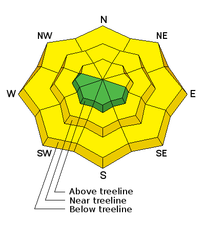
bottom line An isolated, or MODERATE danger still exist on steep slopes that face NW-N-E right around tree line and above where stiff, shallow wind slabs can be found on the lee sides of ridge crests and terrain features such as gully walls or rock buttresses. Though far from widespread, there also remains a MODERATE danger for triggering a deeper, persistent slab avalanche, primarily on steep, northerly facing aspects where the snow pack is relatively shallow. And finally, with daytime heating, sun exposed slopes and low elevation, northerly aspects will become wet and sloppy, and there will be a MODERATE danger for loose, wet avalanches.
|
 |
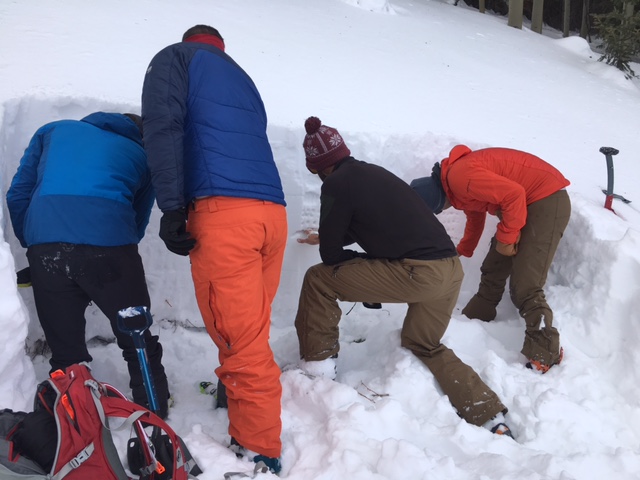
special announcement Thanks to all who participated making our Backcountry 101 class a success!
|
 |
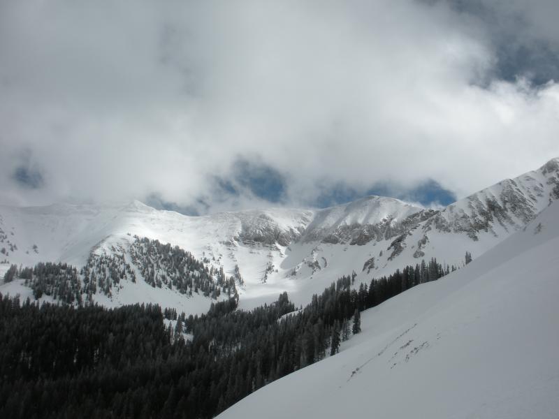
current conditions It's been almost two weeks since our last significant snowfall and the snow surface varies from wind blasted to sun crusted, with spotty areas of soft, settled powder in sheltered mid and lower elevations. Southerly winds are back at it again averaging 20 - 25 mph along ridge tops. It's 19 degrees on Pre Laurel Peak and 30 at the Geyser Pass Trailhead. Reed Kennard was out and about yesterday, check out his report here. Base depth in Gold Basin: 67" Season total snowfall: 160" Percentage of normal: 170% Wind, temperature and humidity on Pre Laurel Peak. (11,700') Storm totals and temperature in Gold Basin. (10,000') Snow totals, temperature and snow/water equivalent at the Geyser Pass Trailhead. (9600')
At least it's still beautiful up there! (Reed Kennard photo) |
 |
recent activity |
| type | aspect/elevation | characteristics |
|---|

|
|
LIKELIHOOD
 LIKELY
UNLIKELY
SIZE
 LARGE
SMALL
TREND
 INCREASING DANGER
SAME
DECREASING DANGER
|
|
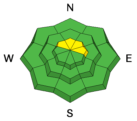
description
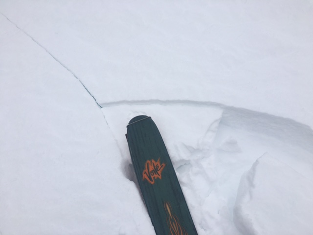
Isolated wind slabs continue to be found lurking about in upper elevation, wind exposed terrain. Look for signs of cracking in the snow surface, and suspect smooth, hollow feeling areas of wind deposited snow. You are most likely to find them on the lee sides of ridge crests and terrain features such as gully walls, sub-ridges and rock buttresses.
Cracking in the snow surface is a sure sign of wind slab. |
| type | aspect/elevation | characteristics |
|---|

|
|
LIKELIHOOD
LIKELY
UNLIKELY
SIZE
 LARGE
SMALL
TREND
 INCREASING DANGER
SAME
DECREASING DANGER
|
|
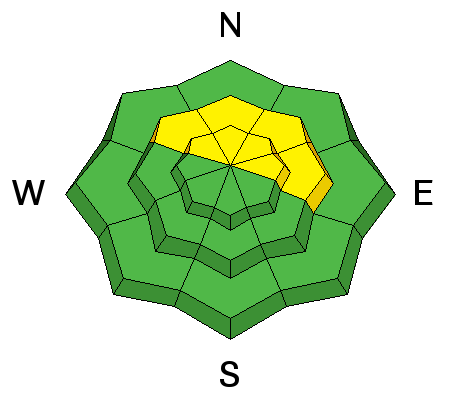
description
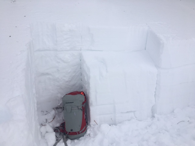
Most snowpits reveal a generally strong snowpack, but isolated slopes still display weak layers of faceted snow. During the Backcountry 101 class on Saturday, we were able to identify a reactive weak layer on a northwest aspect around 10,000'. Though this problem isn't widespread, it means that steep terrain, particularly on northerly aspects where the snowpack is still relatively shallow, warrants caution. |
| type | aspect/elevation | characteristics |
|---|

|
|
LIKELIHOOD
LIKELY
UNLIKELY
SIZE
LARGE
SMALL
TREND
 INCREASING DANGER
SAME
DECREASING DANGER
|
|
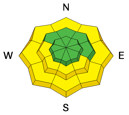
description
With daytime heating, sun exposed slopes and low elevation, northerly aspects will become wet and sloppy, and there will be an increasing danger for loose, wet avalanches. |
 |
weather Mostly sunny skies will prevail today, but clouds will start moving in this afternoon ahead of an approaching Pacific storm system that will affect our area on Monday. Today Mostly sunny, with a high near 32. Southwest wind 10 to 15 mph. Tonight Snow likely, mainly after 4am. Mostly cloudy, with a low around 19. Breezy, with a south wind 15 to 20 mph, with gusts as high as 30 mph. Chance of precipitation is 60%. New snow accumulation of less than one inch possible. Monday Snow likely. Cloudy, with a high near 21. Breezy, with a west southwest wind 20 to 25 mph, with gusts as high as 40 mph. Chance of precipitation is 70%. New snow accumulation of 2 to 4 inches possible. Monday Night Snow likely, mainly after 11pm. Mostly cloudy, with a low around 21. Breezy, with a west southwest wind around 20 mph, with gusts as high as 35 mph. Chance of precipitation is 60%. New snow accumulation of 2 to 4 inches possible. Tuesday Snow likely, mainly before 11am. Cloudy, with a high near 26. Breezy, with a west southwest wind 15 to 20 mph, with gusts as high as 35 mph. Chance of precipitation is 60%. Tuesday Night A 40 percent chance of snow. Mostly cloudy, with a low around 24. Breezy. Wednesday A 40 percent chance of snow. Mostly cloudy, with a high near 32. Breezy. |
| general announcements Road conditions: Thanks to plow crews from the Manti-La Sal National Forest for getting up there on Tuesday and widening the road. If you are getting out into the mountains, we love to hear from you! You can SUBMIT OBSERVATIONS ONLINE If you would like to have avalanche advisories emailed to you, SIGN UP HERE Support the Utah Avalanche Center just by buying groceries! Do you buy groceries at City Market? When you register your Kroger rewards card with their Community Rewards program, they will donate to the Utah Avalanche Center whenever you make a purchase. It's easy, only takes a minute, and doesn't cost you anything. Details here. Benefit the Utah Avalanche Center when you shop from Backcountry.com or REI: Click this link for Backcountry.com or this link to REI, shop, and they will donate a percent of your purchase price to the UAC. Both offer free shipping (with some conditions) so this costs you nothing! The information in this advisory is from the US Forest Service which is solely responsible for its content. This advisory describes general avalanche conditions and local variations always occur. |