25th Annual Black Diamond Fall Fundraising Party
Thursday, September 13; 6:00-10:00 PM; Black Diamond Parking Lot
25th Annual Black Diamond Fall Fundraising Party
Thursday, September 13; 6:00-10:00 PM; Black Diamond Parking Lot
| Advisory: Moab Area Mountains | Issued by Eric Trenbeath for Sunday - January 29, 2017 - 6:50am |
|---|

|
bottom line Today there is a MODERATE avalanche danger for triggering wind slabs old and new on all aspects in steep, upper elevation, wind exposed terrain. There is also an isolated MODERATE danger for triggering a deeper, persistent slab avalanche on slopes steeper than 35 degrees, at mid and upper elevations on slopes facing NW-E-SE. And finally, with daytime heating, a MODERATE danger exists for loose, wet slide activity on sun exposed slopes.
|
 |
special announcement
Do you buy groceries at City Market? When you register your Kroger rewards card with their Community Rewards program, they will donate to the Utah Avalanche Center whenever you make a purchase. It's easy, only takes a minute, and doesn't cost you anything. Details here. Road Conditions: Grand County pushed through one lane up to the trailhead on Monday and the road is passable. Backcountry 101 Avalanche Class We will be offering a Backcountry 101 avalanche class on Feb 3, 4. This course will include a night classroom session and a day in the field. Cost is $125 with proceeds to benefit the Utah Avalanche Center Moab. For more information or to sign up go here. |
 |
current conditions
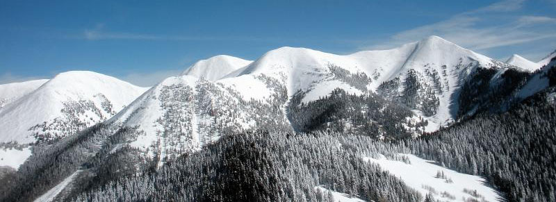
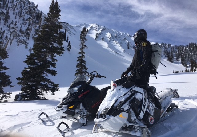
The mountains are as white as I have ever seen them. Thanks to Reed Kennard for this shot of the North Group from Gold Knob. Skies are clear and it's looking to be another beautiful day in the mountains. Northeasterly ridge top winds this morning are averaging 15-20 mph with gusts into the 30's. They blew out of the northwest most of the day yesterday with similar speeds. Early morning temperatures are the warmest they have been in about a week, and it's currently 28 degrees at the Geyser Pass Trailhead and 23 on Pre Laurel Peak. UAC Director Mark Staples paid me a visit yesterday and we snowmobiled around La Sal Pass, getting high up under the north face of South Mountain. We found excellent powder conditions out of the wind zone, but even the upper alpine bowls had soft, if not slightly wind affected snow. Most of the wind activity over the past few days has been confined to the highest peaks and ridges, with mostly calm conditions below. South facing aspects were getting moist late in the day, and will likely be lightly crusted over this morning. Observer Reed Kennard was out yesterday with a party in the north group. They found a mixed bag of conditions that included some soft, settled powder and damp snow. For a full report of their travels go here. Wind, temperature and humidity on Pre Laurel Peak.(11,700') Storm totals and temperature in Gold Basin.(10,000') Snow totals, temperature and snow/water equivalent at the Geyser Pass Trailhead. (9600')
UAC Director Mark Staples high up under the north face of South Mountain. Though slightly wind affected, good, soft snow can still be found in alpine areas. |
 |
recent activity |
| type | aspect/elevation | characteristics |
|---|

|
|
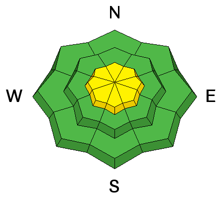
LIKELIHOOD
 LIKELY
UNLIKELY
SIZE
 LARGE
SMALL
TREND
 INCREASING DANGER
SAME
DECREASING DANGER
|
|
description
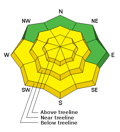
Wind slabs old and new continue to be the primary concern. Northerly winds have deposited shallow wind drifts on southerly aspects, primarily in upper elevation terrain. Mostly shallow and manageable, they'll be a bit more stubborn today, but be alert to areas of wind drifted snow on the lee sides of ridge crests and terrain features, and look for areas of cross loading on the sides of gully walls and sub-ridges. It may also still be possible to trigger an older, deeper wind slab that formed during the storm cycle of last weekend. Very strong, southwest winds on Monday deposited vast amounts of snow on to leeward, northerly aspects. Most of these slabs are pretty well stuck in place, but there could be an isolated fat pocket here in there that could break out and take you for an ugly ride. Pay attention to smooth rounded pillows of snow, especially if they sound hollow like a drum, and avoid wind loaded slopes with steep convexities. |
| type | aspect/elevation | characteristics |
|---|

|
|
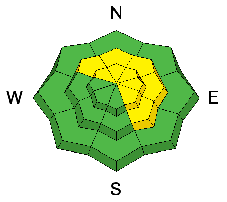
LIKELIHOOD
LIKELY
UNLIKELY
SIZE
 LARGE
SMALL
TREND
INCREASING DANGER
SAME
DECREASING DANGER
|
|
description
Snowpits dug yesterday reveal a strengthening snowpack and we are trending toward mostly stable conditions. We found a problematic layer of faceted snow about 2' below the surface that propagated under an extended column test (ECTP 23) on two SE facing slopes around 10,700'. I expect this weakness to heel over the next several days with daytime heating but it prevents me from giving the green light for now. On northerly facing slopes we found mostly strong snow, but I suspect there are a few places with lingering facets, particularly in areas of more extreme, rocky, radical terrain. If you start to push into bigger terrain, take the time to dig down about three feet to evaluate the snow stability. |
| type | aspect/elevation | characteristics |
|---|

|
|
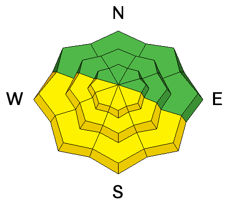
LIKELIHOOD
 LIKELY
UNLIKELY
SIZE
 LARGE
SMALL
TREND
 INCREASING DANGER
SAME
DECREASING DANGER
|
|
description
With daytime heating we may some loose, wet slide activity on sun exposed slopes. I don't see these packing much of a punch, but it's good to be aware of signs of instability such as roller balls, and sloppy wet snow, and good practice to stay off of steep slopes when these signs are present. |
 |
weather High pressure and sunny skies are on tap through the week with high temperatures at 10,000' to be in the low 30's. A change may be in store by the weekend. |
| general announcements Road Conditions: The road to Geyser Pass Trailhead is plowed but down to one lane in places. The Forest Service will be bringing in equipment on Tuesday to widen it, and the road will be closed all day. Grooming: A crew of dedicated cross country skiers shoveled out the drift on the Gold Basin Road and all lower trails were groomed yesterday.
If you are getting out into the mountains, we love to hear from you! You can SUBMIT OBSERVATIONS ONLINE If you would like to have avalanche advisories emailed to you, SIGN UP HERE Benefit the Utah Avalanche Center when you shop from Backcountry.com or REI: Click this link for Backcountry.com or this link to REI, shop, and they will donate a percent of your purchase price to the UAC. Both offer free shipping (with some conditions) so this costs you nothing! The information in this advisory is from the US Forest Service which is solely responsible for its content. This advisory describes general avalanche conditions and local variations always occur. |