25th Annual Black Diamond Fall Fundraising Party
Thursday, September 13; 6:00-10:00 PM; Black Diamond Parking Lot
25th Annual Black Diamond Fall Fundraising Party
Thursday, September 13; 6:00-10:00 PM; Black Diamond Parking Lot
| Advisory: Moab Area Mountains | Issued by Eric Trenbeath for Sunday - January 22, 2017 - 6:15am |
|---|

|
bottom line The avalanche danger is CONSIDERABLE today and human triggered avalanches are likely on steep slopes on all aspects. Avalanches within the storm snow remain the primary concern, but a rising danger for fresh wind slabs will develop during the day. Look for signs of instability such as cracking in the snow surface and avoid slopes with recent deposits of wind drifted snow. Cautious route finding and conservative decision making are essential for safe, backcountry travel today.
|
 |
special announcement Road Conditions: The road to Geyser Pass Trailhead has not been plowed throughout the storm event and 14" of snow has accumulated at the parking lot. Intrepid travelers with 4x4 and chains all around have made it all the way while others have made it as far as the Trans La Sal Trailhead. With another round of heavy snow forecasted for Monday, plowing may not happen until Tuesday. Backcountry 101 Avalanche Class We will be offering a Backcountry 101 avalanche class on Feb 3, 4. This course will include a night classroom session and a day in the field. Cost is $125 with proceeds to benefit the Utah Avalanche Center Moab. For more information or to sign up go here. |
 |
current conditions Well this has been some January! Up to two feet of snow has fallen in the mountains since Thursday night bringing our total for the month up to around 60". Today expect to find deep powder snow, tough trail breaking, and numerous opportunities to get your snowmobile stuck. Northwest winds yesterday were pretty well behaved averaging 15-20 mph along ridge tops with gusts near 30. They really dropped off overnight and are currently in the single digits. Skies are mostly clear this morning and it's cold! The temperature at Geyser Pass Trailhead is 9 degrees and it's 2 on Pre Laurel Peak. Storm totals since Thursday night: Gold Basin 23" with 1.8" H20 Geyser Pass Trailhead 16" with 1.3" H20 Wind, temperature and humidity on Pre Laurel Peak.(11,700') Storm totals and temperature in Gold Basin.(10,000') Snow totals, temperature and snow/water equivalent at the Geyser Pass Trailhead. (9600') |
 |
recent activity Conditions were sensitive yesterday with soft, cohesive storm slabs reacting to human triggers. A touring party up on Noriega's ridge remotely triggered two avalanches up to 20" deep on a steep, convex, north facing slope. The slabs failed at the old snow interface, running on a layer of graupel that came in at the beginning of the first storm on Thursday.
Photo 1: Ed Grote, photo 2: Dave Garcia (note the interface within the slab between the two storm events). |
| type | aspect/elevation | characteristics |
|---|

|

|
LIKELIHOOD
 LIKELY
UNLIKELY
SIZE
 LARGE
SMALL
TREND
 INCREASING DANGER
SAME
DECREASING DANGER
|
|
description
Storm slabs will be less sensitive today, but they will still be reactive to human triggers on slopes steeper than 35 degrees on all aspects at mid and upper elevations. Up to 2' deep these slabs will be beyond the manageable range and you don't want to get caught in them. Choose your terrain wisely today and stick to lower angle slopes. |
| type | aspect/elevation | characteristics |
|---|

|
|
LIKELIHOOD
LIKELY
UNLIKELY
SIZE
LARGE
SMALL
TREND
 INCREASING DANGER
SAME
DECREASING DANGER
|
|
description
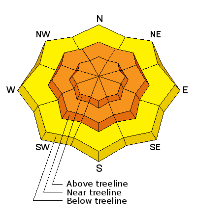
Southwesterly winds will be on the increase today and there is plenty of loose snow to blow around. Be on the lookout for developing wind slabs in upper elevation, wind exposed terrain and avoid steep slopes with recent deposits of wind drifted snow. The danger will be most pronounced on slopes facing NW-N-E, but with so much snow available for transport, any terrain feature will be able to capture some snow, and wind slab development will be possible on all aspects above tree line. |
| type | aspect/elevation | characteristics |
|---|

|

|
LIKELIHOOD
 LIKELY
UNLIKELY
SIZE
 LARGE
SMALL
TREND
 INCREASING DANGER
SAME
DECREASING DANGER
|
|
description
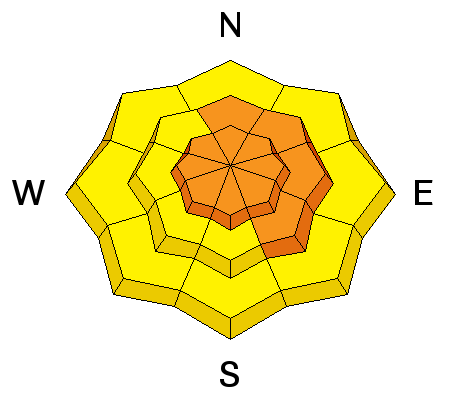
The new snow load is putting buried weak layers in the snowpack to the test including surface hoar and buried near surface facets. Though generally an isolated problem, the danger for a deep persistent slab avalanche exists on steep, northerly facing aspects right around tree line and above. Heavily featured slopes with rocky, and more radical terrain, or where the snowpack is shallow are the most suspect. |
 |
weather We'll see a brief lull in the action before the next system moves in this evening. Today Snow showers, mainly after 3pm. Widespread blowing snow after 3pm. High near 20. Breezy, with a west wind 15 to 20 mph becoming south southwest 20 to 25 mph in the afternoon. Winds could gust as high as 40 mph. Chance of precipitation is 80%. Total daytime snow accumulation of 1 to 2 inches possible. Tonight Snow showers. The snow could be heavy at times. Widespread blowing snow. Low around 17. Very windy, with a south southwest wind 30 to 40 mph, with gusts as high as 55 mph. Chance of precipitation is 90%. New snow accumulation of 4 to 8 inches possible. Monday Snow showers. The snow could be heavy at times. Widespread blowing snow, mainly before 5pm. High near 23. Very windy, with a southwest wind 30 to 40 mph decreasing to 20 to 30 mph in the afternoon. Winds could gust as high as 55 mph. Chance of precipitation is 90%. New snow accumulation of 5 to 9 inches possible. Monday Night Snow showers. The snow could be heavy at times. Low around 8. West wind 10 to 15 mph. Chance of precipitation is 80%. New snow accumulation of 4 to 8 inches possible. Tuesday Snow showers likely before 11am, then snow likely after 11am. The snow could be heavy at times. Mostly cloudy, with a high near 16. West northwest wind 10 to 15 mph. Chance of precipitation is 60%. |
| general announcements Grooming: Heavy snow through the weekend will prevent grooming. If you are getting out into the mountains, we love to hear from you! You can SUBMIT OBSERVATIONS ONLINE If you would like to have avalanche advisories emailed to you, SIGN UP HERE Benefit the Utah Avalanche Center when you shop from Backcountry.com or REI: Click this link for Backcountry.com or this link to REI, shop, and they will donate a percent of your purchase price to the UAC. Both offer free shipping (with some conditions) so this costs you nothing! Benefit the Utah Avalanche Center when you buy or sell on ebayIf you sign up for AmazonSmile and designate the Utah Avalanche Center as your favorite charity, they will donate a portion of everything you spend to the UAC. I doesn't cost you a penny and we'd really appreciate the help. The information in this advisory is from the US Forest Service which is solely responsible for its content. This advisory describes general avalanche conditions and local variations always occur. |


