25th Annual Black Diamond Fall Fundraising Party
Thursday, September 13; 6:00-10:00 PM; Black Diamond Parking Lot
25th Annual Black Diamond Fall Fundraising Party
Thursday, September 13; 6:00-10:00 PM; Black Diamond Parking Lot
| Advisory: Moab Area Mountains | Issued by Eric Trenbeath for Sunday - January 8, 2017 - 7:25am |
|---|


|
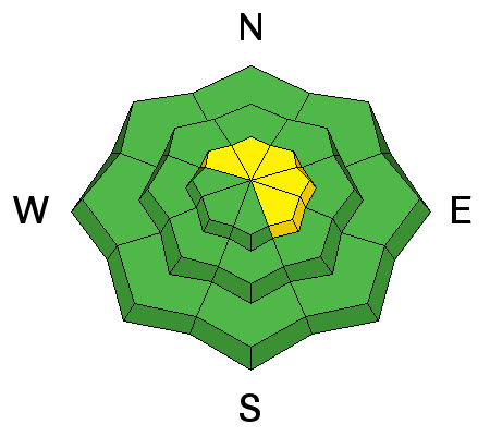
bottom line The avalanche danger is MODERATE on steep, upper elevation, wind exposed terrain that has recent deposits of wind drifted snow. The danger is most pronounced on slopes that face N-NE-E, but cross loading has affected terrain on all aspects in the wind zone. Avoid slopes that have smooth, rounded pillows, and suspect the lee sides of terrain features such as sub ridges and gully walls. There is also an isolated or MODERATE danger for triggering a deeper, persistent slab avalanche on upper-mid to upper elevation slopes that face NW-NE-SE. Low elevation offers mostly LOW danger.
|
 |
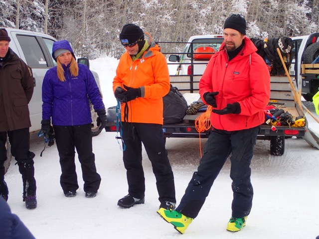
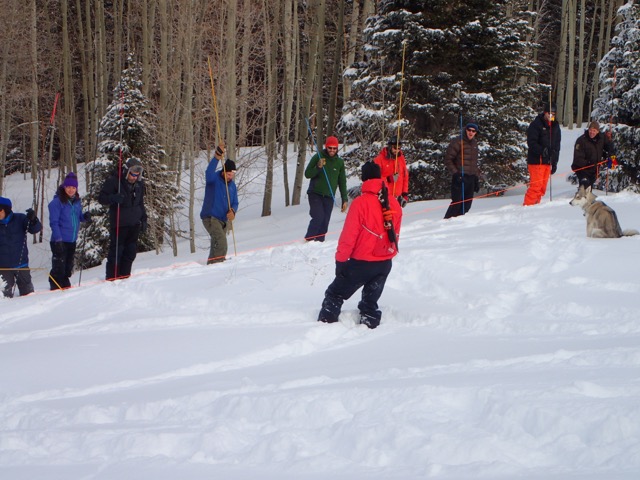
special announcement Backcountry 101 Avalanche Course We will be offering a Backcountry 101 avalanche class on Feb 3, 4. This course will include a night classroom session and a day in the field. Cost is $125 with proceeds to benefit the Utah Avalanche Center Moab. For more information or to sign up go here. Grand County Search and Rescue and the Winter Rescue Team conduct joint training. GCSAR and WRT held a joint training session on Saturday above the Geyser Pass Trailhead. Thanks to everyone who turned out, and a big shout out to ex Alta ski patroller Scott Sole for lending his expertise. It's a crack group who have proved their skills time and time again. We are fortunate to have such a resource here in our little mountain range.
Scott Sole explains the finer points of avalanche rescue. (photo by Bego Gerhart)
Team members engage in probe line practice. (photo by Bego Gerhart) |
 |
current conditions It's great to hear from so many people who are getting out and enjoying the new snow. In spite of moderate, and relatively sustained southwest winds throughout the week, folks have been finding good skiing and riding conditions in sheltered locations below tree line where about 6" of settled, medium density powder can be found. Exposed, south facing slopes have taken an unfortunate hit from the wind, and yesterday afternoon again saw south westerlies blowing in the 20-30 mph range for several hours. They have backed off into the 10-15 mph range but will increase again later today. It's currently a warm 22 degrees on Pre Laurel Peak and 27 at the Geyser Pass Trailhead. Observations streamed in from yesterday. I really appreciate it and it's great to know so many local folks are out and about and staying on top of conditions. It's a great community! For a full list of recent observations go here. Base depth in Gold Basin: 47" Season total: 120" Percentage of normal: 169% Storm totals and temperature in Gold Basin.(10,000') Wind, temperature and humidity on Pre Laurel Peak.(11,700') Snow totals, temperature and snow/water equivalent at the Geyser Pass Trailhead. (9600')
Wind exposed, south and west facing slopes have taken a hit, especially above tree line. Best bet for good snow is to seek out sheltered locations. (photo by Reed Kennard) A report of his travels can be found here. |
 |
recent activity |
| type | aspect/elevation | characteristics |
|---|

|
|
LIKELIHOOD
 LIKELY
UNLIKELY
SIZE
 LARGE
SMALL
TREND
 INCREASING DANGER
SAME
DECREASING DANGER
|
|
description
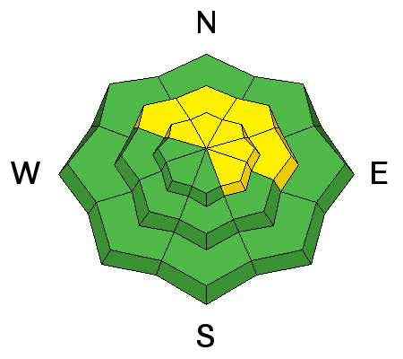
Today your main concern continues to be wind slabs old and new, in upper elevation, wind exposed terrain. Slabs formed during the storm will be less sensitive, but more recent drifts will have formed from the winds last night. N-E-NE facing slopes will be the most suspect, but cross loading is a factor on all aspects above tree line. Avoid slopes steeper than about 30 degrees where you can detect recent deposits of wind drifted snow, and look for signs of instability such as cracking in the snow surface. |
| type | aspect/elevation | characteristics |
|---|

|
|
LIKELIHOOD
LIKELY
UNLIKELY
SIZE
 LARGE
SMALL
TREND
 INCREASING DANGER
SAME
DECREASING DANGER
|
|
description
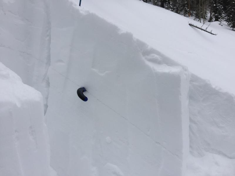
Our snowpack still contains a few weak layers. In most cases these layers are not proving to be reactive, and the chances of triggering a deep and dangerous, persistent slab are growing less likely. However, isolated areas remain, and I received this report from Brian Sparks yesterday who turned off from a NE facing slope right around tree line due to a collapse, and the presence of a weak layer that propagated under an extended column test. Though making up a small portion of the terrain, steep, northerly facing slopes right around tree line and above should still be treated with suspicion, and a careful stability analysis should be performed before jumping into this type of terrain.
This Dave Garcia photo illustrates a weak layer of concern. Taken on Wednesday, up to 10" of new snow, or more if drifted, now sits on top of the old snow surface. |
 |
weather An "atmospheric river" is poised to deliver moisture throughout the region for the upcoming week. How much this will affect our mountains remains to be seen as we appear to be just on the southern edge of the flow. Best chance for significant snow will come on Monday. Today Snow likely, mainly before 3pm. Cloudy, with a high near 30. Breezy, with a southwest wind 15 to 20 mph, with gusts as high as 35 mph. Chance of precipitation is 70%. Total daytime snow accumulation of 1 to 2 inches possible. Tonight A 50 percent chance of snow. Cloudy, with a low around 25. Breezy, with a southwest wind around 20 mph, with gusts as high as 35 mph. New snow accumulation of 1 to 2 inches possible. Monday Snow, mainly before 3pm. High near 31. Breezy, with a south southwest wind 20 to 25 mph, with gusts as high as 40 mph. Chance of precipitation is 90%. New snow accumulation of 5 to 9 inches possible. Monday Night Snow. Low around 19. Breezy, with a west southwest wind 20 to 25 mph, with gusts as high as 40 mph. Chance of precipitation is 80%. New snow accumulation of 3 to 7 inches possible. Tuesday Snow likely, mainly before 11am. Partly sunny, with a high near 28. Breezy, with a west southwest wind 15 to 20 mph, with gusts as high as 35 mph. Chance of precipitation is 70%. Tuesday Night A 40 percent chance of snow. Mostly cloudy, with a low around 21. Breezy. Wednesday Snow likely. Cloudy, with a high near 28. Breezy. Chance of precipitation is 60%. |
| general announcements Road Conditions: The road is plowed and clear. Grooming: Matt and Travis groomed all of the trails on Saturday. If you are getting out into the mountains, we love to hear from you! You can SUBMIT OBSERVATIONS ONLINE If you would like to have avalanche advisories emailed to you, SIGN UP HERE Benefit the Utah Avalanche Center when you shop from Backcountry.com or REI: Click this link for Backcountry.com or this link to REI, shop, and they will donate a percent of your purchase price to the UAC. Both offer free shipping (with some conditions) so this costs you nothing! Benefit the Utah Avalanche Center when you buy or sell on ebay - set the Utah Avalanche Center as a favorite non-profit in your ebay account here and click on ebay gives when you buy or sell. You can choose to have your seller fees donated to the UAC, which doesn't cost you a penny. The information in this advisory is from the US Forest Service which is solely responsible for its content. This advisory describes general avalanche conditions and local variations always occur. |


.JPG)