25th Annual Black Diamond Fall Fundraising Party
Thursday, September 13; 6:00-10:00 PM; Black Diamond Parking Lot
25th Annual Black Diamond Fall Fundraising Party
Thursday, September 13; 6:00-10:00 PM; Black Diamond Parking Lot
| Advisory: Moab Area Mountains | Issued by Eric Trenbeath for Friday - January 6, 2017 - 7:04am |
|---|

|
bottom line The avalanche danger is CONSIDERABLE in steep, upper elevation, wind exposed terrain where new snow and winds have created dangerous avalanche conditions. Avoid steep slopes with recent deposits of wind drifted snow. and stick to lower angle sheltered terrain. Out of the wind zone the avalanche danger is MODERATE. Low elevations offer mostly LOW danger.
|
 |
special announcement Grand County will be plowing the road today and the gate will be closed by 9:00 a.m. We will be offering a Backcountry 101 avalanche class on Feb 3, 4. This course will include a night classroom session and a day in the field. Cost is $125 with proceeds to benefit the Utah Avalanche Center Moab. For more information or to sign up go here. |
 |
current conditions All said and done, snow totals over the past 24 hours amount to about 5" at the Geyser Pass trailhead and 10" in Gold Basin. Snowfall from this storm was spotty and erratic with Moab getting in on the action with about an inch, and upper Castle Valley reporting 6-7". Southwesterly ridge top winds that have been blowing steadily in the 20-30 mph for days, shifted to the NW and began tapering off around 6:00 last night. They are currently averaging about 15 mph from the NW, and it's a frigid -4 degrees at 10,000'. Expect winds to increase later today. Ex La Sal forecaster Brian Murray was up yesterday and sent in this observation. For a full list of recent observations go here. Storm totals and temperature in Gold Basin.(10,000') Wind, temperature and humidity on Pre Laurel Peak.(11,700') Snow totals, temperature and snow/water equivalent at the Geyser Pass Trailhead. (9600') |
 |
recent activity |
| type | aspect/elevation | characteristics |
|---|

|

|
LIKELIHOOD
 LIKELY
UNLIKELY
SIZE
 LARGE
SMALL
TREND
 INCREASING DANGER
SAME
DECREASING DANGER
|
|
description
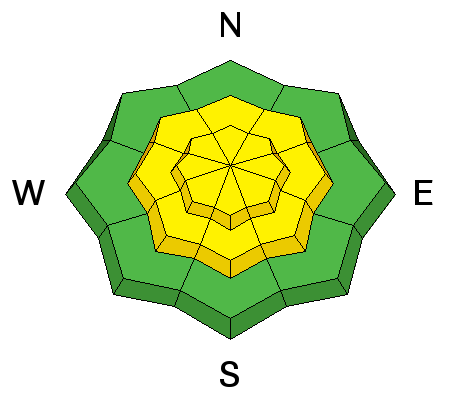
Today your main concern will be recently formed wind slabs on the lee sides of ridge crests and terrain features in upper elevation, wind exposed terrain. Avoid slopes steeper than about 30 degrees where you can detect recent deposits of wind drifted snow and look for signs of instability such as cracking in the snow surface. |
| type | aspect/elevation | characteristics |
|---|

|
|
LIKELIHOOD
 LIKELY
UNLIKELY
SIZE
LARGE
SMALL
TREND
INCREASING DANGER
SAME
DECREASING DANGER
|
|
description
The new snow started out cold, and then became quite dense, forming it's own cohesive layer that has in many places fallen on top of loose, faceted surface snow, and I'm not sure how well it's going to bond. I'd give things a day to settle out, or at least pay careful attention to how well the new snow has bonded before getting on to slopes steeper than 30 degrees. |
| type | aspect/elevation | characteristics |
|---|

|

|
LIKELIHOOD
LIKELY
UNLIKELY
SIZE
 LARGE
SMALL
TREND
 INCREASING DANGER
SAME
DECREASING DANGER
|
|
description
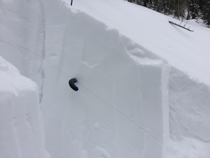
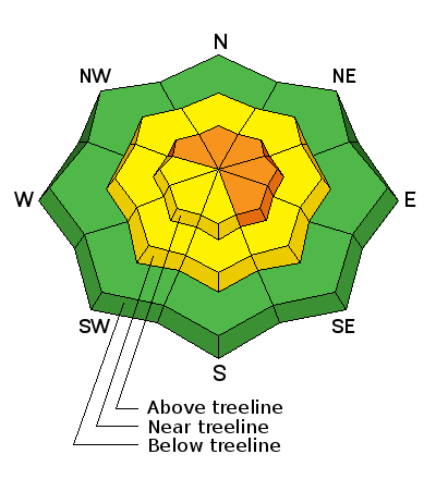
Our snowpack still contains a few weak layers, and the additional weight of the new snow, or a triggered wind slab, may have the potential to cause a failure on one of these buried weak layers. Dave Garcia's thoughts on this problem before the new snow fell can be found here. You are most likely to encounter this problem slopes steeper than about 35 degrees, right around tree line and above, that face NW-E-SE.
This Dave Garcia photo illustrates a weak layer of concern. Taken on Wednesday, up to 10" of new snow, or more if drifted, sits on top of the old snow surface. |
 |
weather Today Mostly sunny and cold, with a high near 10. Wind chill values as low as -20. Blustery, with a northwest wind 10 to 15 mph increasing to 15 to 20 mph in the morning. Winds could gust as high as 35 mph. Tonight Mostly clear, with a low around 2. Wind chill values as low as -20. Blustery, with a west northwest wind 10 to 20 mph, with gusts as high as 35 mph. Saturday Mostly cloudy, with a high near 20. Wind chill values as low as -15. Southwest wind 10 to 15 mph, with gusts as high as 25 mph. Saturday Night A 30 percent chance of snow showers, mainly after 11pm. Cloudy, with a low around 14. Breezy, with a southwest wind 15 to 20 mph, with gusts as high as 30 mph. Sunday A 50 percent chance of snow. Cloudy, with a high near 27. Breezy, with a southwest wind 15 to 20 mph, with gusts as high as 35 mph. |
| general announcements Road Conditions: Grand County will be plowing the road today so it will be clear for the weekend. Thanks guys! Grooming: Not currently scheduled. If you are getting out into the mountains, we love to hear from you! You can SUBMIT OBSERVATIONS ONLINE If you would like to have avalanche advisories emailed to you, SIGN UP HERE Benefit the Utah Avalanche Center when you shop from Backcountry.com or REI: Click this link for Backcountry.com or this link to REI, shop, and they will donate a percent of your purchase price to the UAC. Both offer free shipping (with some conditions) so this costs you nothing! Benefit the Utah Avalanche Center when you buy or sell on ebay - set the Utah Avalanche Center as a favorite non-profit in your ebay account here and click on ebay gives when you buy or sell. You can choose to have your seller fees donated to the UAC, which doesn't cost you a penny. The information in this advisory is from the US Forest Service which is solely responsible for its content. This advisory describes general avalanche conditions and local variations always occur. |