25th Annual Black Diamond Fall Fundraising Party
Thursday, September 13; 6:00-10:00 PM; Black Diamond Parking Lot
25th Annual Black Diamond Fall Fundraising Party
Thursday, September 13; 6:00-10:00 PM; Black Diamond Parking Lot
| Advisory: Moab Area Mountains | Issued by Eric Trenbeath for Thursday - January 5, 2017 - 6:52am |
|---|

|
bottom line The avalanche danger is CONSIDERABLE today as wind and accumulating new snow combine to create dangerous avalanche conditions on steep, wind loaded slopes in upper elevation, wind exposed terrain. Be alert to rapidly changing conditions and look for signs of instability such as cracking in the snow surface and avoid steep slopes with recent deposits of wind drifted snow. Stay out from under large, steep, avalanche paths that face N-NE-E where even small natural releases have the potential to entrain significant amounts of snow. Out of the wind zone the avalanche danger is MODERATE. Low elevations offer mostly LOW danger.
|
 |
current conditions Gold Basin has picked up 5" of new snow over the past 24 hours with only 2" falling at the Geyser Pass Trailhead. Moderate to strong SW winds have been blowing steady for the past several days, and this morning they are continuing in the 20-30 mph range with gusts near 40 along ridge tops. Temperature at 10,000' is 24 degrees. Many south facing aspects have been stripped of snow and the surface above tree line is beginning to look like a moonscape. Let's hope we get a significant refresh out of this! Dave Garcia was out and about yesterday and sent in this observation that notes changing conditions and an increasing avalanche danger. For a full list of recent observations go here. Storm totals and temperature in Gold Basin.(10,000') Wind, temperature and humidity on Pre Laurel Peak.(11,700') Snow totals, temperature and snow/water equivalent at the Geyser Pass Trailhead. (9600') |
 |
recent activity
This skier triggered avalanche occurred on Monday. Expect today's wind slabs to be deeper and more widespread.. For more details go here. |
| type | aspect/elevation | characteristics |
|---|

|

|
LIKELIHOOD
 LIKELY
UNLIKELY
SIZE
 LARGE
SMALL
TREND
 INCREASING DANGER
SAME
DECREASING DANGER
|
|
description
Today you will need to be on the lookout for newly formed wind slabs on the lee sides of ridge crests and terrain features in upper elevation, wind exposed terrain. Avoid slopes steeper than about 30 degrees where you can detect recent deposits of wind drifted snow and look for signs of instability such as cracking in the snow surface. |
| type | aspect/elevation | characteristics |
|---|

|
|
LIKELIHOOD
 LIKELY
UNLIKELY
SIZE
 LARGE
SMALL
TREND
 INCREASING DANGER
SAME
DECREASING DANGER
|
|
description
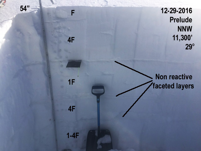
Recent snowpits have shown an overall stabilization and strengthening of the snowpack, and I don't expect the new snow to have much of an effect on buried weak layers. The exception might be weak sugary snow developing just below the old snow surface. As long as weak layers are present, it's still advisable to perform your own snowpack analysis before jumping in to any steep, north facing terrain, and the new snow alone should be enough to keep you out of those areas for a few days,
|
 |
weather Heavy snow is forecasted for the mountains of Western Colorado and SE Utah today, but I'm not convinced we are going to see the optimistic forecasted totals for our area. Snow, heavy at times, will continue through tonight until the storm exits the area by early Friday morning. Today Snow showers. The snow could be heavy at times. Widespread blowing snow. Widespread fog, mainly after 11am. High near 19. Wind chill values as low as -15. Windy, with a west wind 25 to 30 mph, with gusts as high as 50 mph. Chance of precipitation is 100%. Total daytime snow accumulation of 7 to 11 inches possible. Tonight Snow showers, mainly before 3am. The snow could be heavy at times. Widespread blowing snow before 11pm. Widespread fog, mainly before 4am. Low around -1. Wind chill values as low as -20. Breezy, with a west wind 15 to 20 mph decreasing to 10 to 15 mph after midnight. Winds could gust as high as 35 mph. Chance of precipitation is 80%. New snow accumulation of 5 to 9 inches possible. Friday A 30 percent chance of snow showers before 11am. Mostly sunny, with a high near 12. Wind chill values as low as -20. North wind 5 to 10 mph, with gusts as high as 20 mph. Friday Night Mostly clear, with a low around 2. Wind chill values as low as -15. Southwest wind around 10 mph. Saturday Partly sunny, with a high near 20. Southwest wind 10 to 15 mph. Saturday Night A 20 percent chance of snow showers after 11pm. Mostly cloudy, with a low around 12. Sunday A 30 percent chance of snow showers, mainly after 11am. Mostly cloudy, with a high near 25. |
| general announcements Road Conditions: Grand County got up and widened the road yesterday ahead of the next storm. Thanks guys! Grooming: Just ahead of the new snow, groomers got out yesterday and set corduroy with the Ginzu into Gold Basin and up to Geyser Pass. The upper and lower meadow loops have been rolled out. If you are getting out into the mountains, we love to hear from you! You can SUBMIT OBSERVATIONS ONLINE If you would like to have avalanche advisories emailed to you, SIGN UP HERE Benefit the Utah Avalanche Center when you shop from Backcountry.com or REI: Click this link for Backcountry.com or this link to REI, shop, and they will donate a percent of your purchase price to the UAC. Both offer free shipping (with some conditions) so this costs you nothing! Benefit the Utah Avalanche Center when you buy or sell on ebay - set the Utah Avalanche Center as a favorite non-profit in your ebay account here and click on ebay gives when you buy or sell. You can choose to have your seller fees donated to the UAC, which doesn't cost you a penny. The information in this advisory is from the US Forest Service which is solely responsible for its content. This advisory describes general avalanche conditions and local variations always occur. |