25th Annual Black Diamond Fall Fundraising Party
Thursday, September 13; 6:00-10:00 PM; Black Diamond Parking Lot
25th Annual Black Diamond Fall Fundraising Party
Thursday, September 13; 6:00-10:00 PM; Black Diamond Parking Lot
| Advisory: Moab Area Mountains | Issued by Eric Trenbeath for Wednesday - December 28, 2016 - 6:58am |
|---|


|
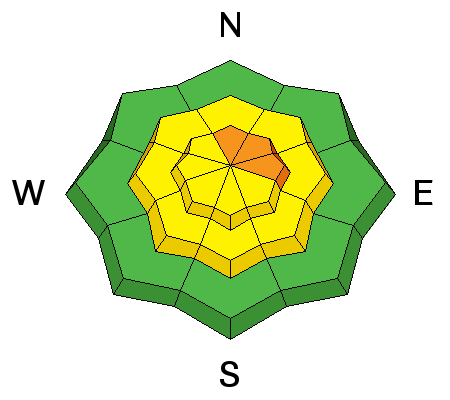
bottom line Overall the avalanche danger is MODERATE, but areas of CONSIDERABLE danger remain on steep upper elevation slopes that face N-NE-E. Backcountry travelers need to maintain heightened avalanche awareness. Avoid steep, wind drifted terrain, and continue to carefully evaluate any slope steeper than about 30 degrees.
|
 |
special announcement Grand County has plowed the road to the Geyser Pass Trailhead. |
 |
current conditions The mountains received 8" -15" of snow from the Christmas storm depending on elevation, and good powder conditions can still be had. Winds over the weekend were strong and erratic but by late Sunday had backed off to non-existent. The new snow is settling out but reports of collapsing and whumphing were still coming in on Monday. We are entering the down side of the curve as we slide from considerable danger to moderate, but this is where most avalanche accidents happen and it's still very much heads up out there. Dave Garcia was out and about on Monday and sent in this observation. For a full list of recent observations go here. Storm totals and temperature in Gold Basin.(10,000') Wind, temperature and humidity on Pre Laurel Peak.(11,700') Snow totals, temperature and snow/water equivalent at the Geyser Pass Trailhead.(9600') |
 |
recent activity |
| type | aspect/elevation | characteristics |
|---|

|

|
LIKELIHOOD
 LIKELY
UNLIKELY
SIZE
 LARGE
SMALL
TREND
 INCREASING DANGER
SAME
DECREASING DANGER
|
|
description
With plenty of snow available for transport, any increase in wind will begin to move snow around forming fresh drifts on the lee sides of ridge crests and terrain features. Additionally, strong, gusty winds on Saturday formed stiff wind slabs on all aspects in upper elevation, wind exposed terrain. New snow on Sunday covered them up making them harder to detect. If triggered, wind slabs have the potential to step down into buried weak layers causing a deeper and more dangerous persistent slab avalanche. Watch your slope angles and avoid slopes steeper than about 30 degrees in upper elevation terrain on all aspects. |
| type | aspect/elevation | characteristics |
|---|

|
|
LIKELIHOOD
LIKELY
UNLIKELY
SIZE
 LARGE
SMALL
TREND
 INCREASING DANGER
SAME
DECREASING DANGER
|
|
description
The snow pack structure is complex and poor in many areas, and collapsing and whumphing continue to communicate instability. Newly deposited wind slabs have added additional stress and increased the likelihood for triggering a deep, persistent slab avalanche. You are most likely to encounter this problem on steep, upper elevation slopes that face N-NE-E, but weak layers exist on all aspects at mid and upper elevations. Best bet is to keep your slope angle to around 30 degrees and avoid slopes that appear to be drifted. |
 |
weather Wednesday Sunny, with a high near 26. West wind around 15 mph, with gusts as high as 25 mph. Wednesday Night Mostly clear, with a low around 15. West northwest wind 10 to 15 mph. Thursday Sunny, with a high near 28. West northwest wind around 10 mph. Thursday Night Mostly clear, with a low around 16. Friday A 20 percent chance of snow after 11am. Mostly sunny, with a high near 26. |


