25th Annual Black Diamond Fall Fundraising Party
Thursday, September 13; 6:00-10:00 PM; Black Diamond Parking Lot
25th Annual Black Diamond Fall Fundraising Party
Thursday, September 13; 6:00-10:00 PM; Black Diamond Parking Lot
| Advisory: Moab Area Mountains | Issued by Eric Trenbeath for Friday - December 23, 2016 - 6:03am |
|---|

|
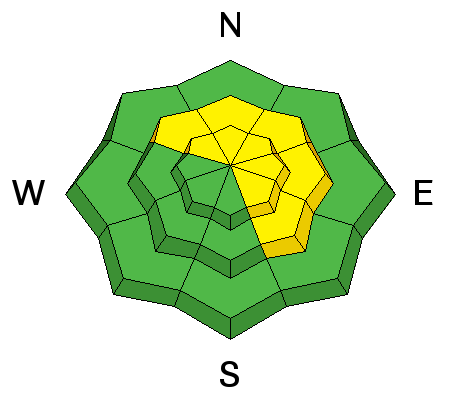
bottom line The avalanche danger is MODERATE today in steep upper elevation terrain where you can detect recent deposits of wind drifted snow. Be alert to recently formed wind slabs on the lee sides of ridge crests and terrain features and look for signs of instability such as cracking or collapsing in the snow pack. There is also a MODERATE danger for triggering a deep and dangerous persistent slab avalanche on steep slopes in mid-upper elevation terrain, that have a W-NE-SE aspect.
|
 |
special announcement Grand County will not be plowing the road this morning as they need to direct their focus on city streets and other county road access. With the Christmas weekend coming up, you will likely be on your own getting to the trailhead, and 4wd will be required. |
 |
current conditions This storm didn't produce quite the amount that was hoped for but we did pick up 6"-8" of 10% density snow overnight which is nothing to thumb our noses at. The new snow will significantly improve conditions in most areas, but wind exposed slopes above tree line still have a way to go. In my travels yesterday, I found that many of these slopes had been scoured down to the rocks. Overnight winds averaged 15-20 mph from the SSW with gusts near 30. They have backed off into the single digits this morning and have switched to the NW. It's currently 17 degrees on Pre Laurel Peak and 25 at the Geyser Pass Trailhead. Thanks to everyone who has been sending in observations. Keep them coming! To see recent observations go here. To send in an observation go here. Storm totals and temperature in Gold Basin.(10,000') Wind, temperature and humidity on Pre Laurel Peak.(11,700') Snow totals, temperature and snow/water equivalent at the Geyser Pass Trailhead.(9600')
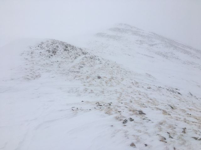
Things took a beating above tree line this week with southwesterly slopes like these near Pre-Laurel Peak getting scoured down to the rocks. |
 |
recent activity
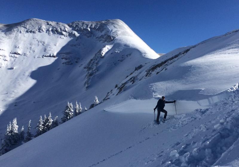
The storm cycle of December 15-16, produced some large avalanches including this one in Horse Creek Chute on a NE aspect at about 11,400'. Overall I was surprised that there wasn't more activity given the prevalence of the weak, faceted layer that this and, the other slides apparently ran on. For a list of the other slides I observed go here. |
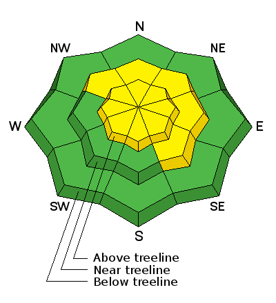
| type | aspect/elevation | characteristics |
|---|

|
|
LIKELIHOOD
 LIKELY
UNLIKELY
SIZE
 LARGE
SMALL
TREND
 INCREASING DANGER
SAME
DECREASING DANGER
|
|
description
In my travels yesterday, I observed new, shallow wind slabs forming on the lee sides of ridge crests and terrain features in upper elevation, wind exposed terrain. With the addition of 6" of new snow and overnight winds in the 20-30 mph range, slabs will be more wide spread and connected today. Avoid steep slopes where you can detect recent deposits of wind drifted snow and be alert to signs of instability such as cracking in the snow surface.
I was able to crack out isolated, shallow wind slabs along ridge crests yesterday. These will be more widespread today. |
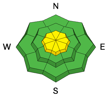
| type | aspect/elevation | characteristics |
|---|

|
|
LIKELIHOOD
LIKELY
UNLIKELY
SIZE
 LARGE
SMALL
TREND
 INCREASING DANGER
SAME
DECREASING DANGER
|
|
description
It's been a week since the occurrence of any natural avalanche activity, but mid to upper elevation slopes that have a NW-NE-SE aspect still harbor weak layers within the snow pack. It may still be possible to trigger a deep, persistent slab avalanche in these areas, particularly on slopes where the weak layers are loaded with recent, as well as old, deposits of wind drifted snow. Only by digging a snow pit and performing stability tests is it possible to determine to the strength of these weak layers, and careful analysis is required before venturing into steep terrain. |
 |
weather As this storm exits the region today, another one is on tap just in time for Christmas. It doesn't look to be a huge producer for us, but we're still thankful! Friday Snow showers, mainly before 7am. High near 30. South southwest wind 10 to 15 mph. Chance of precipitation is 80%. New snow accumulation of around an inch possible. Friday Night Snow showers likely, mainly after 4am. Mostly cloudy, with a low around 20. Breezy, with a south wind 15 to 25 mph, with gusts as high as 45 mph. Chance of precipitation is 60%. New snow accumulation of 2 to 4 inches possible. Saturday Snow likely. Mostly cloudy, with a high near 21. Windy, with a south wind 25 to 30 mph, with gusts as high as 45 mph. Chance of precipitation is 60%. New snow accumulation of 2 to 4 inches possible. Saturday Night Snow. Low around 8. Windy, with a south southwest wind 25 to 30 mph, with gusts as high as 50 mph. Chance of precipitation is 90%. Christmas Day Snow likely. Mostly cloudy, with a high near 14. Breezy. Chance of precipitation is 70%. |