25th Annual Black Diamond Fall Fundraising Party
Thursday, September 13; 6:00-10:00 PM; Black Diamond Parking Lot
25th Annual Black Diamond Fall Fundraising Party
Thursday, September 13; 6:00-10:00 PM; Black Diamond Parking Lot
| Advisory: Moab Area Mountains | Issued by Eric Trenbeath for Tuesday - December 20, 2016 - 6:24pm |
|---|

|
bottom line The avalanche danger is MODERATE this morning but will likely rise to CONSIDERABLE later in the day on steep, wind exposed slopes in upper elevation terrain. Watch for fresh drifts, and recently formed wind slabs on the lee sides of ridge crests and terrain features, and look for signs of instability such as cracking or collapsing in the snow pack. Triggered wind slabs will also have the potential to step down into buried weak layers causing a deeper, and more dangerous persistent slab avalanche. Timing will be everything toady, and staying alert to changing conditions will be paramount.
|
 |
current conditions We look to be poised for another round of snow. A closed low moving in off the coast of southern California is spreading moisture across the Southwest and we should see snowfall beginning mid-day and continuing through the night. With 6-10" in the forecast, timing will be everything today and you will need to be alert to signs of rising avalanche danger. Southwest winds are mostly light this morning averaging 15 mph along ridge tops. It's currently 23 degrees on Pre Laurel Peak and 30 at the Geyser Pass Trailhead. Ace observer Dave Garcia is back from the Grand Canyon, and he was out and about yesterday. Check out his detailed report here. Base depth in Gold Basin is 39" and we have received 92" of total snowfall for the season. Storm totals and temperature in Gold Basin.(10,000') Wind, temperature and humidity on Pre Laurel Peak.(11,700') Snow totals, temperature and snow/water equivalent at the Geyser Pass Trailhead.(9600') |
 |
recent activity
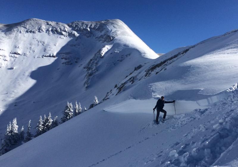
The storm cycle of December 15-16, produced some large avalanches including this one in Horse Creek Chute on a NE aspect at about 11,400'. Overall I was surprised that there wasn't more activity given the prevalence of the weak, faceted layer that this and, the other slides apparently ran on. For a list of the other slides I observed go here. |
| type | aspect/elevation | characteristics |
|---|

|

|
LIKELIHOOD
 LIKELY
UNLIKELY
SIZE
 LARGE
SMALL
TREND
 INCREASING DANGER
SAME
DECREASING DANGER
|
|
description
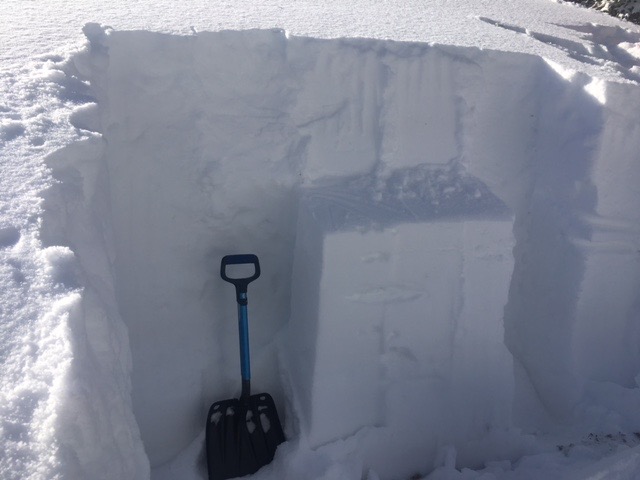
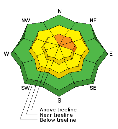
Mid to upper elevation slopes that have a NW-NE-SE aspect still harbor weak layers within the snow pack. These areas already warrant caution, and an additional load of snow will raise the odds for triggering a deep and dangerous, persistent slab avalanche. Prudent travelers will avoid slopes steeper than about 30 degrees in these areas.
The buried, weak faceted layer illustrated here produced that avalanches that occurred last Friday. |
| type | aspect/elevation | characteristics |
|---|

|
|
LIKELIHOOD
LIKELY
UNLIKELY
SIZE
 LARGE
SMALL
TREND
INCREASING DANGER
SAME
DECREASING DANGER
|
|
description
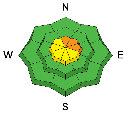
Today you will need to be alert to signs of newly formed wind slabs. Look for fresh drifting on the lee sides of ridge crests and terrain features in upper elevation, wind exposed terrain, and be alert to signs of instability such as cracking in the snow surface. This danger will likely increase throughout the day, and a triggered wind slab has the potential to step down into buried weak layers, causing a deeper, and much more dangerous persistent slab avalanche. |
| type | aspect/elevation | characteristics |
|---|

|

|
LIKELIHOOD
 LIKELY
UNLIKELY
SIZE
 LARGE
SMALL
TREND
INCREASING DANGER
SAME
DECREASING DANGER
|
|
description
As the snow piles up the potential for avalanches within the new snow will increase. More likely later today and into tomorrow, loose snow sluffing, and cohesive soft slab avalanches will be possible on all aspects on slopes steeper than about 35 degrees. If snow piles up as the day progresses, you will want to stay out from under large avalanche paths where even a small natural sluff, or soft slab release will have the potential to entrain a lot of snow. |
 |
weather Thursday Snow showers, mainly after 7am. The snow could be heavy at times. Widespread blowing snow, mainly between noon and 3pm. High near 30. South wind around 15 mph. Chance of precipitation is 90%. New snow accumulation of 6 to 10 inches possible. Thursday Night Snow showers. The snow could be heavy at times. Patchy blowing snow before 4am. Low around 18. Southwest wind 10 to 15 mph, with gusts as high as 25 mph. Chance of precipitation is 90%. New snow accumulation of 9 to 13 inches possible. Friday A 50 percent chance of snow. Partly sunny, with a high near 25. South southwest wind 10 to 15 mph, with gusts as high as 25 mph. New snow accumulation of less than one inch possible. Friday Night A 50 percent chance of snow. Mostly cloudy, with a low around 20. Breezy, with a south southwest wind 20 to 25 mph, with gusts as high as 45 mph. Saturday Snow, mainly after 11am. High near 27. Windy. Chance of precipitation is 80%. |